Loading...

🎉 Enjoy a Free 7-Day Supporter Trial and Unlock Exclusive Perks — No Credit Card Required. Learn more.

Red Sand Beach (Kaihalulu) Trail - Maui

Directions
Map
Pictures
Send to App
Distance:
0.6 Miles / 1.0 km
Type:
Out-and-Back
Difficulty:
Moderate
Time to Hike:
~18 minutes
Features:
Surface Type:
Dirt
Town:
Hana, Hawaii
Directions:
20.752881, -155.984173
Added:
August 28, 2018
Updated:
August 13, 2019
Copy Trail Link Hiking this trail? Send a friend or family member a link to this trail guide for your own safety. Hike at your own risk (disclaimer)
Loading...
Loading...
69'

Total Change
124'

Ascent
124'

Descent

Download the Trail Route for Offline Use

Supporters get exclusive access to download trail routes to the MyHikes app for offline use. Stay prepared on your adventure, even without an internet connection! Become a Supporter today to unlock this feature and hike with confidence.

Send to App

Red Sand Beach (Kaihalulu) Trail - Maui

The Red Sand Beach (a.k.a Kaihalulu) Trail in Hana, Maui, Hawaii, is a moderate 0.6 mile out-and-back hike over to the hidden cove of turquoise waters and red sand beach, Kaihalulu.

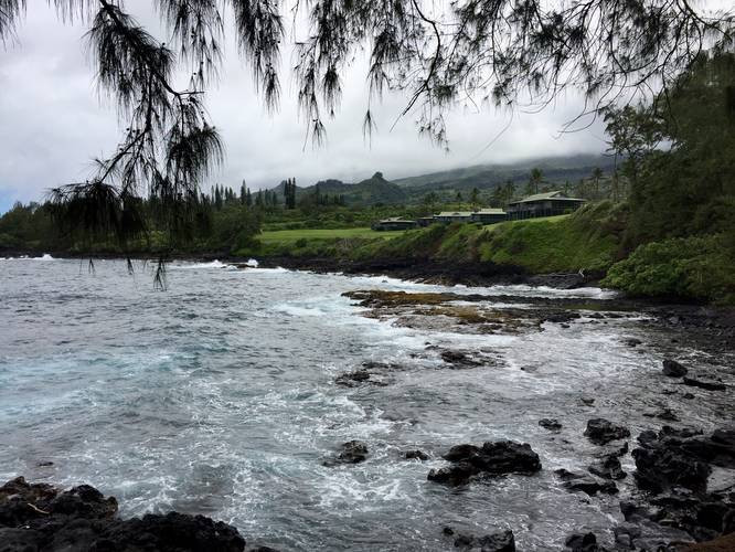
The trail itself is rated at moderate since there are plenty of steeper downhill cliff-side sections where the trail gets narrow; however, a lot of people still do this hike in their flip-flops and sandals. For the most part the trail is moderately trafficked and less popular than the Black Sand Beach Trail.

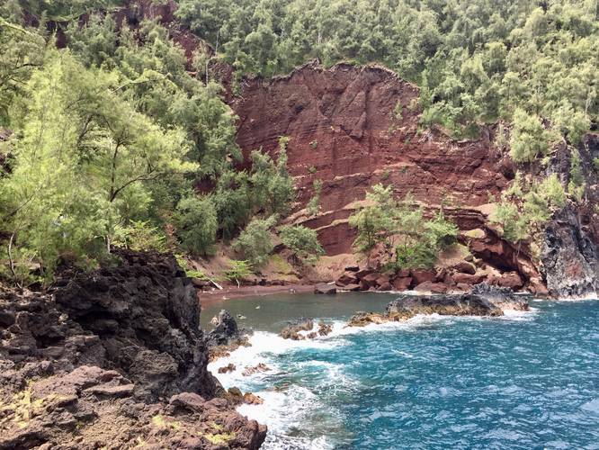
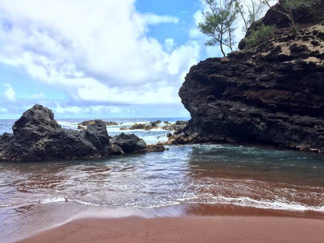
At the end of the trail, about 0.3 miles in, you'll reach the cove of the Red Sand Beach, Kaihalulu, with a large tidal area for snorkeling and swimming. A large natural breakwater sits about 60 feet offshore from the beach, which helps keep the waters in the tidal area stay calmer.

There are plenty of lookout points along this trail of the Red Sand Beach as well.

Trailhead: The trailhead can be found just east of the end of Uakea Rd in Hana; however, this GPS data starts near the corner of Hauoli Rd and Uakea Rd.

Parking: Parking can be found on the side of the road along Uakea Road. There's a parking capacity of about 10 cars, so you may need to wait for a parking space or show up early. Be respectful of the nearby "No Parking" signs and only park where public parking is available.

Beach attire / clothing options: This beach is apparently clothing-optional, which we did not know until after we visited;  however, it may explain some people's choice of swim attire. Just a note if visiting with your family or kids.

Respecting the Land
Hawaiian land is considered sacred to native Hawaiians and many locals, so please stay on-trail, take nothing but photos, and leave nothing but footprints. Respect the locals - don't stay for long and have a backup hike planned in case the parking lot is full.
Explore 30 trails near Hana, HI
  1. Parking

    20.752881, -155.984173
  2. Main Trailhead

    20.752902, -155.984264
  3. View toward Hana Maui Resort from the trail

    20.752072, -155.982042
    View toward Hana Maui Resort from the trail
  4. View / Overlook / Vista

    20.752183, -155.981414
    View / Overlook / Vista
  5. On the Red Sand beach

    20.752575, -155.981567
    On the Red Sand beach
No community routes found. To add your own hike as a Community Route for this Trail guide, leave a Trip Report with an attached GPX file.

Seasons

All

Trip Reports

Trail Guide By:
Admin user profile picture
0.6 miles / 1.0 km
0.6 miles / 1.0 km
July 16, 2019
Hiking
0.6 miles / 1.0 km
July 16, 2019
Got to the Red Sand beach earlier than on our first trip, but the beach was already pretty crowded. The trail out is still just as sketchy in some spots as in 2019, so hikers should wear proper footwear to get to the beach -- plenty of people hiking this in flip-flops and will likely get hurt. Thankfully the parking situation leads this beach to have a maximum capacity. Follow the road signs and only park where allowed. If parking is not available, you can drive around for a while and check again, but respect the locals and do not block the street or park on private driveways, etc.
Hiking
0.6 miles / 1.0 km
August 17, 2018
Hiking
Preview of the MyHikes mobile app interface

Track, Log, and Explore Hikes with the MyHikes App

Shop Landscape Prints
Shop our landscape prints from Maui, Hawaii

Weather Forecast

In Hana, HI

Explore Hiking Trails

You May Also Like

Colorado's Million Dollar Highway - Plan a day's drive adventure along the iconic Million Dollar Highway in Colorado. Explore the best short trails, roadside stops, waterfalls, vistas, ghost towns, and hot springs within a ~6 hour road trip.
Explore

Colorado's Million Dollar Highway

Plan a day's drive adventure along the iconic Million Dollar Highway in Colorado. Explore the best short trails, roadside stops, waterfalls, vistas, ghost towns, and hot springs within a ~6 hour road trip.

Read
Glacier's Going-to-the-Sun Road - Discover the breathtaking beauty of Glacier National Park along the iconic Going-to-the-Sun Road. From stunning roadside stops to picturesque waterfalls and vistas, this engineering marvel offers endless opportunities for exploration.
Explore

Glacier's Going-to-the-Sun Road

Discover the breathtaking beauty of Glacier National Park along the iconic Going-to-the-Sun Road. From stunning roadside stops to picturesque waterfalls and vistas, this engineering marvel offers endless opportunities for exploration.

Read
New York's Best Waterfalls - Whether you're planning a day hike, roadside stop, or a leisurely short walk, this guide provides hikers, travelers, and locals alike with 63 different locations to over 100 scenic waterfalls to help plan your next adventure!
Explore

New York's Best Waterfalls

Whether you're planning a day hike, roadside stop, or a leisurely short walk, this guide provides hikers, travelers, and locals alike with 63 different locations to over 100 scenic waterfalls to help plan your next adventure!

Read

Before you boogie...

Find our trail guides useful? Consider becoming a Supporter to unlock perks!

MyHikes is an indie platform that makes exploring public trails easier for everyone. The platform has no investors, no ads, and is owned and operated by one person, Dave Miller. Dave has personally mapped and written over 1,800 trail guides on MyHikes for the public to explore. MyHikes has helped millions outdoor enthusiasts plan their next adventure.

But it takes a lot of time 🕦, money 💰, work, and espresso shots ☕ to run MyHikes, including hiking , mapping , writing , and publishing new trails with high-quality (accurate) information... along with software engineering (coding) the platform like building new features, website and mobile app development (iOS and Android), site maintainance . and much much more.

Supporters unlock website and mobile app perks with an annual one-time payment of $25 (you renew) 😎👍. Or you can simply make a Donation of your choice. Otherwise, you can support us by telling your friends about MyHikes - both quick and free 🎉

Admin user profile picture

Dave Miller
MyHikes Founder