Loading...

🔥 End of Summer sale! 50% off on Supporter Accounts — now through September 1st. Learn More.

Red Rock Overlook Hike

Directions
Map
Pictures
Send to App
Distance:
1.5 Miles / 2.4 km
Type:
Loop
Difficulty:
Easy
Time to Hike:
~45 minutes
Features:
Surface Type:
Dirt
Town:
Leesburg, Virginia
Directions:
39.112988, -77.510108
Added:
April 03, 2025
Updated:
April 06, 2025
Guide by:
Copy Trail Link Hiking this trail? Send a friend or family member a link to this trail guide for your own safety. Hike at your own risk (disclaimer)
Loading...
Loading...
113'

Total Change
201'

Ascent
200'

Descent

Download the Trail Route for Offline Use

Supporters get exclusive access to download trail routes to the MyHikes app for offline use. Stay prepared on your adventure, even without an internet connection! Become a Supporter today to unlock this feature and hike with confidence.

Send to App

Red Rock Overlook Hike

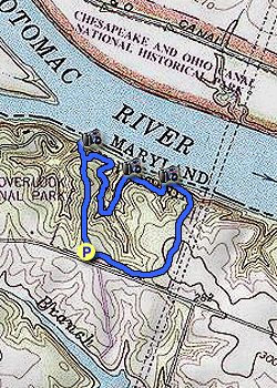
At only 67 acres Red Rock Wilderness Overlook is one of the smallest regional parks along the banks of the Potomac River, and just down the river from Balls Bluff Battlefield. With very little elevation gain this short circuit trail is perfect for young children. At the north section of the park on the banks of the Potomac there are expansive views of the river and Harrison Island, and some of the best views of the river from the cliff section on the parks southern end.
  • Parking Area - Suitable for 20 vehicles off Edwards Ferry Road NE

  • Restored Ice House - One of the four ruins on the park grounds with informational signage

  • Banks of the Potomac River - View upstream westward of the Potomac River and Harrison Island

  • Potomac Heritage Trail - View of the Potomac River from the trail

  • Cliff Views- Panoramic view of the Potomac River

Explore 38 trails near Leesburg, VA
  1. Parking

    39.112988, -77.510108
  2. Main Trailhead

    39.112988, -77.510108
No community routes found. To add your own hike as a Community Route for this Trail guide, leave a Trip Report with an attached GPX file.

Hazards

Ticks - Lyme Disease More Info (CDC)
Snakes
Poison Ivy/Oak

Seasons

All

Photo Albums

+ Add Photo Album

Upload your photos from the trail to help others know what to expect.

Trip Reports (Reviews)

Rated 3.0 out of 5 based on 2 ratings.
By: Jeff P
1.5 miles / 2.4 km
April 02, 2017
A nice hike close to town. Great for kids but not suitable for strollers. If you are looking for solitude I would not recommend this hike. However, if you want a place close to home with a little bit of up and down and not a lot of time to hike this would work nicely.
Legacy Review
By: Brian S
1.5 miles / 2.4 km
January 13, 2017
Pleasant hike, well marked. Mostly thru the woods on a nice loop but one section along the Potomac to a nice view on the Northeast corner (I think) of the property. Went out on an overcast day with the dogs and didn't see anyone else on the trail. There was only one car in the parking lot when I got there and they were gone when I got back so we apparently hiked in the same direction. Fall or Spring would make this a better hike but if you are in the area this and Balls Bluff are a couple short hikes with nice views to take in.
Legacy Review

Weather Forecast

In Leesburg, VA

Explore Hiking Trails

You May Also Like

New York's Best Waterfalls - Whether you're planning a day hike, roadside stop, or a leisurely short walk, this guide provides hikers, travelers, and locals alike with 63 different locations to over 100 scenic waterfalls to help plan your next adventure!
Explore

New York's Best Waterfalls

Whether you're planning a day hike, roadside stop, or a leisurely short walk, this guide provides hikers, travelers, and locals alike with 63 different locations to over 100 scenic waterfalls to help plan your next adventure!

Read
25 Best Day Hikes in North Carolina - Discover the top 25 best day hikes in North Carolina, from breathtaking waterfalls to mountain peaks. Explore hidden gems, scenic views, and trails suitable for all skill levels, perfect for your next outdoor adventure.
Explore

25 Best Day Hikes in North Carolina

Discover the top 25 best day hikes in North Carolina, from breathtaking waterfalls to mountain peaks. Explore hidden gems, scenic views, and trails suitable for all skill levels, perfect for your next outdoor adventure.

Read

Before you boogie...

Find our trail guides useful? Consider becoming a Supporter to unlock perks!

MyHikes is an indie platform that makes exploring public trails easier for everyone. The platform has no investors, no ads, and is owned and operated by one person, Dave Miller. Dave has personally mapped and written over 1,800 trail guides on MyHikes for the public to explore. MyHikes has helped millions outdoor enthusiasts plan their next adventure.

But it takes a lot of time 🕦, money 💰, work, and espresso shots ☕ to run MyHikes, including hiking , mapping , writing , and publishing new trails with high-quality (accurate) information... along with software engineering (coding) the platform like building new features, website and mobile app development (iOS and Android), site maintainance . and much much more.

Supporters unlock website and mobile app perks with an annual one-time payment of $25 (you renew) 😎👍. Or you can simply make a Donation of your choice. Otherwise, you can support us by telling your friends about MyHikes - both quick and free 🎉

Admin user profile picture

Dave Miller
MyHikes Founder