Loading...

🎉 Enjoy a Free 7-Day Supporter Trial and Unlock Exclusive Perks — No Credit Card Required. Learn more.

Reading Pagoda Trail

Directions
Map
Pictures
Send to App
Distance:
1.7 Miles / 2.7 km
Type:
Out-and-Back
Difficulty:
Moderate
Time to Hike:
~51 minutes
Features:
Surface Type:
Dirt
Park:
Mount Penn Preserve
Town:
Reading, Pennsylvania
Directions:
40.33815, -75.910077
Added:
April 19, 2025
Updated:
May 08, 2025
Copy Trail Link Hiking this trail? Send a friend or family member a link to this trail guide for your own safety. Hike at your own risk (disclaimer)
Loading...
Loading...
342'

Total Change
368'

Ascent
368'

Descent

Download the Trail Route for Offline Use

Supporters get exclusive access to download trail routes to the MyHikes app for offline use. Stay prepared on your adventure, even without an internet connection! Become a Supporter today to unlock this feature and hike with confidence.

Send to App

Reading Pagoda Trail

The Reading Pagoda Trail at 
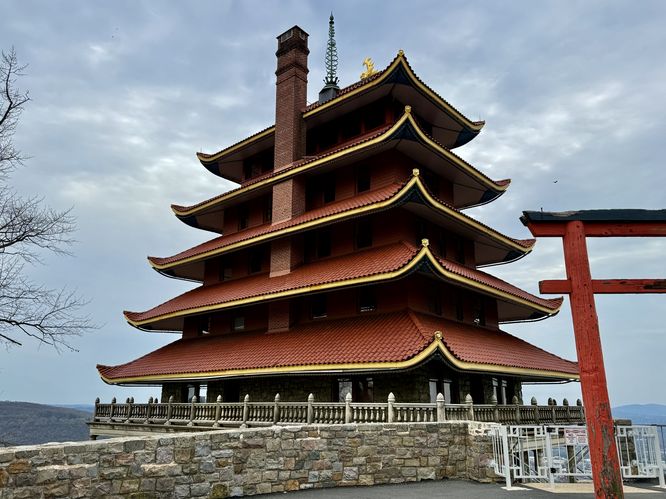
Mount Penn Preserve in Reading, Pennsylvania is a moderate 1.7-mile out-and-back hike that leads up to the area's most-photographed building, the Reading Pagoda.

Hiking to the Reading Pagoda

While most visitors will simply drive up to the pagoda, this hike follows a less-traveled path that leads you to Reading's most-iconic building without dealing with really any people along the way.

The hike begins at the very end of Walnut Street where you'll find on-street parking and signage for the Mount Penn Preserve. The Pagoda Trail leads uphill along a wide gravel path that leads up Mount Penn behind a busy neighborhood. There are several older trails that do not appear to be maintained anymore, so to stay on-trail just keep following the widest gravel path uphill. You know you're on the right trail if you pass a large grassy opening with a small building near its edge.

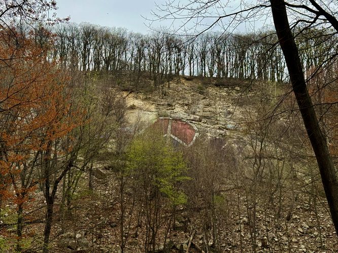
Peace Rock - Mile 0.37

Just up the hill from the large grassy opening is a right-hand turn that heads toward a sloped cliff face to the east. You'll find a massive painted peace sign on the side of the cliff face known as Peace Rock.

Base of the Pagoda & Views - Mile 0.8

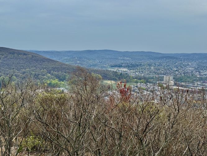
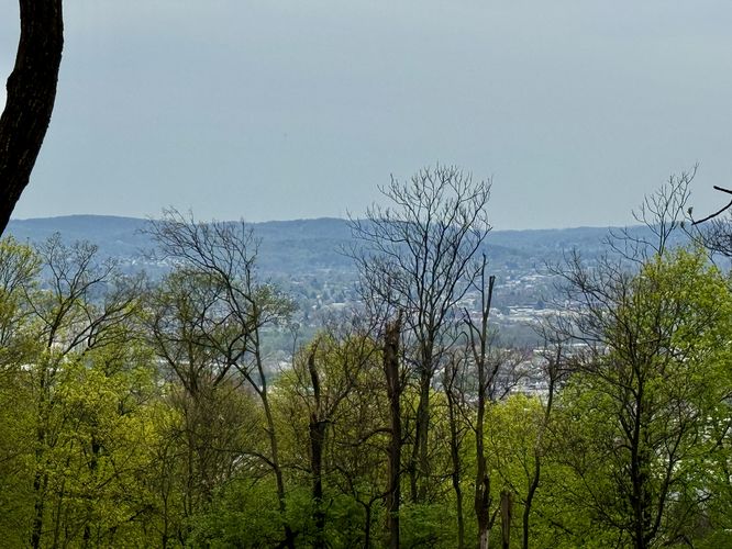
From Peace Rock, the trail leads uphill through the mountain laurel to reach the pagoda. You know you're getting close once the Reading Pagoda (aka Mount Penn Pagoda) starts to peek through the mountain laurel while you're hiking the trail. Eventually, the trail reaches the base of the retaining wall for the pagoda's parking lot. Here, the route leads out to the base of the pagoda to views of Reading, Pennsylvania. You'll also find Neversink Mountain located to the south. Neversink Mountain is a great hike as it provides views of Mount Penn and the Reading Pagoda. This section of the trail can be a bit sketchy if you're hiking with small children or a dog, however, as there are a ton of broken bottles and shattered glass around the concrete platforms.

Exploring the Pagoda & Views - Mile 0.9

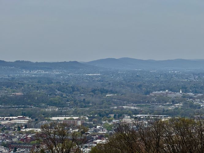
While you cannot enter the Reading Pagoda, you can walk up to the outside of the building. The trail itself does not have an easy connection to the parking lot, so you must hike off-trail for less than ~50-feet and hop a fence to reach the parking lot. Then you can walk up to the building to take your photos or to simply enjoy its architecture. You can also get views of Reading, PA and Neversink Mountain from the parking lot as well.

Hiking Out - Mile 0.9 to 1.7

Once you're done exploring the Reading Pagoda atop of Mount Penn, the hike back to parking is straight forward. Simply follow the same route back to Walnut Street to complete the hike for approximately 1.7-miles.

Parking

Hikers will find street parking at the coordinates provided, located at the very end of Walnut Street in Reading, PA.

Biking

Mountain biking is technically allowed along this route.

Warning

Broken glass: The trail around the bottom of the Reading Pagoda is littered with broken glass, so watch your step especially with children or dogs.
Explore 12 trails near Reading, PA
  1. Parking

    40.33815, -75.910077
  2. Main Trailhead

    40.338138, -75.909649
  3. View of Peace Rock

    40.342097, -75.906922
    View of Peace Rock
  4. View of Reading, PA and Neversink Mountain (left) from the Mount Penn Pagoda

    40.336136, -75.9058
    View of Reading, PA and Neversink Mountain (left) from the Mount Penn Pagoda
  5. View of distant mountains above Reading, PA as seen from the Mount Penn Pagoda

    40.336156, -75.905786
    View of distant mountains above Reading, PA as seen from the Mount Penn Pagoda
  6. Mount Penn Pagoda

    40.336231, -75.905419
    Mount Penn Pagoda
  7. Obstructed view of Reading, PA from the trail

    40.342133, -75.907706
    Obstructed view of Reading, PA from the trail
No community routes found. To add your own hike as a Community Route for this Trail guide, leave a Trip Report with an attached GPX file.

Hazards

Ticks - Lyme Disease More Info (CDC)
Poison Ivy/Oak

Seasons

All

Trip Reports

Trail Guide By:
Admin user profile picture
1.7 miles / 2.7 km
1.7 miles / 2.7 km
April 19, 2025
Mostly an easy hike up to the pagoda. The trail doesn't lead to the main parking lot which means you need to hop the fence if you want views of the entire building. Watch for broken glass along the trail near the pagoda especially if hiking with dogs or little kids.
Hiking

Weather Forecast

In Reading, PA

Explore Hiking Trails

You May Also Like

Colorado's Million Dollar Highway - Plan a day's drive adventure along the iconic Million Dollar Highway in Colorado. Explore the best short trails, roadside stops, waterfalls, vistas, ghost towns, and hot springs within a ~6 hour road trip.
Explore

Colorado's Million Dollar Highway

Plan a day's drive adventure along the iconic Million Dollar Highway in Colorado. Explore the best short trails, roadside stops, waterfalls, vistas, ghost towns, and hot springs within a ~6 hour road trip.

Read
New York's Best Waterfalls - Whether you're planning a day hike, roadside stop, or a leisurely short walk, this guide provides hikers, travelers, and locals alike with 63 different locations to over 100 scenic waterfalls to help plan your next adventure!
Explore

New York's Best Waterfalls

Whether you're planning a day hike, roadside stop, or a leisurely short walk, this guide provides hikers, travelers, and locals alike with 63 different locations to over 100 scenic waterfalls to help plan your next adventure!

Read

Before you boogie...

Find our trail guides useful? Consider becoming a Supporter to unlock perks!

MyHikes is an indie platform that makes exploring public trails easier for everyone. The platform has no investors, no ads, and is owned and operated by one person, Dave Miller. Dave has personally mapped and written over 1,800 trail guides on MyHikes for the public to explore. MyHikes has helped millions outdoor enthusiasts plan their next adventure.

But it takes a lot of time 🕦, money 💰, work, and espresso shots ☕ to run MyHikes, including hiking , mapping , writing , and publishing new trails with high-quality (accurate) information... along with software engineering (coding) the platform like building new features, website and mobile app development (iOS and Android), site maintainance . and much much more.

Supporters unlock website and mobile app perks with an annual one-time payment of $25 (you renew) 😎👍. Or you can simply make a Donation of your choice. Otherwise, you can support us by telling your friends about MyHikes - both quick and free 🎉

Admin user profile picture

Dave Miller
MyHikes Founder