-
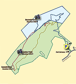
Mile 0.0 – Park at the Read Mountain Preserve parking area. Paper maps are available at the trailhead kiosk. Begin the hike by following the Buzzards Rock Trail (blue blaze) parallel to a dry gorge.
-
Mile 0.4 – Switchback away from the dry gorge.
-
Mile 0.6 – T-junction with the Rocky Way Trail (yellow blaze) on the left.
-
Mile 0.8 – Y-junction with an unmarked manway on the right. The trail switchbacks sharply to the left.
-
Mile 1.0 – Y-junction with an unmarked manway on the right.
-
Mile 1.4 – Y-junction with the Crossover Trail (red blaze) on the left.
-
Mile 1.6 – Turn right on the Buzzards Rock Trail at a Y-junction with the CCC Trail.
-
Mile 1.8 – The Buzzards Rock Trail ends at Buzzards Rock. There are multiple rock outcrops along this stretch of trail with views west of the Roanoke Valley. The large rounded peak due west is Fort Lewis Mountain and the prominent pyramidal peak towards the northwest is McAfee Knob.
-
Mile 1.9 – Continue on the CCC Trail (orange blaze) for the loop hike described here. The CCC Trail follows the ridgeline of Read Mountain with little elevation change. There may be good winter views on this trail as the forests are dominated by deciduous trees.
-
Mile 2.3 – Boulder Point on the left side of the trail. This collection of boulders offers no view.
-
Mile 2.8 – After a steep descent, take a sharp left onto the Rocky Way Trail (yellow blaze) at a Y-junction with an access road.
-
Mile 2.85 – Continue left on the Rocky Way Trail at a Y-junction with an access road. The Rocky Way Trail passes through steep rockslide areas and hardwood forests.
-
Mile 4.0 – T-junction with the Crossover Trail on the left. On the right immediately before the trail junction is Devil’s Drop, a steep rock face with views southeast of the Blue Ridge Mountains surrounding the eastern Roanoke region.
-
Mile 4.2 – Rocky Way Trail ends at a Y-junction with the Buzzards Rock Trail. Turn right to return to the parking area.
-
Mile 4.6 – Hike ends at the Read Mountain Preserve parking area.
- Distance
- 4.7 mi
- Difficulty
- Moderate
- Type
- Loop
- Est. Time
- 2.4 hrs
- Elev. Gain
- 1,321'
- Rating
- 0.0
- Added
- April 03, 2025
- Updated
- April 06, 2025
Weather Forecast
Don't let Google decide who you trust.


<strong>Trail map and elevation chart not rendering in print mode?</strong> Simply scroll to the trail map section, then try printing again!
281 m
403 m
402 m
Features
- Vista / Lookout Point
- Dogs
Points of interest
-
Parking
37.334786, -79.890528 -
Main Trailhead
37.334917, -79.89054
Safety information
For your own safety: plan ahead, let someone know where you'll be, and hike at your own risk.
Hazards
Availability
Surface type
Trip Reports (Reviews)
Ready to help fellow hikers? Add a trip report to share your experience!


You may also like

25 Best Day Hikes in Virginia
Explore the top hikes in Virginia, from iconic trails in Shenandoah National Park to hidden gems in the Blue Ridge Mountains. Find your next unforgettable outdoor adventure.

25 Best Day Hikes in West Virginia
Discover 25 of the best day hikes in West Virginia, from scenic overlooks to wilderness trails—perfect for every level of hiker.

25 Best Day Hikes in North Carolina
Discover the top 25 best day hikes in North Carolina, from breathtaking waterfalls to mountain peaks. Explore hidden gems, scenic views, and trails suitable for all skill levels, perfect for your next outdoor adventure.

Best of the Alps: Hiking, Adventure & Scenery
Plan your ultimate European Alps adventure! Discover the best hiking trails, epic scenery, and villages in the Swiss Alps, Dolomites, Chamonix, and Lake Como.

