The Raven Trail at Ravensburg State Park near Jersey Shore, Pennsylvania is an easy 1.4-mile out-and-back trail that runs the entire length of the park, passing through red pine forests and includes views of beautiful small waterfalls that cascade into blue-tinted pools of Rauchtown Creek - one of which is nicknamed Blue-Pool Falls.
Hike Description
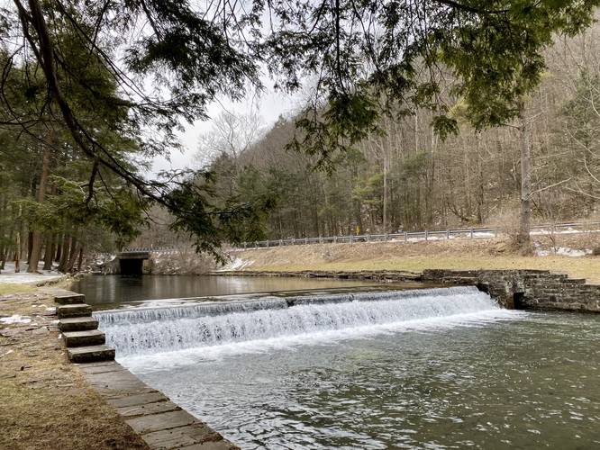
This trail begins at the southern terminus for the Raven Trail at the southern end of the park and heads north along Rauchtown Creek. Hikers will pass two small human-made waterfalls that cascade down the creek - just north of these waterfalls is a small footbridge that crosses the creek. The main path for the trail continues along the eastern shore of the creek and heads north through a beautiful red pine forest.
Blue-Pool Falls - Mile 0.36
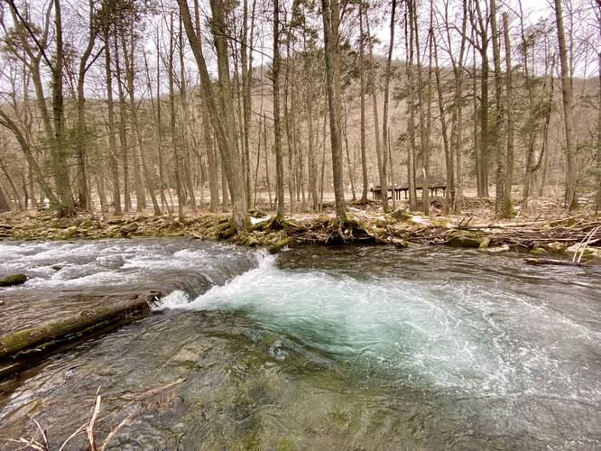
Just beyond the red pine forest is yet another footbridge that crosses the creek. Here, if the hiker stays on the east side of the creek and continues along a bushwhack for ~150-feet, they'll find a beautiful small waterfall - no taller than 1-foot tall and 10-feet wide, that cascades down the creek into a deep pool where the water swirls a light-blue color. This small cascade is well-worth the stop along this hike. Without a name, I decided to nickname this waterfall Blue-Pool Falls. Please note that this extra bushwhack hike off-trail is not shown on this trail map, but the waterfall is listed.
After passing Blue-Pool Falls, the trail will meander its way north, as it crosses Rauchtown Creek a couple of times over scenic footbridges. The trail eventually passes the main park entrance road, before reaching campsites where it terminates. At the campsites, the trail ends and hikers can start their journey back either along the trail or the road; however, the trail is far more scenic along Rauchtown Creek, making for a 1.4-mile out-and-back hike.
Parking
Hikers will find parking at the main entrance for the park, locate just over the main bridge that crosses Rauchtown Creek. This parking marker is located further south in the park. We hiked this in early March 2022 and the winter maintenance ended at this 2nd parking lot in the southern end of the park; however, during warm months, there's another parking lot located at the trailhead listed here.
Pets
Dogs are allowed if leashed and their waste should be carried out by the hiker.
Camping
Campers and car-campers will find plenty of paid-for first-come first-serve campsites at Ravensburg State Park. It's unclear if these campsites are closed in the winter or not - please follow all state park rules when camping.
Blaze Color
The Raven Trail follows red blazes. Eventually the trail will also follow red and orange blazes - the orange blazes are for the Mid State Trail (MST).
Hike Description
This trail begins at the southern terminus for the Raven Trail at the southern end of the park and heads north along Rauchtown Creek. Hikers will pass two small human-made waterfalls that cascade down the creek - just north of these waterfalls is a small footbridge that crosses the creek. The main path for the trail continues along the eastern shore of the creek and heads north through a beautiful red pine forest.
Blue-Pool Falls - Mile 0.36
Just beyond the red pine forest is yet another footbridge that crosses the creek. Here, if the hiker stays on the east side of the creek and continues along a bushwhack for ~150-feet, they'll find a beautiful small waterfall - no taller than 1-foot tall and 10-feet wide, that cascades down the creek into a deep pool where the water swirls a light-blue color. This small cascade is well-worth the stop along this hike. Without a name, I decided to nickname this waterfall Blue-Pool Falls. Please note that this extra bushwhack hike off-trail is not shown on this trail map, but the waterfall is listed.
After passing Blue-Pool Falls, the trail will meander its way north, as it crosses Rauchtown Creek a couple of times over scenic footbridges. The trail eventually passes the main park entrance road, before reaching campsites where it terminates. At the campsites, the trail ends and hikers can start their journey back either along the trail or the road; however, the trail is far more scenic along Rauchtown Creek, making for a 1.4-mile out-and-back hike.
Parking
Hikers will find parking at the main entrance for the park, locate just over the main bridge that crosses Rauchtown Creek. This parking marker is located further south in the park. We hiked this in early March 2022 and the winter maintenance ended at this 2nd parking lot in the southern end of the park; however, during warm months, there's another parking lot located at the trailhead listed here.
Pets
Dogs are allowed if leashed and their waste should be carried out by the hiker.
Camping
Campers and car-campers will find plenty of paid-for first-come first-serve campsites at Ravensburg State Park. It's unclear if these campsites are closed in the winter or not - please follow all state park rules when camping.
Blaze Color
The Raven Trail follows red blazes. Eventually the trail will also follow red and orange blazes - the orange blazes are for the Mid State Trail (MST).