The Rapid Run Foot Path at Sand Bridge State Park near Mifflinburg, Pennsylvania is an easy 0.1-mile out-and-back trail that features a small waterfall within Rapid Run and is the only trail within the park.
Exploring Sand Bridge State Park
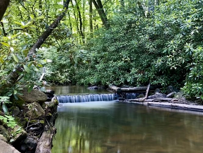
Visitors will find Sand Bridge State Park is a hidden gem located in the middle of Bald Eagle State Forest that provides visitors with a picnic area and a small foot path that connects both parking lots. Along the foot path is a bridge that spans Rapid Run where you'll find a tiny (1-foot tall) waterfall that creates a beautiful pool of water, surrounded by very-old evergreen rhododendrons. The trail then leads uphill, passing another picnic area, before it heads back to the southern trailhead. While this trail is very short, it's a great spot to stretch your legs along a backwoods Pennsylvania road trip or to take-in the scenic views of Rapid Run.
Nearby Hikes
While in the area, you might want to explore more trails near Mifflinburg, PA like the Lakeside Trail at Raymond B. Winter State Park.
Parking
Visitors will find a large parking turnout located at the coordinates provided (40.987196, -77.12662) on the north side of
Buffalo Road (PA-192). The turnout is large enough to fit a dozen vehicles as of July 2024.
Pets
Dogs are allowed if leashed and must be cleaned up after.
Restrooms
As of July 2024, the northern parking lot appears to have public restrooms but they might be pit toilets (non-flush).
Exploring Sand Bridge State Park
Visitors will find Sand Bridge State Park is a hidden gem located in the middle of Bald Eagle State Forest that provides visitors with a picnic area and a small foot path that connects both parking lots. Along the foot path is a bridge that spans Rapid Run where you'll find a tiny (1-foot tall) waterfall that creates a beautiful pool of water, surrounded by very-old evergreen rhododendrons. The trail then leads uphill, passing another picnic area, before it heads back to the southern trailhead. While this trail is very short, it's a great spot to stretch your legs along a backwoods Pennsylvania road trip or to take-in the scenic views of Rapid Run.
Nearby Hikes
While in the area, you might want to explore more trails near Mifflinburg, PA like the Lakeside Trail at Raymond B. Winter State Park.
Parking
Visitors will find a large parking turnout located at the coordinates provided (40.987196, -77.12662) on the north side of
Buffalo Road (PA-192). The turnout is large enough to fit a dozen vehicles as of July 2024.
Pets
Dogs are allowed if leashed and must be cleaned up after.
Restrooms
As of July 2024, the northern parking lot appears to have public restrooms but they might be pit toilets (non-flush).