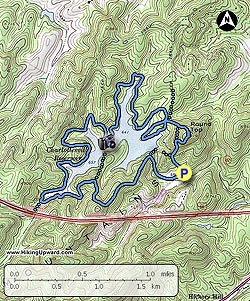
Over 4 miles of the trail are shoreline. There are a couple of good climbs but overall this is a fairly easy and pleasant hike.
This hike can be done in either direction. We did it counter-clockwise, with the trail starting just to the right of the kiosk at the end of the parking area. The trails are well signed at intersections and with some blue blazes.
-
Mile 0.0 - Begin a short tough climb, bear right at the top.
-
Mile 0.3 - The Round Top Trail intersection is on the right, stay straight on the Ragged Mtn Trail.
-
Mile 0.6 – Intersection and Mountain Man Statue, bear to the right following sign for Upper Loop Trail
-
Mile 0.9 – Water Tower, bear to the left of water tower.
-
Mile 1.1 – Reach intersection with Bear Statue, bear to the right onto Trail.
-
Mile 1.6 – Eagle Statue, cross small bridge is just beyond the statue.
-
Mile 2.1 – Upper Loop comes in on the right, stay straight. In less than 100 yards you will see the brick outline of the Sugar Hollow Reservoir pipe tunnel.
-
Mile 3.3 – Bear left onto the Old Upper Dam Road.
-
Mile 4.6 – Floating Bridge, I-64 is visible on your right as you cross the bridge.
-
Mile 4.8 – Intersection with Peninsula Trail, we bypassed this, this trail takes you to the remnants of the old Upper Reservoir Dam. Prior to 2014 there were 2 reservoirs.
-
Mile 5.8 – Arrive at new dam. Cross dam then cross road to reach trail to return to parking lot.
-
Mile 6.0 – Parking Lot.
Photo Note: We have left some of the photos from our original 2011 posting of Ragged Mountain prior to the expansion of the reservoir. There are no longer 2 lakes, the upper dam is gone, the upper dam Pump House is gone and the chimney ruins are also gone.