Loading...

Distance:
0 Miles / 0 km
Type:
Out-and-Back
Difficulty:
Easy
Time to Hike:
~5 minutes
Features:
Surface Type:
Dirt
Town:
Honokohau, Hawaii
Directions:
21.021979, -156.6234
Added:
February 17, 2023
Updated:
February 24, 2023
Please consider making a donation to the Maui Strong Fund to help the victims of Hawaii's recent wildfires.
Loading...
Loading...
28 '

Total Change
0 '

Ascent
0 '

Descent

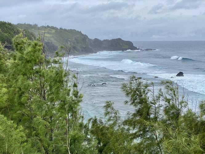
The Punalau Lookout near Honokohau, Hawaii (Maui) is a quick roadside lookout that features views of Maui's northern coastline.

This is not a hike or a walk, but instead requires a couple of steps out of your vehicle to enjoy this nice lookout. From the lookout, visitors get an obstructed view of Punalau Beach alongside Maui's rugged cliffs.

Parking
There's a very small parking turnout at the coordinates provided, large enough to fit no more than 2 vehicles.

Pets
Dogs are allowed if leashed and cleaned up after.

Warning
Steep cliffs: Watch your step as the terrain near the lookout can be very steep.

Respecting the Land
Hawaiian land is considered sacred to native Hawaiians and many locals, so please stay on-trail, take nothing but photos, and leave nothing but footprints. Respect the locals - don't stay for long and have a backup hike planned in case the parking lot is full.

Explore 40 trails near Honokohau, HI
  1. Parking

    21.021979, -156.6234
  2. Main Trailhead

    21.022069, -156.623497
  3. Punalau Lookout

    21.022159, -156.623599
    Punalau Lookout
No community routes found. To add your own hike as a Community Route for this Trail guide, leave a Trip Report with an attached GPX file.

Hazards

Rockfalls / Ledges / or Scrambles

Seasons

All

Photo Albums

1 Trip Report

No Star-Ratings
Write-up by:
Admin user profile picture
0 miles / 0 km
Trail added
February 17, 2023
Hiked on
February 17, 2023
Updated on
February 24, 2023

Weather Forecast

In Honokohau, HI

Explore Hiking Trails

New Hikes

Cottonwood Falls Loop
1.2 Miles
1.9 km
Moderate
Loop
Bates Ferry Trail and General Greene Tree
2.7 Miles
4.3 km
Easy
Out-and-Back
Eternal Flame Falls via Eternal Flame Trail
1.2 Miles
1.9 km
Moderate
Out-and-Back
Tibwin Plantation Trail
1.9 Miles
3.1 km
Easy
Out-and-Back

Before you leave...

MyHikes is an indie web platform aimed to make exploring public trails easier for everyone. The site has no investors and is owned and operated by one person, Dave Miller (Founder & Admin). As the Founder, main contributor, and doer-of-all-things for MyHikes, I share my trips with over-detailed write-ups for fun on a volunteer basis and I believe that public trail information should be available to everyone.

It takes a lot of time 🕦, money 💰, and effort (including espresso shots ☕) to run MyHikes, including hiking , mapping , writing , and publishing new trails with high-quality content... along with building new features, moderating, site maintainance, and app development for iOS and Android . I simply ask that if you find MyHikes' trail guides helpful to please consider becoming a Supporter to help keep the site, iOS, and Android apps available to everyone.

Supporters unlock website and in-app perks with a one-time payment of $25 (you renew) 😎👍. Or you can simply make a Donation of your choice without a MyHikes user account. Otherwise, telling your friends about MyHikes is the next-best thing - both quick and free 🎉

Thanks for visiting MyHikes and have a great hike!️

Admin user profile picture

Dave Miller
MyHikes Founder & Admin