Loading...

🌲 WINTER SALE! 50% OFF on Supporter Accounts — now through December 31st. Unlock a full year of exclusive website & app perks for better hikes. Learn More.

Puflerbach Falls

Directions
Map
Pictures
Download Puflerbach Falls GPX Data to the MyHikes Mobile App
Distance:
0.2 km / 0.1 Miles
Type:
Out-and-Back
Difficulty:
Easy
Time to Hike:
~10 minutes
Features:
Surface Type:
Dirt
Town:
Ortisei, Italy
Get Directions:
46.568548, 11.643308
Added:
September 25, 2025
Updated:
November 23, 2025
Copy Trail Link Hiking this trail? Send a friend or family member a link to this trail guide for your own safety. Hike at your own risk (disclaimer)
Loading...
Loading...
10m

Total Change
10m

Ascent
10m

Descent

Download the GPX Data for Offline Use

Supporters get exclusive access to download trail routes to the MyHikes app for offline use. Stay prepared on your adventure, even without an internet connection! Become a Supporter today to unlock this feature and hike with confidence.

Download Puflerbach Falls GPX Data to the MyHikes Mobile App

Key Takeaways

  • The Puflerbach Falls offer a beautiful, multi-tiered cascade directly accessible from Streda Pineies in Ortisei, Val Gardena. It's considered one of the most accessible natural attractions in the Dolomites region.
  • This trail is an ultra-short, easy 0.15 km (0.1 mile) out-and-back walk, making it perfect for families, travelers short on time, or anyone seeking a high-reward natural viewing experience without the commitment of a strenuous hike.
  • Visitors will find a small parking turnout (capacity for 2-3 cars) located directly at the trailhead along Streda Pineies (46.568548, 11.643308), ensuring a very short transition from car to cascade viewing.

Puflerbach Falls

Looking for a beautiful waterfall walk in the heart of the Dolomites without committing to a long hike? The Puflerbach Falls walk near Ortisei is a perfect place to relax and enjoy a series of cascading waterfalls.

Located along Streda Pineies, this easy, 0.15 km (0.1 mile) out-and-back trail is less of a trek and more of a delightful five-minute detour that instantly rewards you with scenic cascades. Discover the rushing waters of the Puflerbach stream as they tumble down a series of magnificent waterfalls, creating a tranquil, picture-perfect setting. Ideal for families, travelers with limited time, or anyone looking for a quick dose of stunning natural beauty in Val Gardena, this short walk delivers maximum impact for minimum effort. Simply park at the small turnout (check your map for coordinates) and prepare to be enchanted by one of Ortisei's most accessible hidden gems.

Puflerbach Falls Trail Guide: A Quick Scenic Cascade in Ortisei

This short walk to Puflerbach Falls begins along Streda Pineies in Ortisei, Italy where you'll find a small parking turnout and trailhead on the southwest side of the road. The trail leads in from the road and hits a fork where hikers can choose to head up the mountainside for a longer day hike or take a left-hand turn to reach Puflerbach (Pufler Stream). This route heads directly to Puflerbach and its series of waterfalls.

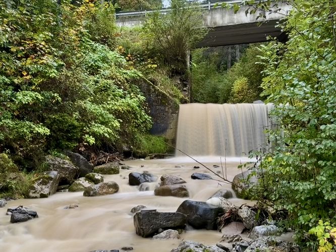
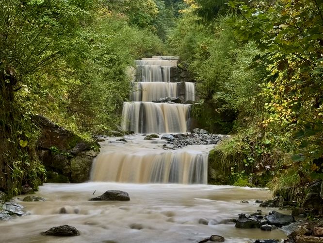
After walking just a few meters from the parking turnout, you'll reach the side of Puflerbach's rushing water as it cascades down toward the center of Ortisei. Immediately, you'll find a multitude of small waterfalls, approximately 5-feet tall each, that spill down the mountainside along steps. Following the trail downhill, crossing under the Streda Pineies bridge, you'll find even more waterfalls, including a slightly-larger cascade. Some of the most scenic waterfall viewpoints sit on the north side of Streda Pineies bridge where you'll find a series of at least six tumbling waterfalls.

After you're done exploring the cascades of Puflerbach, the walk back to parking wraps up this very short, but easy 0.15 km out-and-back walk.

Getting to Puflerbach Falls in Ortisei (The Trailhead & Parking)

Visitors to Puflerbach Falls will find a small parking turnout at the coordinates provided (46.568548, 11.643308), located on the southwest side of Streda Pineies near Ortisei. The turnout is large enough to fit at most 2 or 3 vehicles as of September 2025. If you plan to take public transportation, like the local bus, there's a bus stop located near the trailhead at (46.568366,11.644641) which adds just a couple of minutes to this already short walk.

Photography Tips for Capturing the Waterfall Series

For a truly stunning photograph of the Puflerbach Falls, embrace the silky water effect popular in landscape photography. Since this is a short walk, a compact tripod and a lens cloth (to wipe away mist) are your essential gear. The key is using a slow shutter speed—start at around 1/4th of a second up to two seconds—to blur the falling water into a soft, ethereal ribbon while keeping the surrounding mossy rocks and foliage of the Ortisei forest sharp. Visit on a cloudy or overcast day, or in the soft light of early morning, to avoid harsh shadows and capture the vibrant greens of the cascade's environment for a dramatic, low-contrast shot.
Explore 11 trails near Ortisei, Italy
  1. Parking

    46.568548, 11.643308
  2. Main Trailhead

    46.568548, 11.643308
  3. Waterfall

    46.568306, 11.643494
    Waterfall
  4. Waterfall

    46.568633, 11.643817
    Waterfall
  5. Waterfall

    46.568486, 11.643628
    Waterfall
No community routes found. To add your own hike as a Community Route for this Trail guide, leave a Trip Report with an attached GPX file.

Seasons

All

Photo Albums

+ Add Photo Album

Upload your photos from the trail to help others know what to expect.

Preview of the MyHikes mobile app interface

Track, Log, and Explore Hikes with the MyHikes App

Shop Landscape Prints
Shop our Alps landscape prints to support MyHikes!

Trip Reports (Reviews)

Ready to help fellow hikers? Add a trip report to share your experience and provide valuable insights for those planning their next hike. Your review makes the trail better for everyone.

Your opinion matters! Be the first to rate this trail.

Explore Hiking Trails

You May Also Like

Colorado's Million Dollar Highway - Plan a day's drive adventure along the iconic Million Dollar Highway in Colorado. Explore the best short trails, roadside stops, waterfalls, vistas, ghost towns, and hot springs within a ~6 hour road trip.
Explore

Colorado's Million Dollar Highway

Plan a day's drive adventure along the iconic Million Dollar Highway in Colorado. Explore the best short trails, roadside stops, waterfalls, vistas, ghost towns, and hot springs within a ~6 hour road trip.

Read
Glacier's Going-to-the-Sun Road - Discover the breathtaking beauty of Glacier National Park along the iconic Going-to-the-Sun Road. From stunning roadside stops to picturesque waterfalls and vistas, this engineering marvel offers endless opportunities for exploration.
Explore

Glacier's Going-to-the-Sun Road

Discover the breathtaking beauty of Glacier National Park along the iconic Going-to-the-Sun Road. From stunning roadside stops to picturesque waterfalls and vistas, this engineering marvel offers endless opportunities for exploration.

Read
New York's Best Waterfalls - Whether you're planning a day hike, roadside stop, or a leisurely short walk, this guide provides hikers, travelers, and locals alike with 63 different locations to over 100 scenic waterfalls to help plan your next adventure!
Explore

New York's Best Waterfalls

Whether you're planning a day hike, roadside stop, or a leisurely short walk, this guide provides hikers, travelers, and locals alike with 63 different locations to over 100 scenic waterfalls to help plan your next adventure!

Read

Before you boogie...

Find our trail guides useful? Consider becoming a Supporter to unlock perks!

MyHikes is an indie platform that makes exploring public trails easier for everyone. The platform has no investors, no ads, and is owned and operated by one person, Dave Miller. Dave has personally mapped and written over 1,800 trail guides on MyHikes for the public to explore. MyHikes has helped millions outdoor enthusiasts plan their next adventure.

But it takes a lot of time 🕦, money 💰, work, and espresso shots ☕ to run MyHikes, including hiking , mapping , writing , and publishing new trails with high-quality (accurate) information... along with software engineering (coding) the platform like building new features, website and mobile app development (iOS and Android), site maintainance . and much much more.

Supporters unlock website and mobile app perks with an annual one-time payment of $25 (you renew) 😎👍. Or you can simply make a Donation of your choice. Otherwise, you can support us by telling your friends about MyHikes - both quick and free 🎉

Admin avatar

Dave Miller
MyHikes Founder
🍪 We use cookies to learn about site usage, performance, and to serve map tiles. You may block cookies manually in the browser. By continuing to use MyHikes, you agree. Learn more