Loading...

Distance:
0 Miles / 0 km
Type:
Out-and-Back
Difficulty:
Easy
Time to Hike:
~5 minutes
Features:
Surface Type:
Universal Access
Town:
Colton, Utah
Directions:
39.810022, -110.94159
Added:
September 29, 2023
Updated:
December 08, 2023
Loading...
Loading...
3 '

Total Change
0 '

Ascent
0 '

Descent

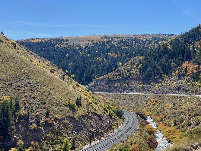
The Price Canyon Lookout near Colton, Utah is a roadside stop that features beautiful views of the Price River as it cuts through the Price Canyon.

This is not a hike but rather a quick roadside stop that features views. Visitors don't necessarily need to walk outside of their vehicle to take-in the views, unless you want to see the river as it cuts through the canyon.

Universal Access
Since visitors do not need to exit their vehicle to enjoy the views, this roadside stop should be considered universally accessible.

Parking
Visitors will find a very large parking turnout located at the coordinates provided, along US-6.

Pets
Dogs are allowed only if leashed and must be cleaned up after.

  1. Parking

    39.810022, -110.94159
  2. Main Trailhead

    39.809916, -110.941634
  3. Price Canyon Lookout

    39.809825, -110.941636
    Price Canyon Lookout
No community routes found. To add your own hike as a Community Route for this Trail guide, leave a Trip Report with an attached GPX file.

Hazards

Snakes

Seasons

All

Photo Albums

2 Trip Reports

No Star-Ratings
Write-up by:
Admin user profile picture
0 miles / 0 km
Trail added
September 29, 2023
Hiked on
September 29, 2023
Updated on
December 08, 2023
0 miles / 0 km
September 29, 2023
Hiking

Weather Forecast

In Colton, UT

Explore Hiking Trails

New Hikes

Forty Acre Rock Trail
1.4 Miles
2.3 km
Easy
Out-and-Back
Upper Rattler Run Falls
1.9 Miles
3.1 km
Hard
Out-and-Back
Lehigh Gap Ridge via Appalachian Trail
2.5 Miles
4 km
Hard
Loop
Timmerman Trail
1.2 Miles
1.9 km
Easy
Out-and-Back

Before you leave...

MyHikes is an indie web platform aimed to make exploring public trails easier for everyone. The site has no investors and is owned and operated by one person, Dave Miller (Founder & Admin). As the Founder, main contributor, and doer-of-all-things for MyHikes, I share my trips with over-detailed write-ups for fun on a volunteer basis and I believe that public trail information should be available to everyone.

It takes a lot of time 🕦, money 💰, and effort (including espresso shots ☕) to run MyHikes, including hiking , mapping , writing , and publishing new trails with high-quality content... along with building new features, moderating, site maintainance, and app development for iOS and Android . I simply ask that if you find MyHikes' trail guides helpful to please consider becoming a Supporter to help keep the site, iOS, and Android apps available to everyone.

Supporters unlock website and in-app perks with a one-time payment of $25 (you renew) 😎👍. Or you can simply make a Donation of your choice without a MyHikes user account. Otherwise, telling your friends about MyHikes is the next-best thing - both quick and free 🎉

Thanks for visiting MyHikes and have a great hike!️

Admin user profile picture

Dave Miller
MyHikes Founder & Admin