Powder Hill Tower via Ice Age Trail at Kettle Moraine State Forest near Slinger, Wisconsin is a moderate 1.5-mile out-and-back hike that leads to the top of the Powder Hill Tower and features views of Pike Lake and the surrounding area.
Trails
This hike follows the Ice age Trail (yellow blazes) and an unnamed spur trail that leads to the tower. For the best directions, follow the tower symbols on each trail post at each junction, as of September 2022.
Hike Description
This hike begins at the Pike Lake Segment for the Ice Age Trail at the parking coordinates provided and follows the Ice Age Trail heading south from the parking lot. Not long after hiking the Ice Age Trail, the path will cross Powder Hill Road at a crosswalk. After passing through an open field area, the trail will meet yet another junction, around mile 0.22 - stay left here to continue hiking toward Powder Hill Tower.
Powder Hill Tower Spur Trail - Mile 0.45
Around mile 0.45, hikers will reach a left-hand turn where a spur trail leads up Powder Hill and to the observation tower. This is where hikers will leave the Ice Age Trail. The trail leading to the tower is easy to follow - just hike along the widest path and skip the off-trail unofficial paths that people have created over the years.
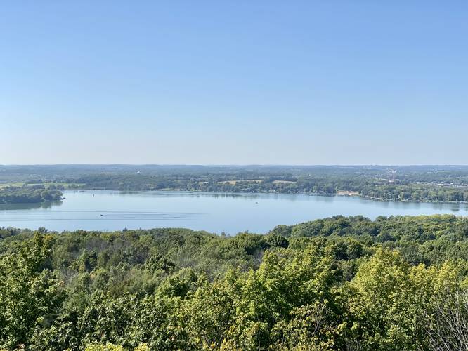
Powder Hill Observation Tower - Mile 0.7
At mile 0.7, hikers will reach the Powder Hill Observation Tower, which was donated in October 2001 by Richard and Marlene Lee. The tower is about 70-feet tall and features views from the top, including that of the neighboring Pike Lake. After enjoying the views, hikers can take the same, but opposite route back to parking for a ~1.5-mile out-and-back hike.
Parking
Hikers will find a large parking lot at the coordinates provided at the Pike Lake Segment for the Ice Age Trail. The lot is large enough to fit a couple dozen vehicles as of September 2022.
Pets
Dogs are allowed if leashed and their waste must be carried out by the hiker. Dogs are not allowed on the tower.
Pike Lake Unit Map PDF
Please find the official Pike Lake Unit Trail Map PDF for more route details.
Trails
This hike follows the Ice age Trail (yellow blazes) and an unnamed spur trail that leads to the tower. For the best directions, follow the tower symbols on each trail post at each junction, as of September 2022.
Hike Description
This hike begins at the Pike Lake Segment for the Ice Age Trail at the parking coordinates provided and follows the Ice Age Trail heading south from the parking lot. Not long after hiking the Ice Age Trail, the path will cross Powder Hill Road at a crosswalk. After passing through an open field area, the trail will meet yet another junction, around mile 0.22 - stay left here to continue hiking toward Powder Hill Tower.
Powder Hill Tower Spur Trail - Mile 0.45
Around mile 0.45, hikers will reach a left-hand turn where a spur trail leads up Powder Hill and to the observation tower. This is where hikers will leave the Ice Age Trail. The trail leading to the tower is easy to follow - just hike along the widest path and skip the off-trail unofficial paths that people have created over the years.
Powder Hill Observation Tower - Mile 0.7
At mile 0.7, hikers will reach the Powder Hill Observation Tower, which was donated in October 2001 by Richard and Marlene Lee. The tower is about 70-feet tall and features views from the top, including that of the neighboring Pike Lake. After enjoying the views, hikers can take the same, but opposite route back to parking for a ~1.5-mile out-and-back hike.
Parking
Hikers will find a large parking lot at the coordinates provided at the Pike Lake Segment for the Ice Age Trail. The lot is large enough to fit a couple dozen vehicles as of September 2022.
Pets
Dogs are allowed if leashed and their waste must be carried out by the hiker. Dogs are not allowed on the tower.
Pike Lake Unit Map PDF
Please find the official Pike Lake Unit Trail Map PDF for more route details.