Loading...

WINTER SALE! 50% OFF Supporter Accounts — now through January 31st. Learn More.

Pleasant Grove Hike

Near Palmyra, VA is Pleasant Grove, a beautiful 969 acre property owned by Fluvanna County with significant involvement by the Fluvanna Heritage Trail Foundation. The property contains miles and miles of hiking and horse trails following creeks and the Rivanna River. The main hiking trail is the Heritage Trail which mostly follows the river.

The trails meander through gentle woodlands, fields, creeks and the river. Located about 1 hour from Richmond VA, this is a worthwhile family friendly hike with great picnic facilities at the Eastern trailhead.

We hiked the Sandy Beach wheel chair accessible trail first which then ties back in with the Heritage Trail. The 4 miles of trail prior to reaching the Pole Barns will have 17+ trail intersections. When in doubt about which way to go, follow the Heritage Trail signs/arrows/yellow blazes.

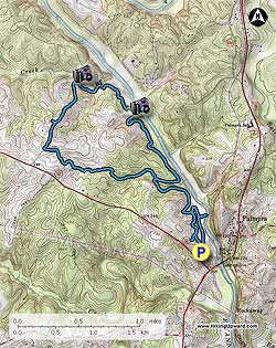
  • Mile 0.0 – The hike begins near the “Welcome Sign” at the end of the parking lot, very quickly reach Intersection 1, go right towards Sandy Beach.
  • Mile 0.4 – Intersection 2, spur trail to river and beach. Return to intersection and bear right onto the River Bluff Trail. In 0.1 miles trail bears left, heading uphill.
  • Mile 0.8 – Intersection 3, bear right onto yellow Heritage Trail(HT).
  • Mile 1.5 – Go through 5 more intersections and 2 bridges, just after the 2nd bridge  turn right onto the HT at Intersection 9 (Deep Creek Trail). The loop part of the hike will tie back into this intersection with Deep Creek Trail later in the hike.
  • Mile 1.6 – Intersection 10 (Center Hill Trail), stay straight on the HT
  • Mile 2.2 – Intersection 11, saw no named signs at this intersection but bear right and head down to creek with a broken bridge. There were “no biking” and “no horses” signs.
  • Mile 2.3 – Intersection 12 (Fern Hill Trail), stay straight on the HT. Cross 2 small bridges prior to reaching the River Bluff.
  • Mile 2.8 – River Bluff fenced area with views of the river.
  • Mile 3.0 – Intersection 13, bear to the left as indicated by arrow. I don't remember seeing named signs at this intersection.
  • Mile 3.2 – Intersection 14, bear to the left onto HT, trail is now following Burke Creek. I have a photo of the other trail names here but it turned out blurry so can't read them.
  • Mile 3.3 – Intersection 15, bear right to “Overlook”, do not head to barns yet. You will very quickly come to an overlook (more a viewing area) of Burke Creek. After going to the creek come back and bear right onto the trail, which is a shared horse trail at this point.
  • Mile 3.3 – Reach 2nd viewing area of Burke Creek. After viewing the creek bear right and in 100 feet reach Intersection 16, follow HT up to the Barns.
  • Mile 3.8 – Intersection 17 (Brush Arbor Trail), stay on the HT.
  • Mile 4.0 – Pole Barns, continue on gravel road through the middle of the barns.
  • Mile 4.1 – Cool old Chevy Dump Truck at edge of woods on the right.
  • Mile 4.3 – Fluvanna Heritage Trailhead Museum
  • Mile 4.4 – Cemetery
  • Mile 4.5 – At Paved Road, turn left towards Ballfields.
  • Mile 4.6 – At “End State Maintenance” turn 90 degrees to the right and head to trail post at edge of woods. At trail post for Rock Brook Trail, cross ditch/creek and follow trail along edge of woods
  • Mile 4.7 – Intersection 18, trail bears left into the woods. No sign here that I remember. Trail follows an unnamed creek.
  • Mile 5.4 – Intersection 19, bear left onto Beech Grove Trail.
  • Mile 5.5 – Cross creek and reach Intersection 20, bear right onto Deep Creek Trail.
  • Mile 5.6 – Intersection 21, bear right staying on Deep Creek Trail.
  • Mile 5.7 – Intersection 22, on left, bypass and then quickly turn right onto Intersection 09. You are now back on the Heritage Trail.
  • Mile 5.7 – Intersection 09. You are now back on the Heritage Trail. Stay on the HT until you reach Intersection 03 passing Intersection 08, 07, 06, 05, and 04.
  • Mile 6.3 – Intersection 03, this is the intersection you came up from earlier when you hiked the Sandy Beach trail. Do not turn left, stay on the HT.
  • Mile 6.4 – Intersection 23 (Horse Shoe Trail), stay straight on the HT.
  • Mile 6.6 – Intersection 01, bypass and head to Parking Lot.
  • Mile 6.7 – Arrive at parking area.
Explore 2 trails near Palmyra, VA

Know Before You Go

  • Pleasant Grove in Palmyra, VA, offers a 5.9-mile family-friendly hike along the Heritage Trail, featuring diverse terrain like woodlands, fields, creeks, and the Rivanna River.
  • The Heritage Trail has numerous intersections (17+ in the first 4 miles), so follow the Heritage Trail signs/arrows/yellow blazes to stay on course.
  • The hike includes notable landmarks like the Pole Barns, a Chevy Dump Truck, the Fluvanna Heritage Trailhead Museum, and a cemetery, offering a blend of natural beauty and historical points of interest.
Interactive topographic map for Pleasant Grove Hike located in Palmyra, VA. Click the "View Map" button to load GPS coordinates and trail markers.
Get directions
Distance
5.9 mi
Difficulty
Moderate
Type
Loop
Est. Time
3 hrs
Elev. Gain
615'
Rating
3.5
Added
April 03, 2025
Updated
April 06, 2025

Weather Forecast

Loading...
Total Change
167'
Ascent
615'
Descent
615'
Loading...

Download the GPX Data for Offline Use

Supporters get exclusive access to download trail routes to the MyHikes app for offline use. Stay prepared on your adventure, even without an internet connection! Become a Supporter today to unlock this feature and hike with confidence.

Download Pleasant Grove Hike GPX Data to the MyHikes Mobile App

Features

Vista / Lookout Point
Dogs
Water Source

Points of interest

  1. Parking

    37.860381, -78.270604
  2. Main Trailhead

    37.860381, -78.270604

Safety information

For your own safety: plan ahead, let someone know where you'll be, and hike at your own risk.

Hazards

Snakes (Rattlesnakes, Copperheads, others)
Poison Ivy or Poison Oak

Availability

All seasons

Surface type

Dirt

Trip Reports (Reviews)

Rated 3.5 out of 5 based on 10 ratings.

Ready to help fellow hikers? Add a trip report to share your experience and provide valuable insights for other hikers!

By: hopeful
5.9 miles / 9.5 km
February 15, 2018
We had had a lot of rain, and the trails were very swampy and muddy. We could tell the water had been flowing over the trail in some spots. We thought the walk along the river was beautiful. However, we would recommend starting the trail from the visitor center instead of the dog park so that you can get a trail map. (There may also be maps at the trail head at the dog park--we didn't think to look.) Basically it seemed like the directions were correct as far as which direction to turn. It was just the way they were written that were confusing--making it seem like you were getting off the HT trail when you were supposed to stay on it. The part about the broken bridge no longer applies as it looks like the trail has been rerouted around that spot. There was also one intersection that was not marked along Burke Creek after crossing a bridge. The trail goes straight across a river or left up a hill. It turned out up the hill was the correct one, but there were no trail markings for at least half a mile.
Legacy Review
By: Newhiker
5.9 miles / 9.5 km
April 16, 2017
My husband and I went hiking with our 20 year old son. We only saw one other group on the trail the entire time we hiked. Hike was okay not much to see. I didn't think it was very scenic. Good experience but I wouldn't go back to that trail....too many others to try.
Legacy Review
By: Suzanne
5.9 miles / 9.5 km
January 28, 2017
Hiked Pleasant Grove today with my over sixty hudsband and my son and his girlfriend (both millennials). We all loved it! Very peaceful and calm by the river, and hiked along the water for most of the hole. Trail is well marked. Muddy in a few spots. Would be beautiful in the Spring.
Legacy Review
No community routes found. To add your own hike as a Community Route for this Trail guide, leave a Trip Report with an attached GPX file.

Popular categories

Scenic mountain view representing vista trails
Vista trails
Scenic gorge of cascades representing waterfall trails
Waterfall hikes
Rugged mountain terrain representing summit trails
Summit trails
Scenic mountain view representing dog-friendly trails
Dog-friendly
Scenic campsite with a view representing camping trails
Camping trails
Appalachian Trail logo representing A.T. hikes
A.T. hikes

You May Also Like

25 Best Day Hikes in North Carolina - Discover the top 25 best day hikes in North Carolina, from breathtaking waterfalls to mountain peaks. Explore hidden gems, scenic views, and trails suitable for all skill levels, perfect for your next outdoor adventure.
Explore

25 Best Day Hikes in North Carolina

Discover the top 25 best day hikes in North Carolina, from breathtaking waterfalls to mountain peaks. Explore hidden gems, scenic views, and trails suitable for all skill levels, perfect for your next outdoor adventure.

Read
🍪 We use cookies to learn about site usage and to serve map tiles. You may block cookies manually in the browser. By continuing you agree. Learn more