Loading...

๐ŸŽ‰ Enjoy a Free 7-Day Supporter Trial and Unlock Exclusive Perks โ€” No Credit Card Required. Learn more.

Piracy Point Trail

Directions
Map
Pictures
Send to App
Distance:
0.4 Miles / 0.6 km
Type:
Out-and-Back
Difficulty:
Easy
Time to Hike:
~12 minutes
Features:
Surface Type:
Dirt
Park:
Bryce Canyon National Park
Town:
Bryce Canyon City, Utah
Directions:
37.544563, -112.247153
Added:
September 25, 2023
Updated:
October 06, 2023
Copy Trail Link Hiking this trail? Send a friend or family member a link to this trail guide for your own safety. Hike at your own risk (disclaimer)
Loading...
Loading...
3'

Total Change
5'

Ascent
5'

Descent

Download the Trail Route for Offline Use

Supporters get exclusive access to download trail routes to the MyHikes app for offline use. Stay prepared on your adventure, even without an internet connection! Become a Supporter today to unlock this feature and hike with confidence.

Send to App

Piracy Point Trail

Piracy Point at Bryce Canyon National Park near Bryce Canyon City, Utah is an easy 0.4-mile out-and-back hike that leads to the stunning overlook of the canyon named Piracy Point.

Hike
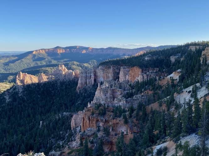
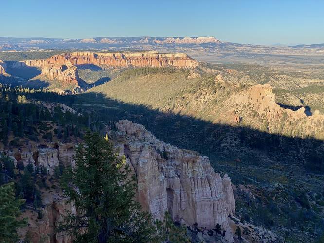
Hikers will begin this trail north of Farview Point, located essentially at the same trailhead, and hike north along the Piracy Point Trail as it meanders its way along the canyon rim to reach the overlook at the end of the trail. From Piracy Point, hikers will find sweeping views of Bryce Canyon's cliffs, rocky outcroppings, and steep canyon walls that drop hundreds of feet below. The trail has a small loop (lollipop) at the end where hikers will find views facing eastward, north, and south.

Fees
Bryce Canyon National Park has a $35/week entry fee as of September 2023. Visitors are highly encouraged to purchase an annual National Parks pass before their trip to reduce entry fees (especially if you're passing through multiple parks) and to also speed-up the very-long line that leads into the park.

Parking
Visitors will find a large parking lot at the coordinates provided.

Pets
Dogs are not allowed on this trail.
Explore 24 trails near Bryce Canyon City, UT
  1. Parking

    37.544563, -112.247153
  2. Main Trailhead

    37.544572, -112.246999
  3. View facing south from Piracy Point at Bryce Canyon National Park

    37.546017, -112.244972
    View facing south from Piracy Point at Bryce Canyon National Park
  4. View north from Piracy Point at Bryce Canyon National Park

    37.546361, -112.244553
    View north from Piracy Point at Bryce Canyon National Park
No community routes found. To add your own hike as a Community Route for this Trail guide, leave a Trip Report with an attached GPX file.

Hazards

Snakes
Rockfalls / Ledges / or Scrambles

Seasons

All

Photo Albums

Trip Reports

Trail Guide By:
Admin user profile picture
0.4 miles / 0.6 km
0.4 miles / 0.6 km
September 25, 2023
Hiking

Weather Forecast

In Bryce Canyon City, UT

Explore Hiking Trails

You May Also Like

Colorado's Million Dollar Highway - Plan a day's drive adventure along the iconic Million Dollar Highway in Colorado. Explore the best short trails, roadside stops, waterfalls, vistas, ghost towns, and hot springs within a ~6 hour road trip.
Explore

Colorado's Million Dollar Highway

Plan a day's drive adventure along the iconic Million Dollar Highway in Colorado. Explore the best short trails, roadside stops, waterfalls, vistas, ghost towns, and hot springs within a ~6 hour road trip.

Read
Glacier's Going-to-the-Sun Road - Discover the breathtaking beauty of Glacier National Park along the iconic Going-to-the-Sun Road. From stunning roadside stops to picturesque waterfalls and vistas, this engineering marvel offers endless opportunities for exploration.
Explore

Glacier's Going-to-the-Sun Road

Discover the breathtaking beauty of Glacier National Park along the iconic Going-to-the-Sun Road. From stunning roadside stops to picturesque waterfalls and vistas, this engineering marvel offers endless opportunities for exploration.

Read
New York's Best Waterfalls - Whether you're planning a day hike, roadside stop, or a leisurely short walk, this guide provides hikers, travelers, and locals alike with 63 different locations to over 100 scenic waterfalls to help plan your next adventure!
Explore

New York's Best Waterfalls

Whether you're planning a day hike, roadside stop, or a leisurely short walk, this guide provides hikers, travelers, and locals alike with 63 different locations to over 100 scenic waterfalls to help plan your next adventure!

Read

Before you boogie...

Find our trail guides useful? Consider becoming a Supporter to unlock perks!

MyHikes is an indie platform that makes exploring public trails easier for everyone. The platform has no investors, no ads, and is owned and operated by one person, Dave Miller. Dave has personally mapped and written over 1,800 trail guides on MyHikes for the public to explore. MyHikes has helped millions outdoor enthusiasts plan their next adventure.

But it takes a lot of time ๐Ÿ•ฆ, money ๐Ÿ’ฐ, work, and espresso shots โ˜• to run MyHikes, including hiking , mapping , writing , and publishing new trails with high-quality (accurate) information... along with software engineering (coding) the platform like building new features, website and mobile app development (iOS and Android), site maintainance . and much much more.

Supporters unlock website and mobile app perks with an annual one-time payment of $25 (you renew) ๐Ÿ˜Ž๐Ÿ‘. Or you can simply make a Donation of your choice. Otherwise, you can support us by telling your friends about MyHikes - both quick and free ๐ŸŽ‰

Admin user profile picture

Dave Miller
MyHikes Founder