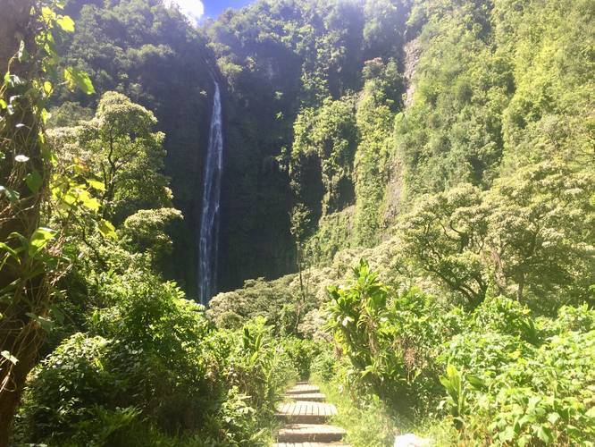
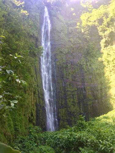
The Pipiwai Trail at Haleakala National Park in Hana, Hawaii is a 4-mile out-and-back trail that leads through a bamboo forest and up to the 400-foot waterfall, Waimoku Falls.
This trail is by far the most popular hike on Maui, second behind the Waihee Ridge Trail, so show up early if you want to hike this trail with minimal traffic.
The trail begins next to the restrooms at the main parking lot and heads uphill after passing an interpretive site featuring a replica hut that the native Hawaiians used to live in. The trail then crosses the Hana Highway and continues uphill. While following the trail up toward the first lookout point, Makahiku Falls, there's really not much to see.
Once you reach Makahiku Falls, you'll get a nice view of the waterfall, but you cannot see the pool or stream below. Makahiku Falls is roughly 0.5-miles into the hike, so it's a decent quarter-way marker. Just before and after Makahiku Falls, you'll find mango trees with plenty of fallen mangos on the ground - generally rotting and fermenting, which doesn't smell great.
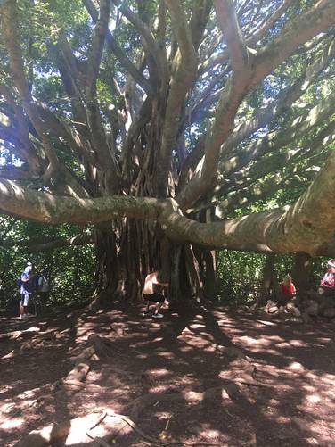
Continuing on from Makahiku Falls, you'll reach a massive banyan tree. The tree's branches reach far across the trail and drop trunks into the ground, somewhat scattered across the trail. Here you can make your way to the other side of the tree - take pictures, but make sure someone's in the picture to show the true size of the tree.
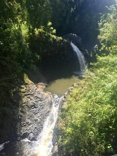
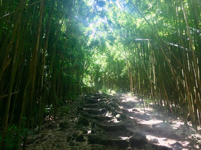
Not far after the banyan tree, you'll cross two bridges featuring two waterfalls, about 20-feet tall. This is also where the bamboo forest begins. The bamboo forest is extremely impressive - it features an unlimited amount of bamboo reaching about 30 to 40 feet in the air, if not higher. The shoots are about 4-inches in diameter or more, so it's truly a well-established bamboo forest. As you hike through the bamboo forest, you'll hear the bamboo swaying from the wind and knocking into each other - it's a really interesting an unique sound. As a side note, on the hike, we passed hikers listening to music without headphones - don't be those people.. try to enjoy the nature around you and the sights and sounds you'll experience nowhere else.
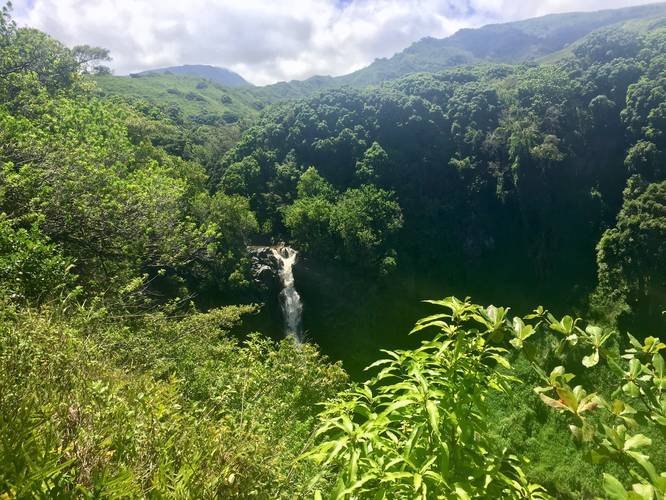
After the bamboo forest ends, you're not far from Waimoku Falls. You'll hike along another boardwalk toward a creek crossing - here you can get amazing views of Waimoku Falls, but the best views are yet to come. Further up the trail you'll need to cross at least one creek to reach the best views of the falls. Do not cross the creek if the water is high and rushing. Also pay attention to the rain and weather as flash floods are common in this stream.
After crossing the creek, you'll reach a brown sign stating not to continue beyond the sign. This is more of a suggestion and less of a hard and fast rule since 95% of the hikers who make it up to the waterfall ignore the sign and continue onward. Just beyond the sign is the best view of the waterfall - without crossing the creek again and getting to the pool. Here you can take in the waterfall without risking another creek crossing and this is where we decided to end our hike.
You can continue, at your own risk, across the Pipiwai Stream and head over to the pool below the waterfall and swim. Since this is such a popular trail to hike and swim at, you'll see plenty of hikers crossing the creek to go swimming.
Heading back down to parking is not difficult, but can be slower if the ground is wet since it can be very slippery.
Points of Interest: Bamboo forest, Waimoku Falls (400-feet tall), Makahiku Falls, a large banyan tree, additional smaller (20-foot) waterfalls, and mango trees.
Parking: Parking can be found at the large main lot after passing the pay station at the park. There's an additional overflow lot which is often used since this trail gets very busy.
What to bring: Plan to bring at least 1-liter of water per person on this hike. You can fill up water bottles at the trailhead next to the restrooms. Plan to bring bug spray since the mosquitoes can be annoying. Also bring proper footwear since the uphill climb is not easy when the ground is wet.
Facilities: There are restrooms and a potable water station at the trailhead by the main parking lot.
Flooding & Dangers: This trail lies within an area of Maui that generally gets a decent amount of rainfall. Heavy rains upstream can trigger flash floods that sweep down this creek, so watch the weather and do not hike this trail if there are heavy rains in the weather forecast. Do not attempt to cross the creek if it's running high and the flow is strong to reduce risk of injury, drowning, or both.
Fees: There's a $25 entry fee for Haleakala National Park. The ticket you receive is good for 7-days (make sure to check the Haleakala National Park's site), but I highly encourage you to purchase the $50 annual pass if you plan to visit more national parks within the next 365 days.
Pets: Pets are not permitted on any trails.
Respecting the Land
Hawaiian land is considered sacred to native Hawaiians and many locals, so please stay on-trail, take nothing but photos, and leave nothing but footprints. Respect the locals - don't stay for long and have a backup hike planned in case the parking lot is full.
This trail is by far the most popular hike on Maui, second behind the Waihee Ridge Trail, so show up early if you want to hike this trail with minimal traffic.
The trail begins next to the restrooms at the main parking lot and heads uphill after passing an interpretive site featuring a replica hut that the native Hawaiians used to live in. The trail then crosses the Hana Highway and continues uphill. While following the trail up toward the first lookout point, Makahiku Falls, there's really not much to see.
Once you reach Makahiku Falls, you'll get a nice view of the waterfall, but you cannot see the pool or stream below. Makahiku Falls is roughly 0.5-miles into the hike, so it's a decent quarter-way marker. Just before and after Makahiku Falls, you'll find mango trees with plenty of fallen mangos on the ground - generally rotting and fermenting, which doesn't smell great.
Continuing on from Makahiku Falls, you'll reach a massive banyan tree. The tree's branches reach far across the trail and drop trunks into the ground, somewhat scattered across the trail. Here you can make your way to the other side of the tree - take pictures, but make sure someone's in the picture to show the true size of the tree.
Not far after the banyan tree, you'll cross two bridges featuring two waterfalls, about 20-feet tall. This is also where the bamboo forest begins. The bamboo forest is extremely impressive - it features an unlimited amount of bamboo reaching about 30 to 40 feet in the air, if not higher. The shoots are about 4-inches in diameter or more, so it's truly a well-established bamboo forest. As you hike through the bamboo forest, you'll hear the bamboo swaying from the wind and knocking into each other - it's a really interesting an unique sound. As a side note, on the hike, we passed hikers listening to music without headphones - don't be those people.. try to enjoy the nature around you and the sights and sounds you'll experience nowhere else.
After the bamboo forest ends, you're not far from Waimoku Falls. You'll hike along another boardwalk toward a creek crossing - here you can get amazing views of Waimoku Falls, but the best views are yet to come. Further up the trail you'll need to cross at least one creek to reach the best views of the falls. Do not cross the creek if the water is high and rushing. Also pay attention to the rain and weather as flash floods are common in this stream.
After crossing the creek, you'll reach a brown sign stating not to continue beyond the sign. This is more of a suggestion and less of a hard and fast rule since 95% of the hikers who make it up to the waterfall ignore the sign and continue onward. Just beyond the sign is the best view of the waterfall - without crossing the creek again and getting to the pool. Here you can take in the waterfall without risking another creek crossing and this is where we decided to end our hike.
You can continue, at your own risk, across the Pipiwai Stream and head over to the pool below the waterfall and swim. Since this is such a popular trail to hike and swim at, you'll see plenty of hikers crossing the creek to go swimming.
Heading back down to parking is not difficult, but can be slower if the ground is wet since it can be very slippery.
Points of Interest: Bamboo forest, Waimoku Falls (400-feet tall), Makahiku Falls, a large banyan tree, additional smaller (20-foot) waterfalls, and mango trees.
Parking: Parking can be found at the large main lot after passing the pay station at the park. There's an additional overflow lot which is often used since this trail gets very busy.
What to bring: Plan to bring at least 1-liter of water per person on this hike. You can fill up water bottles at the trailhead next to the restrooms. Plan to bring bug spray since the mosquitoes can be annoying. Also bring proper footwear since the uphill climb is not easy when the ground is wet.
Facilities: There are restrooms and a potable water station at the trailhead by the main parking lot.
Flooding & Dangers: This trail lies within an area of Maui that generally gets a decent amount of rainfall. Heavy rains upstream can trigger flash floods that sweep down this creek, so watch the weather and do not hike this trail if there are heavy rains in the weather forecast. Do not attempt to cross the creek if it's running high and the flow is strong to reduce risk of injury, drowning, or both.
Fees: There's a $25 entry fee for Haleakala National Park. The ticket you receive is good for 7-days (make sure to check the Haleakala National Park's site), but I highly encourage you to purchase the $50 annual pass if you plan to visit more national parks within the next 365 days.
Pets: Pets are not permitted on any trails.
Respecting the Land
Hawaiian land is considered sacred to native Hawaiians and many locals, so please stay on-trail, take nothing but photos, and leave nothing but footprints. Respect the locals - don't stay for long and have a backup hike planned in case the parking lot is full.