Loading...

Distance:
0 Miles / 0 km
Type:
Out-and-Back
Difficulty:
Easy
Time to Hike:
~5 minutes
Features:
Surface Type:
Dirt
Park:
Grand Staircase-Escalante National Monument
Town:
Henrieville, Utah
Directions:
37.621237, -111.870541
Added:
September 26, 2023
Updated:
October 03, 2023
Loading...
Loading...
10 '

Total Change
11 '

Ascent
11 '

Descent

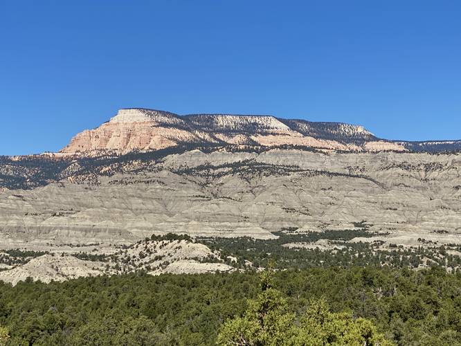
The Pink Cliffs View and Campsite at Grand Staircase-Escalante National Monument near Henrieville, Utah is an easy out-and-back walk that leads to a roadside campsite along with a view of the Pink Cliffs.

This is not a hike but rather a short walk located north of UT-12 east of Henrieville to a small roadside campsite. From the campsite, visitors will get a view of the Pink Cliffs in the distance.

Parking
Visitors will find parking at the coordinates provided - the turnout is large enough to fit a few vehicles at most.

Pets
Dogs are allowed if leashed and must be cleaned up after.

Camping
Backcountry / primitive / dispersed camping is permitted at the Grand Staircase-Escalante National Monument. Please be respectful and pack-out everything you packed-in if you plan on camping.

Explore 28 trails near Henrieville, UT
  1. Parking

    37.621237, -111.870541
  2. Main Trailhead

    37.621304, -111.870606
  3. View of the Pink Cliffs within Grand Staircase-Escalante National Monument

    37.621569, -111.870772
    View of the Pink Cliffs within Grand Staircase-Escalante National Monument
No community routes found. To add your own hike as a Community Route for this Trail guide, leave a Trip Report with an attached GPX file.

Hazards

Snakes

Seasons

All

Photo Albums

2 Trip Reports

No Star-Ratings
Write-up by:
Admin user profile picture
0 miles / 0 km
Trail added
September 26, 2023
Hiked on
September 26, 2023
Updated on
October 03, 2023
0 miles / 0 km
September 26, 2023
Hiking

Weather Forecast

In Henrieville, UT

Explore Hiking Trails

New Hikes

Eternal Flame Falls via Eternal Flame Trail
1.2 Miles
1.9 km
Moderate
Out-and-Back
Weston Lake Loop
3.2 Miles
5.1 km
Easy
Loop
Raven Rocks via Appalachian Trail
5.1 Miles
8.2 km
Strenuous
Out-and-Back
Cold Run Waterfalls & Vista Loop
3.1 Miles
5 km
Moderate
Loop

Before you leave...

MyHikes is an indie web platform aimed to make exploring public trails easier for everyone. The site has no investors and is owned and operated by one person, Dave Miller (Founder & Admin). As the Founder, main contributor, and doer-of-all-things for MyHikes, I share my trips with over-detailed write-ups for fun on a volunteer basis and I believe that public trail information should be available to everyone.

It takes a lot of time 🕦, money 💰, and effort (including espresso shots ☕) to run MyHikes, including hiking , mapping , writing , and publishing new trails with high-quality content... along with building new features, moderating, site maintainance, and app development for iOS and Android . I simply ask that if you find MyHikes' trail guides helpful to please consider becoming a Supporter to help keep the site, iOS, and Android apps available to everyone.

Supporters unlock website and in-app perks with a one-time payment of $25 (you renew) 😎👍. Or you can simply make a Donation of your choice without a MyHikes user account. Otherwise, telling your friends about MyHikes is the next-best thing - both quick and free 🎉

Thanks for visiting MyHikes and have a great hike!️

Admin user profile picture

Dave Miller
MyHikes Founder & Admin