Loading...

🔥 End of Summer sale! 50% off on Supporter Accounts — now through September 1st. Learn More.

Piney Branch Hike

Directions
Map
Pictures
Send to App
Distance:
9.0 Miles / 14.5 km
Type:
Loop
Difficulty:
Moderate
Time to Hike:
4 hours, ~30 minutes
Features:
Surface Type:
Dirt
Park:
Shenandoah National Park
Town:
Washington, Virginia
Directions:
38.730236, -78.255952
Added:
March 18, 2025
Updated:
April 05, 2025
Guide by:
Copy Trail Link Hiking this trail? Send a friend or family member a link to this trail guide for your own safety. Hike at your own risk (disclaimer)
Loading...
Loading...
1,510'

Total Change
2,021'

Ascent
2,017'

Descent

Download the Trail Route for Offline Use

Supporters get exclusive access to download trail routes to the MyHikes app for offline use. Stay prepared on your adventure, even without an internet connection! Become a Supporter today to unlock this feature and hike with confidence.

Send to App

Piney Branch Hike

While this hike may not have the sweeping vistas you often find on other Shenandoah National Park hikes, it features great trails that wind through scenic valleys. For a more scenic route also consider doing the hike counterclockwise and taking the Little Devils Stairs Trail instead of the Keyser Run Fire Rd.


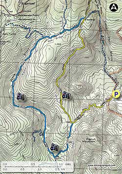
  • Mile 0.0 – Start uphill on the Keyser Run Fire road which will take you into the Shenandoah National Park, and ascending for the first 1.2 miles to the junction of the Hull School Trail and the Bolen Cemetery.
  • Mile 1.2 - Veer left on the Hull School Trail for 0.7 miles downhill to the junction of the Piney Branch Trail.
  • Mile 1.9 - Turn right on the Piney Branch Trail and in 200 yards cross Piney River. At 0.4 miles on the Piney Branch Trail the Piney Ridge Trail will come in on your left. Continue straight for another 1.0 miles where you will cross back over Piney River.
  • Mile 3.3 - Ascend the Piney Branch Trail for another 1.3 miles on the right side of the valley until coming to the junction of the Poll Bridge Link Trail on the right. The Piney Branch Trail turns left.
  • Mile 4.6 - Turn right on the Pole Bridge Link Trail and pass the Sugarloaf Trail on the left in 0.4 miles. In another 0.5 miles arrive at the junction of the Keyser Run Fire road.
  • Mile 5.5 - Turn right on the yellow blazed Keyser Run Fire road and begin your descent for the 2.5 miles back to the intersection of the Hull School Trail and the Bolen Cemetery.
  • Mile 6.8 - Turn left down the Keyser Run Fire road for the final 1.2 miles back to the parking lot.
  • Mile 9.0 - Arrive back at the Little Devils Stairs parking area
Explore 93 trails near Washington, VA
  1. Parking

    38.730236, -78.255952
  2. Main Trailhead

    38.730519, -78.258233
No community routes found. To add your own hike as a Community Route for this Trail guide, leave a Trip Report with an attached GPX file.

Hazards

Ticks - Lyme Disease More Info (CDC)
Snakes
Poison Ivy/Oak

Seasons

All

Photo Albums

+ Add Photo Album

Upload your photos from the trail to help others know what to expect.

Trip Reports (Reviews)

Rated 4.0 out of 5 based on 17 ratings.
By: Tom and Katie
9.0 miles / 14.5 km
August 27, 2019
Note error on parking directions: Keyser Run Road is VA 614, not VA 670. From HikingUpward: The road number has been updated. Thank you.
Legacy Review
By: Nate
9.0 miles / 14.5 km
August 03, 2019
We added Little Devil Stairs to end of our hike to make this about 13.2 miles (about 2 miles of this was due to backtracking). It took us about 5:15 hrs with :45 minutes for lunch and a quick swim. Our elevation change was about 1700ft up then down. We started up keyser road, stopped at the Bolan cemetery. We then went down Hull School Trail and unfortunately, we thought we had gone too far and missed the trail for Piney Branch trail so we backtracked to the cemetery to start from scratch. Headed back down only to find out we were about .2 miles from the intersection with Piney Branch Trail. This trail was lightly trafficked and we fought our way through some spiderwebs that were strung up by their owners hoping to catch an insect meal. I've dealt with much much worse spider infestations but it still annoying. On the righthand side, about 5.5 miles in (or probably 3.5/4.0 miles in had we not backtracked) there was a cascade of small falls and swimming holes. We stopped here, cooled off from the 90 degree heat, and ate lunch. This was our favorite from the hike. Following the trail up river, we saw several large piles of bear scat but not bears. We finished by taking LDS down. I had never done this before but my lord was it tough - and this was with very low water levels. My knees are barking a bit a day later. Very quiet hike. Only saw a few people on Keyser, a young couple posted up on a nice campsite on Piney Branch, and then a small group heading up LDS. If this hike had any views built into it at all, it would be a top 3 hike for me. Great nonetheless.
Legacy Review
By: David
9.0 miles / 14.5 km
September 02, 2018
Went for a Sunday day hike to escape the mugginess of D.C. Arrived around 10 am and started hiking, following the route Upward's laid out. Nice steady incline on the fire road got the blood flowing, and once entering into the single track area, the greenness of the hike took over. Hiking along the Piney Branch trail, we got to cross several beautiful streams and take in the view. The best spot was a cascading water fall, where we saw a beer and her two cubs! Even with a full sun out, the shade and stream kept us cool. Highly recommend this hike to anyone wanting a solid 9+ miles of day hiking. We even saw a rattle snake on the fire road heading back to the parking lot. Easy trails to follow, and no issues with markings.
Legacy Review

Weather Forecast

In Washington, VA

Explore Hiking Trails

You May Also Like

New York's Best Waterfalls - Whether you're planning a day hike, roadside stop, or a leisurely short walk, this guide provides hikers, travelers, and locals alike with 63 different locations to over 100 scenic waterfalls to help plan your next adventure!
Explore

New York's Best Waterfalls

Whether you're planning a day hike, roadside stop, or a leisurely short walk, this guide provides hikers, travelers, and locals alike with 63 different locations to over 100 scenic waterfalls to help plan your next adventure!

Read
25 Best Day Hikes in North Carolina - Discover the top 25 best day hikes in North Carolina, from breathtaking waterfalls to mountain peaks. Explore hidden gems, scenic views, and trails suitable for all skill levels, perfect for your next outdoor adventure.
Explore

25 Best Day Hikes in North Carolina

Discover the top 25 best day hikes in North Carolina, from breathtaking waterfalls to mountain peaks. Explore hidden gems, scenic views, and trails suitable for all skill levels, perfect for your next outdoor adventure.

Read

Before you boogie...

Find our trail guides useful? Consider becoming a Supporter to unlock perks!

MyHikes is an indie platform that makes exploring public trails easier for everyone. The platform has no investors, no ads, and is owned and operated by one person, Dave Miller. Dave has personally mapped and written over 1,800 trail guides on MyHikes for the public to explore. MyHikes has helped millions outdoor enthusiasts plan their next adventure.

But it takes a lot of time 🕦, money 💰, work, and espresso shots ☕ to run MyHikes, including hiking , mapping , writing , and publishing new trails with high-quality (accurate) information... along with software engineering (coding) the platform like building new features, website and mobile app development (iOS and Android), site maintainance . and much much more.

Supporters unlock website and mobile app perks with an annual one-time payment of $25 (you renew) 😎👍. Or you can simply make a Donation of your choice. Otherwise, you can support us by telling your friends about MyHikes - both quick and free 🎉

Admin user profile picture

Dave Miller
MyHikes Founder