The Pine Mountain Ski Trail at Susquehannock State Forest near Cross Fork, Pennsylvania is an easy 2-mile loop trail that features a nearby vista point and a nice relaxing hike through the woods.
The trail follows a dirt/grass path that leads along what seems like a service road and a narrower footpath following red blazes. Hikers can choose to hike the longer 2-mile loop or use a bisecting trail to reduce the length to about 1-mile.
Hikers or cross-country skiers will find the trail begins at a trailhead sign for the Lost Camp Trail adjacent to the parking lot. The trail crosses a natural gas pipeline before heading into the woods where there's a yellow and black gate to keep motorized vehicles out.
Just beyond the gate is where the loop trail starts - this recording stays left at the fork, but hikers will find a section of the trail that runs parallel to the main trail for about 100-feet before veering off -- this is the right-hand turn for the loop Pine Mountain Ski Trail loop.
Regardless of which direction you hike, the trail will follow red blazes. There is one main bisecting trail, not depicted in this GPS track, that connects both sides of the loop so that hikers can choose a shorter or longer hike. If you choose to pass beyond the bisecting trail, you will continue hiking to complete the loop for about 1.8-miles total.
At the western side of the loop, the trail meets up at a sharp angle near some conifer trees with the continuation for the loop. The Lost Camp Trail continues west, but following the loop from this part of the trail is easy.
Trail name(s):
This trail is also known as the Pine Mountain Trail and the Pine Mountain Cross-Country Ski Trail on the Susquehannock State Forest's website (http://www.docs.dcnr.pa.gov/cs/groups/public/documents/document/dcnr_20028038.pdf). Also note that this loop trail technically follows a portion of the Lost Camp Trail as well. There are no actual trailhead signs that depict the Pine Mountain Ski Trail in any way. The only markers are red blaze markers on the trees.
Parking
Hikers can find a large parking turnout at the coordinates provided.
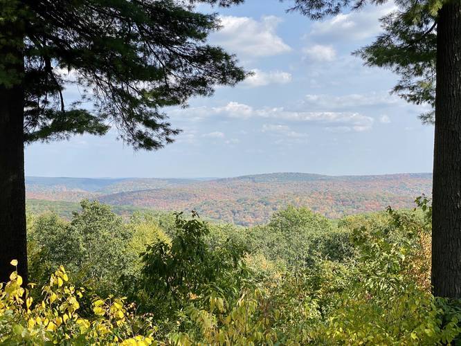
Vista Point - Pine Hill Summit Vista
Next to the parking lot, but not directly on the trail, is a nice vista point located at the summit of Pine Hill in the Allegheny Mountains.
Pets
Dogs are allowed if leashed.
Cross Country Skiing
As stated in the trail name, this trail is built for cross-country skiing.
Mountain Summit
While this trail is not located directly on Pine Hill Summit, the vista point is located nearby.
Camping and Backpacking
This trail does not have any dedicated campsites for primitive/backcountry/dispersed camping; however, the state forest's rules do not state against camping off-trail here.
The trail follows a dirt/grass path that leads along what seems like a service road and a narrower footpath following red blazes. Hikers can choose to hike the longer 2-mile loop or use a bisecting trail to reduce the length to about 1-mile.
Hikers or cross-country skiers will find the trail begins at a trailhead sign for the Lost Camp Trail adjacent to the parking lot. The trail crosses a natural gas pipeline before heading into the woods where there's a yellow and black gate to keep motorized vehicles out.
Just beyond the gate is where the loop trail starts - this recording stays left at the fork, but hikers will find a section of the trail that runs parallel to the main trail for about 100-feet before veering off -- this is the right-hand turn for the loop Pine Mountain Ski Trail loop.
Regardless of which direction you hike, the trail will follow red blazes. There is one main bisecting trail, not depicted in this GPS track, that connects both sides of the loop so that hikers can choose a shorter or longer hike. If you choose to pass beyond the bisecting trail, you will continue hiking to complete the loop for about 1.8-miles total.
At the western side of the loop, the trail meets up at a sharp angle near some conifer trees with the continuation for the loop. The Lost Camp Trail continues west, but following the loop from this part of the trail is easy.
Trail name(s):
This trail is also known as the Pine Mountain Trail and the Pine Mountain Cross-Country Ski Trail on the Susquehannock State Forest's website (http://www.docs.dcnr.pa.gov/cs/groups/public/documents/document/dcnr_20028038.pdf). Also note that this loop trail technically follows a portion of the Lost Camp Trail as well. There are no actual trailhead signs that depict the Pine Mountain Ski Trail in any way. The only markers are red blaze markers on the trees.
Parking
Hikers can find a large parking turnout at the coordinates provided.
Vista Point - Pine Hill Summit Vista
Next to the parking lot, but not directly on the trail, is a nice vista point located at the summit of Pine Hill in the Allegheny Mountains.
Pets
Dogs are allowed if leashed.
Cross Country Skiing
As stated in the trail name, this trail is built for cross-country skiing.
Mountain Summit
While this trail is not located directly on Pine Hill Summit, the vista point is located nearby.
Camping and Backpacking
This trail does not have any dedicated campsites for primitive/backcountry/dispersed camping; however, the state forest's rules do not state against camping off-trail here.