The Pine Loop at Personius Woods (Tanglewood Nature Center) in Big Flats, New York is an easy 0.5-mile loop hike that features a pine forest and small views of the neighboring hills.
Trails
This hike follows one named trail: Pine Loop (yellow blazes).
How to get to the Trailhead
Note that in order to get to this trail's trailhead, hikers must first take the Cottontail Trail (red blazes) to reach it -- you can hop on the Hornbeam Trail (orange blazes) right at the parking lot, which connects to the Cottontail Trail. Keep an eye out for yellow blazes and tall posts with small signs that read "Pine Loop" to locate the trailhead.
Hike Description
Once on the Pine Loop, hikers have a choice which direction to hike, but first they must hike in along a short spur trail -- the Pine Loop has two short spur trails that connect to the Cottontail Trail. Due to these spur trails, in addition to other bisecting trails, this loop is really confusing. Also note that this GPS track and write-up follows the Pine Loop in a clockwise direction.
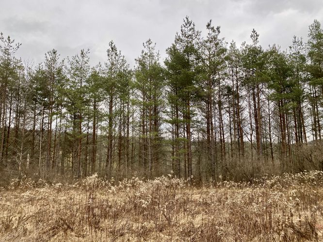
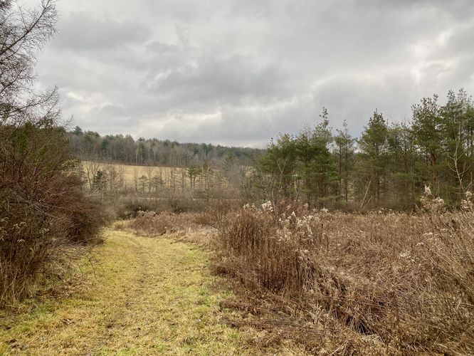
After hiking in on the spur trail, hikers will take a slight-left turn to continue hiking straight. The trail, during wet months, is generally very muddy in most sections of the trail -- here is no exception. The trail will run flat along a steep hillside, passing water drains, before hikers reach another "Pine Loop" trail sign pointing westward, around mile 0.1. Follow the trail as it begins its loop -- the trail will head back uphill toward a pine tree plantation. Eventually the trail loops northward and leads hikers into an open field with pine trees that line the eastern slopes, noted around mile 0.15. Here, the trail gets muddier again as the water doesn't have many places to drain, so watch your step. Follow the trail as it leads straight through the open field until you reach a final right-hand curve where you'll find a small view of the neighboring hills to the East. Hike down this wide path within the open field to reach the pine forest once again. Here, at mile 0.3, the yellow blazes are confusing -- there's a trail junction with several routes. Take a right-hand turn to hike the wide path that leads between the pines. I attempted to connect the 2nd spur trail, which most hikers can bypass; however, the yellow blazes take a left-hand turn to follow an overgrown yellow-blazed path that leads through a more narrow sections of pine trees. Not long after, at mile 0.45, hikers will reach the original spur trail that you hiked in on. Complete the loop at mile 0.5 by hiking out.
Parking
Hikers will find a small parking lot at the coordinates provided, located on the west side of West Hill Road in Elmira.
Pets
Dogs are allowed only if leashed and must be cleaned up after.
Warning
Muddy trail: This trail is pretty muddy during wet months and potentially muddy year-round.
Trails
This hike follows one named trail: Pine Loop (yellow blazes).
How to get to the Trailhead
Note that in order to get to this trail's trailhead, hikers must first take the Cottontail Trail (red blazes) to reach it -- you can hop on the Hornbeam Trail (orange blazes) right at the parking lot, which connects to the Cottontail Trail. Keep an eye out for yellow blazes and tall posts with small signs that read "Pine Loop" to locate the trailhead.
Hike Description
Once on the Pine Loop, hikers have a choice which direction to hike, but first they must hike in along a short spur trail -- the Pine Loop has two short spur trails that connect to the Cottontail Trail. Due to these spur trails, in addition to other bisecting trails, this loop is really confusing. Also note that this GPS track and write-up follows the Pine Loop in a clockwise direction.
After hiking in on the spur trail, hikers will take a slight-left turn to continue hiking straight. The trail, during wet months, is generally very muddy in most sections of the trail -- here is no exception. The trail will run flat along a steep hillside, passing water drains, before hikers reach another "Pine Loop" trail sign pointing westward, around mile 0.1. Follow the trail as it begins its loop -- the trail will head back uphill toward a pine tree plantation. Eventually the trail loops northward and leads hikers into an open field with pine trees that line the eastern slopes, noted around mile 0.15. Here, the trail gets muddier again as the water doesn't have many places to drain, so watch your step. Follow the trail as it leads straight through the open field until you reach a final right-hand curve where you'll find a small view of the neighboring hills to the East. Hike down this wide path within the open field to reach the pine forest once again. Here, at mile 0.3, the yellow blazes are confusing -- there's a trail junction with several routes. Take a right-hand turn to hike the wide path that leads between the pines. I attempted to connect the 2nd spur trail, which most hikers can bypass; however, the yellow blazes take a left-hand turn to follow an overgrown yellow-blazed path that leads through a more narrow sections of pine trees. Not long after, at mile 0.45, hikers will reach the original spur trail that you hiked in on. Complete the loop at mile 0.5 by hiking out.
Parking
Hikers will find a small parking lot at the coordinates provided, located on the west side of West Hill Road in Elmira.
Pets
Dogs are allowed only if leashed and must be cleaned up after.
Warning
Muddy trail: This trail is pretty muddy during wet months and potentially muddy year-round.