The Pine Cliff Trail & Waterfalls at Tiadaghton State Forest near Cammal, Pennsylvania is a moderate 0.6-mile out-and-back hike that follows the Pine Creek Trail and a section of the eroding Pine Cliff Trail to view a couple 3-foot waterfalls.
Looking for the Pine Cliff Vista?
Skip this guide and instead check out the Pine Cliff Vista via Bob Webber Trail guide. The creek-side portion of the Pine Cliff Trail has been washed away, as of January 2023, and thus is dangerous for most hikers to follow its entire length (more notes in this guide).
Hike Description
This hike was an attempt to follow the entire Pine Cliff Trail, but upon our winter hike on January 1, 2023, we found the trail is starting to erode pretty badly into the creek. Please note that we stopped a few-hundred feet before the trail hits a switchback as it climbs the mountainside due to the lack of trail to follow. If you choose to follow this trail, trekking poles are recommended along with proper footwear and experience traversing eroded creekside trails.
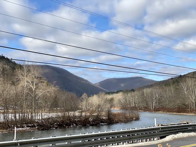
If choosing to follow this path, hikers can find small parking turnouts along PA-414 near the telephone poles across the road from the Pine Creek Trail. Note that parking here can be tricky during warm months when there's a lot more traffic on this road - park at your own risk.
This track follows the Pine Creek Trail north for 0.2-miles before hitting Wolf Run.
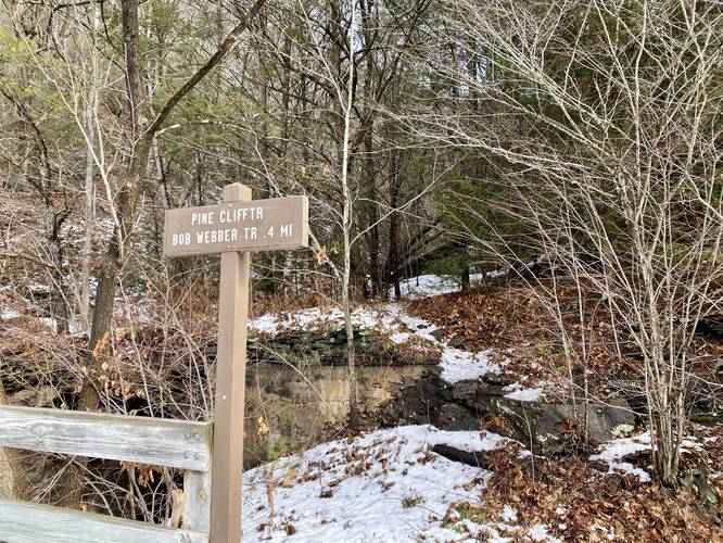
Pine Cliff Trail Junction (Right-Hand Turn) - Mile 0.2
At mile 0.2, hikers will reach a creek named Wolf Run and a trail named the Pine Cliff Trail. Take this right-hand turn to head into the slowly-eroding and skinny, Pine Cliff Trail.
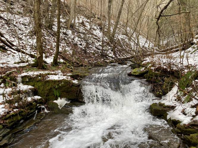
Once on the Pine Cliff Trail, the hiking gets more difficult as the terrain becomes loosely bound to the creek banks. Hikers will have to traverse up and down some small footholds in the bank's slopes to make their way up the trail - hence the "moderate" difficulty. Along the way are small waterfalls in Wolf Run - known as Lower Wolf Run Falls. They're not much taller than 3-feet total.
Lower Wolf Run Falls - Mile 0.25
Around mile 0.25 into the hike (0.03 miles into the Pine Cliff Trail), hikers will reach a small 3-foot waterfall, Lower Wolf Run Falls. This small cascade is the main attraction for folks who do not wish to risk hiking much further up the eroded Pine Cliff Trail.
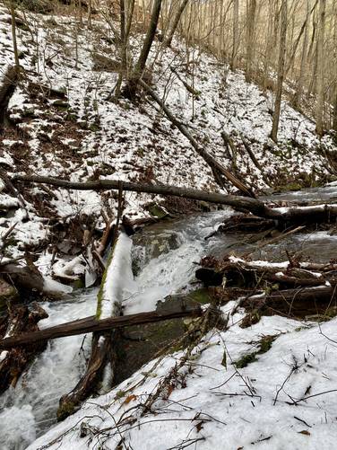
Small Waterfall - Mile 0.28
At mile 0.28, just upstream, lies another small 3-foot waterfall that cascades down Wolf Run between two larger rocks.
Rocky Outcropping / Eroded Trail - mile 0.3
Around mile 0.3 into the hike, or maybe 0.1-miles into the Pine Cliff Trail, is where the trail hits a rocky outcropping. Just beyond this outcropping is where the trail becomes so eroded that it's not safe to traverse any further with a group of hikers. We didn't have trekking poles, had a small dog with us, and the slippery icy and snowy trail didn't give us enough confidence to continue further. Additionally, a couple small weight test on the trail's soil proved that just one false move on the trail may lead the hiker to tumble into the icy creek, so we turned back here.
Parking
Hikers can find small parking turnouts along PA-414 near the telephone poles across the road from the Pine Creek Trail. Note that parking here can be tricky during warm months when there's a lot more traffic on this road and may not be recommended during heavier traffic seasons - park at your own risk.
Pets
Dogs are allowed if leashed and their waste should be carried out by the hiker.
Biking
Biking is permitted along the Pine Creek Trail.
Looking for the Pine Cliff Vista?
Skip this guide and instead check out the Pine Cliff Vista via Bob Webber Trail guide. The creek-side portion of the Pine Cliff Trail has been washed away, as of January 2023, and thus is dangerous for most hikers to follow its entire length (more notes in this guide).
Hike Description
This hike was an attempt to follow the entire Pine Cliff Trail, but upon our winter hike on January 1, 2023, we found the trail is starting to erode pretty badly into the creek. Please note that we stopped a few-hundred feet before the trail hits a switchback as it climbs the mountainside due to the lack of trail to follow. If you choose to follow this trail, trekking poles are recommended along with proper footwear and experience traversing eroded creekside trails.
If choosing to follow this path, hikers can find small parking turnouts along PA-414 near the telephone poles across the road from the Pine Creek Trail. Note that parking here can be tricky during warm months when there's a lot more traffic on this road - park at your own risk.
This track follows the Pine Creek Trail north for 0.2-miles before hitting Wolf Run.
Pine Cliff Trail Junction (Right-Hand Turn) - Mile 0.2
At mile 0.2, hikers will reach a creek named Wolf Run and a trail named the Pine Cliff Trail. Take this right-hand turn to head into the slowly-eroding and skinny, Pine Cliff Trail.
Once on the Pine Cliff Trail, the hiking gets more difficult as the terrain becomes loosely bound to the creek banks. Hikers will have to traverse up and down some small footholds in the bank's slopes to make their way up the trail - hence the "moderate" difficulty. Along the way are small waterfalls in Wolf Run - known as Lower Wolf Run Falls. They're not much taller than 3-feet total.
Lower Wolf Run Falls - Mile 0.25
Around mile 0.25 into the hike (0.03 miles into the Pine Cliff Trail), hikers will reach a small 3-foot waterfall, Lower Wolf Run Falls. This small cascade is the main attraction for folks who do not wish to risk hiking much further up the eroded Pine Cliff Trail.
Small Waterfall - Mile 0.28
At mile 0.28, just upstream, lies another small 3-foot waterfall that cascades down Wolf Run between two larger rocks.
Rocky Outcropping / Eroded Trail - mile 0.3
Around mile 0.3 into the hike, or maybe 0.1-miles into the Pine Cliff Trail, is where the trail hits a rocky outcropping. Just beyond this outcropping is where the trail becomes so eroded that it's not safe to traverse any further with a group of hikers. We didn't have trekking poles, had a small dog with us, and the slippery icy and snowy trail didn't give us enough confidence to continue further. Additionally, a couple small weight test on the trail's soil proved that just one false move on the trail may lead the hiker to tumble into the icy creek, so we turned back here.
Parking
Hikers can find small parking turnouts along PA-414 near the telephone poles across the road from the Pine Creek Trail. Note that parking here can be tricky during warm months when there's a lot more traffic on this road and may not be recommended during heavier traffic seasons - park at your own risk.
Pets
Dogs are allowed if leashed and their waste should be carried out by the hiker.
Biking
Biking is permitted along the Pine Creek Trail.