Loading...

🎉 Enjoy a Free 7-Day Supporter Trial and Unlock Exclusive Perks — No Credit Card Required. Learn more.

Photo-Birdseye Trails Loop

Directions
Map
Pictures
Send to App
Distance:
0.2 Miles / 0.3 km
Type:
Loop
Difficulty:
Moderate
Time to Hike:
~10 minutes
Features:
Surface Type:
Dirt
Park:
Dixie National Forest
Town:
Panguitch, Utah
Directions:
37.745453, -112.326879
Added:
September 25, 2023
Updated:
November 22, 2023
Copy Trail Link Hiking this trail? Send a friend or family member a link to this trail guide for your own safety. Hike at your own risk (disclaimer)
Loading...
Loading...
95'

Total Change
103'

Ascent
103'

Descent

Download the Trail Route for Offline Use

Supporters get exclusive access to download trail routes to the MyHikes app for offline use. Stay prepared on your adventure, even without an internet connection! Become a Supporter today to unlock this feature and hike with confidence.

Send to App

Photo-Birdseye Trails Loop

The Photo-Birdseye Trails Loop at Dixie National Forest near Panguitch, Utah is a moderate 0.2-mile loop hike that features natural rock formations similar to those found at Bryce Canyon National Park.

Hike Description
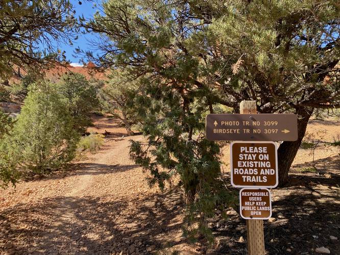
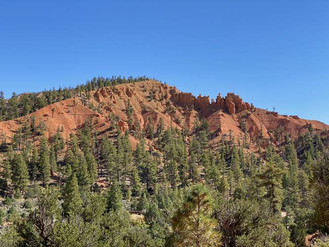
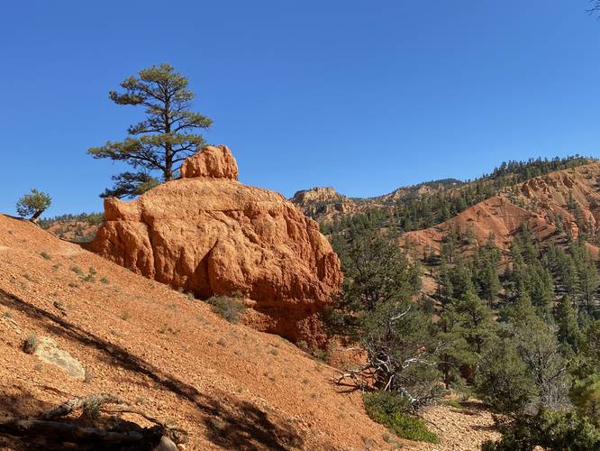
This short, but moderate hike, begins at the main trailhead for the Photo Trail / Birdseye Trail - both of which start right next to each other along UT-12. This hike heads in along the Photo Trail first and follows its steep ascent up to where it bends to the right to continue onward to the Birdseye Trail. Along the way, hikers will find towering rock formations -- these rock formations are smaller but are essentially the same type of formations that hikers will find in Bryce Canyon National Park; however, there's virtually no people along this loop.

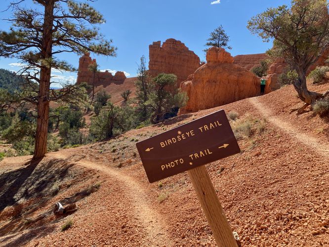
Hikers will take a right-hand turn along the Birdseye Trail around mile 0.1. Take the steep Birdseye Trail downhill and back to parking -- remember to enjoy the cool rock formations (and seclusion) on your hike down.

Parking
Hikers will find two large parking turnouts on either side of UT-12. Each parking turnout is large enough to fit about 8 cars as of September 2023.

Pets
Dogs are allowed if leashed and must be cleaned up after.

Warnings
Rattlesnakes: This area is home to rattlesnakes which might be out sunning during the midday sun. If encountered, give them plenty of space.

Rockfall / falling rock: This hike passes through areas of natural rock formations and cliff outcroppings - some of which have rockfall activity at random times. Hike at your own risk.
Explore 24 trails near Panguitch, UT
  1. Parking

    37.745453, -112.326879
  2. Main Trailhead

    37.745614, -112.32683
  3. Trailhead junction at Photo Trail / Birdseye Trail

    37.745719, -112.326911
    Trailhead junction at Photo Trail / Birdseye Trail
  4. View from the Birdseye Trail

    37.746411, -112.327408
    View from the Birdseye Trail
  5. Bulbus rock formation along the Birdseye Trail at Dixie National Forest

    37.74675, -112.327247
    Bulbus rock formation along the Birdseye Trail at Dixie National Forest
  6. Birdseye Trail trailhead

    37.7467, -112.326736
     Birdseye Trail trailhead
No community routes found. To add your own hike as a Community Route for this Trail guide, leave a Trip Report with an attached GPX file.

Hazards

Snakes
Rockfalls / Ledges / or Scrambles

Seasons

All

Trip Reports

Trail Guide By:
Admin user profile picture
0.2 miles / 0.3 km
0.2 miles / 0.3 km
September 25, 2023
Short hike but secluded, plus rock features similar to Bryce Canyon with no crowds.
Hiking
Preview of the MyHikes mobile app interface

Track, Log, and Explore Hikes with the MyHikes App

Shop Landscape Prints
Shop our landscape prints from popular locations around Utah

Weather Forecast

In Panguitch, UT

Explore Hiking Trails

You May Also Like

Colorado's Million Dollar Highway - Plan a day's drive adventure along the iconic Million Dollar Highway in Colorado. Explore the best short trails, roadside stops, waterfalls, vistas, ghost towns, and hot springs within a ~6 hour road trip.
Explore

Colorado's Million Dollar Highway

Plan a day's drive adventure along the iconic Million Dollar Highway in Colorado. Explore the best short trails, roadside stops, waterfalls, vistas, ghost towns, and hot springs within a ~6 hour road trip.

Read
Glacier's Going-to-the-Sun Road - Discover the breathtaking beauty of Glacier National Park along the iconic Going-to-the-Sun Road. From stunning roadside stops to picturesque waterfalls and vistas, this engineering marvel offers endless opportunities for exploration.
Explore

Glacier's Going-to-the-Sun Road

Discover the breathtaking beauty of Glacier National Park along the iconic Going-to-the-Sun Road. From stunning roadside stops to picturesque waterfalls and vistas, this engineering marvel offers endless opportunities for exploration.

Read
New York's Best Waterfalls - Whether you're planning a day hike, roadside stop, or a leisurely short walk, this guide provides hikers, travelers, and locals alike with 63 different locations to over 100 scenic waterfalls to help plan your next adventure!
Explore

New York's Best Waterfalls

Whether you're planning a day hike, roadside stop, or a leisurely short walk, this guide provides hikers, travelers, and locals alike with 63 different locations to over 100 scenic waterfalls to help plan your next adventure!

Read

Before you boogie...

Find our trail guides useful? Consider becoming a Supporter to unlock perks!

MyHikes is an indie platform that makes exploring public trails easier for everyone. The platform has no investors, no ads, and is owned and operated by one person, Dave Miller. Dave has personally mapped and written over 1,800 trail guides on MyHikes for the public to explore. MyHikes has helped millions outdoor enthusiasts plan their next adventure.

But it takes a lot of time 🕦, money 💰, work, and espresso shots ☕ to run MyHikes, including hiking , mapping , writing , and publishing new trails with high-quality (accurate) information... along with software engineering (coding) the platform like building new features, website and mobile app development (iOS and Android), site maintainance . and much much more.

Supporters unlock website and mobile app perks with an annual one-time payment of $25 (you renew) 😎👍. Or you can simply make a Donation of your choice. Otherwise, you can support us by telling your friends about MyHikes - both quick and free 🎉

Admin user profile picture

Dave Miller
MyHikes Founder