The Perimeter Trail at Fisher Hill Town Forest in Francestown, New Hampshire is an easy 1.3-mile loop hike that features a peaceful forest setting, large boulders, and mountain bike bridges.
Trail name: Perimeter Trail
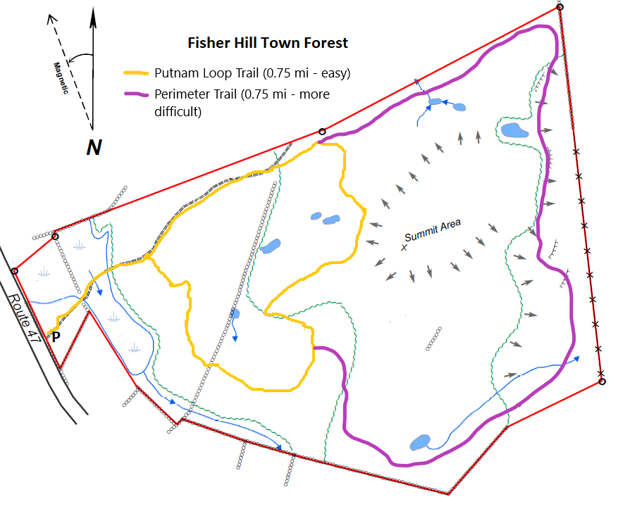
Location: Rte. 47, Fisher Hill Town Forest, Francestown NH
Allowed activities: Hiking, Biking, Nature Study, Show Shoe, Hunting
Forbidden activities: No ATV’s
Hours: No posted hours
Fees and Parking: There is no fee to park or use the trails. Space is limited. At best, the lot can hold up to 6 small cars if each visitor parks considerately. Parking alongside Route 47 is not recommended as Route 47 can be treacherous and the entrance to parking area does not have good signage and it is just past a corner on the road where drivers tend to go too fast.
Pets: As is the case with all Town Forest Lands in Francestown, Dogs must remain on a leash at all times - this is to protect wildlife, other trail users, and sensitive natural environments (exception for hunting dogs in active hunting or training during hunting season).
Accessibility: The trail is not wheelchair accessible
Sanitation: There is no restroom or trash bin at the trailhead or on the trail. Please carry out what you carry in.
Length and Trail information: This hike is an easy hike, roughly 1.1 miles in length as it was hiked. The trail is a recent addition off of the existing Putnam Loop Trail and was done as a loop, starting and ending on the Putnam Loop Trail. There is no kiosk or information board at the parking area. Plowing is not guaranteed in winter. To access the Perimeter trail, hikers will need to first start on the Putnam Loop Trail. The Putnam Loop Trail begins right off of the parking area just beyond a double wooden gate. There is a sign on the gate prohibiting ATV’s from using the trail and there is also a sign posted on a tree adjacent to the trail that lets visitors know that the area is multi use and hunters could be present. There are no trail blaze markers on The Putnam Loop trail, only a couple of trail name signs. The Perimeter Trail has some red blazes; however, these blazes are most likely marking the boundary and not the trail itself. The trail is easy to follow as long as there is not snow on the ground. The trail lives up to its name and comes very close to the perimeter of the forest. Hikers will be able to see old stone walls that were no doubt once used as boundaries. Even though there are no official markers or blazes to mark the trail, the trail had an evident path as well as orange plastic tape sporadically tied to tree branches. If in doubt, stop and look for evidence of activity from humans, i.e.: a cairn, cut tree or marker. Hikers may download and print a map of the trail by following the link below:
https://www.francestownnh.org/sites/g/files/vyhlif581/f/uploads/fh-trail-map_v1_0.png
The layout of the trail is interesting and offers hikers an opportunity to appreciate the solitude of this bucolic spot. Along the trail several sturdy wooden bridges and ramps have been strategically installed to enhance the trail for those who enjoy mountain biking. The trail substrate is often uneven and has numerous areas where roots or rocks protrude, and care should be used especially when hiking along the edge of the trail as it skirts a ravine. The majority of the terrain is suitable for hikers of all skill levels as the hike is neither too steep nor too long.
Trail name: Perimeter Trail
Location: Rte. 47, Fisher Hill Town Forest, Francestown NH
Allowed activities: Hiking, Biking, Nature Study, Show Shoe, Hunting
Forbidden activities: No ATV’s
Hours: No posted hours
Fees and Parking: There is no fee to park or use the trails. Space is limited. At best, the lot can hold up to 6 small cars if each visitor parks considerately. Parking alongside Route 47 is not recommended as Route 47 can be treacherous and the entrance to parking area does not have good signage and it is just past a corner on the road where drivers tend to go too fast.
Pets: As is the case with all Town Forest Lands in Francestown, Dogs must remain on a leash at all times - this is to protect wildlife, other trail users, and sensitive natural environments (exception for hunting dogs in active hunting or training during hunting season).
Accessibility: The trail is not wheelchair accessible
Sanitation: There is no restroom or trash bin at the trailhead or on the trail. Please carry out what you carry in.
Length and Trail information: This hike is an easy hike, roughly 1.1 miles in length as it was hiked. The trail is a recent addition off of the existing Putnam Loop Trail and was done as a loop, starting and ending on the Putnam Loop Trail. There is no kiosk or information board at the parking area. Plowing is not guaranteed in winter. To access the Perimeter trail, hikers will need to first start on the Putnam Loop Trail. The Putnam Loop Trail begins right off of the parking area just beyond a double wooden gate. There is a sign on the gate prohibiting ATV’s from using the trail and there is also a sign posted on a tree adjacent to the trail that lets visitors know that the area is multi use and hunters could be present. There are no trail blaze markers on The Putnam Loop trail, only a couple of trail name signs. The Perimeter Trail has some red blazes; however, these blazes are most likely marking the boundary and not the trail itself. The trail is easy to follow as long as there is not snow on the ground. The trail lives up to its name and comes very close to the perimeter of the forest. Hikers will be able to see old stone walls that were no doubt once used as boundaries. Even though there are no official markers or blazes to mark the trail, the trail had an evident path as well as orange plastic tape sporadically tied to tree branches. If in doubt, stop and look for evidence of activity from humans, i.e.: a cairn, cut tree or marker. Hikers may download and print a map of the trail by following the link below:
https://www.francestownnh.org/sites/g/files/vyhlif581/f/uploads/fh-trail-map_v1_0.png
The layout of the trail is interesting and offers hikers an opportunity to appreciate the solitude of this bucolic spot. Along the trail several sturdy wooden bridges and ramps have been strategically installed to enhance the trail for those who enjoy mountain biking. The trail substrate is often uneven and has numerous areas where roots or rocks protrude, and care should be used especially when hiking along the edge of the trail as it skirts a ravine. The majority of the terrain is suitable for hikers of all skill levels as the hike is neither too steep nor too long.


