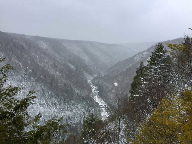
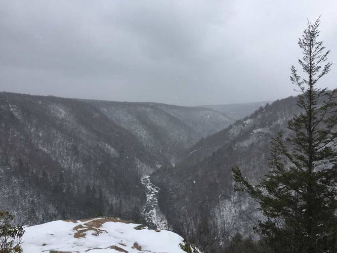
Pendleton Overlook
This is one of the best lookout points in the park is very popular during warmer months.
Know Before You Go
Interactive topographic map for Pendleton Overlook located in Davis, WV. Click the "View Map" button to load GPS coordinates and trail markers.
View map
Get directions
- Distance
- 0.2 mi
- Difficulty
- Easy
- Type
- Out-and-Back
- Est. Time
- 6 min
- Elev. Gain
- 12'
- Rating
- 0.0
- Added
- March 11, 2018
- Updated
- March 11, 2018
Weather Forecast
Don't let Google decide who you trust.


Loading...
<strong>Trail map and elevation chart not rendering in print mode?</strong> Simply scroll to the trail map section, then try printing again!
Total Change
18 ft.
5 m
5 m
Ascent
12 ft.
4 m
4 m
Descent
19 ft.
6 m
6 m
Loading...
Features
- Vista / Lookout Point
- Dogs
Points of interest
-
Parking
39.113132, -79.499097 -
Main Trailhead
39.113132, -79.499097 -
Vista from Pendleton Overlook
39.112397, -79.499672 -
Vista from Pendleton Overlook
39.11245, -79.500344
Safety information
For your own safety: plan ahead, let someone know where you'll be, and hike at your own risk.
Availability
All seasons
Surface type
Dirt
Trip Reports (Reviews)
Ready to help fellow hikers? Add a trip report to share your experience!
No community routes found. To add your own hike as a Community Route for this Trail guide, leave a Trip Report with an attached GPX file.


You may also like

Explore
25 Best Day Hikes in West Virginia
Discover 25 of the best day hikes in West Virginia, from scenic overlooks to wilderness trails—perfect for every level of hiker.

Explore
25 Best Day Hikes in Virginia
Explore the top hikes in Virginia, from iconic trails in Shenandoah National Park to hidden gems in the Blue Ridge Mountains. Find your next unforgettable outdoor adventure.

Explore
Best of the Alps: Hiking, Adventure & Scenery
Plan your ultimate European Alps adventure! Discover the best hiking trails, epic scenery, and villages in the Swiss Alps, Dolomites, Chamonix, and Lake Como.

Explore
Colorado's Million Dollar Highway
Plan a day's drive adventure along the iconic Million Dollar Highway in Colorado. Explore the best short trails, roadside stops, waterfalls, vistas, ghost towns, and hot springs within a ~6 hour road trip.
blackwater falls state park

