Loading...

๐ŸŽ‰ Enjoy a Free 7-Day Supporter Trial and Unlock Exclusive Perks โ€” No Credit Card Required. Learn more.

Patricia Ann Byrom Forest Preserve Hike

Directions
Map
Pictures
Send to App
Distance:
4.3 Miles / 6.9 km
Type:
Loop
Difficulty:
Moderate
Time to Hike:
2 hours, ~6 minutes
Features:
Surface Type:
Dirt
Town:
Crozet, Virginia
Directions:
38.221037, -78.649509
Added:
April 03, 2025
Updated:
April 06, 2025
Copy Trail Link Hiking this trail? Send a friend or family member a link to this trail guide for your own safety. Hike at your own risk (disclaimer)
Loading...
Loading...
1,219'

Total Change
1,296'

Ascent
1,302'

Descent

Download the Trail Route for Offline Use

Supporters get exclusive access to download trail routes to the MyHikes app for offline use. Stay prepared on your adventure, even without an internet connection! Become a Supporter today to unlock this feature and hike with confidence.

Send to App

Patricia Ann Byrom Forest Preserve Hike

This is a great little hike not too far from Charlottesville and is the newest park in the Albemarle County Park system. It was donated by the Byrom family to be used as a county park. There is a nice vista at the Gibson Mountain Overlook at about the halfway mark, and is a great workout to get there climbing 1200 feet in 2.1 miles for the payoff. At one point in the hike, if you hiked almost directly north, you would be only 1.4 miles from Loft Mountain Campground in Shenandoah National Park. Trail intersections are well marked, however there are no trail blazes.

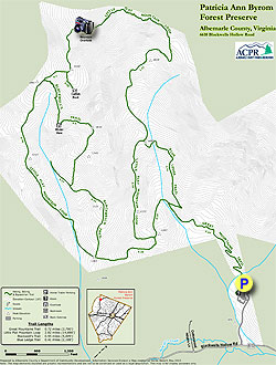
The drive to the trail head will remind you of many of the trails in SNP as you drive on Brown's Gap Turnpike and cross over Doyle's River.

  • Mile 0.0 โ€“ The trail begins just behind the information kiosk and starts to climb very quickly on the Great Mountain Trail. In 0.5 miles there will be a view of the creek on the left.

  • Mile 0.6 โ€“ Bear right onto the Blue Ledge Trail and very quickly you will bear to the left to stay on the trail.

  • Mile 1.0 โ€“ Small bridge, not far after the bridge bear right onto the Little Flat Mountain Loop trail.

  • Mile 1.4 โ€“ Reach a Picnic Table. Follow sign to continue up the Little Flat Mountain Loop trail. Note: From the picnic table if you hiked directly north you would reach Loft Mountain Campground in 1.4 miles, it would be one tough hike with over 1400' feet of elevation gain. There is no trail, we just mapped it out on our topo software from that point to see how close we were.

  • Mile 2.1 โ€“ Arrive at the Gibson Mountain Overlook looking south to the parking area and Blackwell Hollow. There is a nice bench to take in the views and catch your breath. Continue on the trail and quickly bear to the left and start heading down.

  • Mile 2.3 โ€“ Catfish Rock on the left, big rock, no views.

  • Mile 2.4 โ€“ Intersection with Blackwell's Trail. If you continued straight on the Little Flat Mountain Loop, it is a very steep descent. We did both trails and recommend Blackwell's Trail.

  • Mile 2.6 โ€“ Continue on Blackwell's Trail, there is supposed to be a Winter View here, we did not see much but maybe there was still too many leaves on the trees.

  • Mile 3.3 โ€“ Reach intersection of Little Flat Mountain Loop trail again and bear to the left.
    Note: This is where we hiked back up Little Flat Mountain Loop trail to see how tough it would be coming down that way and is why we made our recommendation at Mile 2.4.

  • Mile 3.6 โ€“ Little Flat Mountain Loop trail bears to the left, stay straight to continue to the Great Mountains Trail.

  • Mile 3.8 โ€“ Reach the Great Mountains Trail and continue down to the parking lot.

  • Mile 4.3 โ€“ Parking Lot, end of hike.

Explore 48 trails near Crozet, VA
  1. Parking

    38.221037, -78.649509
  2. Main Trailhead

    38.221071, -78.649557
No community routes found. To add your own hike as a Community Route for this Trail guide, leave a Trip Report with an attached GPX file.

Hazards

Ticks - Lyme Disease More Info (CDC)
Snakes
Poison Ivy/Oak

Seasons

All

Trip Reports

Trail Guide By:
HikingUpward user profile picture
4.3 miles / 6.9 km

Weather Forecast

In Crozet, VA

Explore Hiking Trails

You May Also Like

New York's Best Waterfalls - Whether you're planning a day hike, roadside stop, or a leisurely short walk, this guide provides hikers, travelers, and locals alike with 63 different locations to over 100 scenic waterfalls to help plan your next adventure!
Explore

New York's Best Waterfalls

Whether you're planning a day hike, roadside stop, or a leisurely short walk, this guide provides hikers, travelers, and locals alike with 63 different locations to over 100 scenic waterfalls to help plan your next adventure!

Read
25 Best Day Hikes in North Carolina - Discover the top 25 best day hikes in North Carolina, from breathtaking waterfalls to mountain peaks. Explore hidden gems, scenic views, and trails suitable for all skill levels, perfect for your next outdoor adventure.
Explore

25 Best Day Hikes in North Carolina

Discover the top 25 best day hikes in North Carolina, from breathtaking waterfalls to mountain peaks. Explore hidden gems, scenic views, and trails suitable for all skill levels, perfect for your next outdoor adventure.

Read

Before you boogie...

Find our trail guides useful? Consider becoming a Supporter to unlock perks!

MyHikes is an indie platform that makes exploring public trails easier for everyone. The platform has no investors, no ads, and is owned and operated by one person, Dave Miller. Dave has personally mapped and written over 1,800 trail guides on MyHikes for the public to explore. MyHikes has helped millions outdoor enthusiasts plan their next adventure.

But it takes a lot of time ๐Ÿ•ฆ, money ๐Ÿ’ฐ, work, and espresso shots โ˜• to run MyHikes, including hiking , mapping , writing , and publishing new trails with high-quality (accurate) information... along with software engineering (coding) the platform like building new features, website and mobile app development (iOS and Android), site maintainance . and much much more.

Supporters unlock website and mobile app perks with an annual one-time payment of $25 (you renew) ๐Ÿ˜Ž๐Ÿ‘. Or you can simply make a Donation of your choice. Otherwise, you can support us by telling your friends about MyHikes - both quick and free ๐ŸŽ‰

Admin user profile picture

Dave Miller
MyHikes Founder