Loading...

🎉 Enjoy a Free 7-Day Supporter Trial and Unlock Exclusive Perks — No Credit Card Required. Learn more.

Oak Knob Hike

Directions
Map
Pictures
Send to App
Distance:
7.6 Miles / 12.2 km
Type:
Loop
Difficulty:
Hard
Time to Hike:
3 hours, ~48 minutes
Features:
Surface Type:
Dirt
Park:
George Washington National Forest
Town:
Bridgewater, Virginia
Directions:
38.462277, -79.133921
Added:
February 17, 2025
Updated:
April 05, 2025
Copy Trail Link Hiking this trail? Send a friend or family member a link to this trail guide for your own safety. Hike at your own risk (disclaimer)
Loading...
Loading...
1,713'

Total Change
2,007'

Ascent
2,004'

Descent

Download the Trail Route for Offline Use

Supporters get exclusive access to download trail routes to the MyHikes app for offline use. Stay prepared on your adventure, even without an internet connection! Become a Supporter today to unlock this feature and hike with confidence.

Send to App

Oak Knob Hike

The Hone Quarry area is nestled in a quiet area of the GWNF just west of Harrisonburg VA. With two beautiful loop hikes, one up Oak Knob and Pond Knob with two overlooks, and the other on the opposite Hone Quarry Ridge also with a beautiful vista, makes this a great place to spend the weekend, and camp at the Hone Quarry Campground (vid).

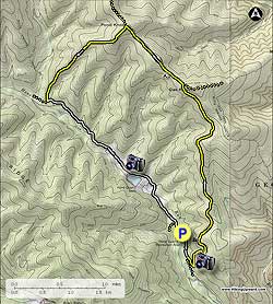
From the campground turn right and walk 0.2 miles down paved Hone Quarry Rd/FR62 to the Cliff Trail/429 trailhead and parking area. Turn left up the yellow blazed Cliff Trail as it ascends the mountain steeply making two switchbacks before arriving at the first valley overlook, then in another 0.3 miles the second overlook.

From the second overlook the Cliff Trail will becoming increasingly more rocky. Keep an eye out for Timber Rattlesnakes, especially as you cross the multiple rock slides that pass over the trail, as rocky areas are their favorite sunning spots.

There are also several views of the valley and the Hone Quarry Reservoir along the upper portion of the trail. As you near the ridge, the Cliff Trail will become more obscure, be vigilant to follow the yellow blazes. The Cliff Trail will end at the Meadow Knob Trail just west of Oak Knob, 2.3 miles form the second overlook.

Turn left on the wider yellow blazed Meadow Knob Trail. The trail will descend through the first saddle, then pass over a small knob, descend through another saddle, then climb very steeply to the summit of Pond Knob in 1.0 miles from the Cliff Trail.

At the summit of Pond Knob, turn left down the yellow blazed Pond Knob Trail as it descends very steeply for 1.5 miles where it ends at Hone Quarry Rd/FR 62. The Pond Knob Trail was designed to be a mountain biking trail, and has no switchbacks.

Turn left on gravel Hone Quarry Rd/FR62 and follow it 1.6 miles to the Hone Quarry Reservoir. Continue on Hone Quarry Rd/FR62 past the reservoir where it becomes paved, crosses Hone Quarry Run, then in 0.5 miles crosses the run again before arriving back at the campground.

Explore 46 trails near Bridgewater, VA
  1. Parking

    38.462277, -79.133921
  2. Main Trailhead

    38.462277, -79.133921
No community routes found. To add your own hike as a Community Route for this Trail guide, leave a Trip Report with an attached GPX file.

Hazards

Ticks - Lyme Disease More Info (CDC)
Snakes
Poison Ivy/Oak

Seasons

All

Blaze Color

Yellow

Trip Reports

Trail Guide By:
HikingUpward user profile picture
7.6 miles / 12.2 km

Weather Forecast

In Bridgewater, VA

Explore Hiking Trails

You May Also Like

New York's Best Waterfalls - Whether you're planning a day hike, roadside stop, or a leisurely short walk, this guide provides hikers, travelers, and locals alike with 63 different locations to over 100 scenic waterfalls to help plan your next adventure!
Explore

New York's Best Waterfalls

Whether you're planning a day hike, roadside stop, or a leisurely short walk, this guide provides hikers, travelers, and locals alike with 63 different locations to over 100 scenic waterfalls to help plan your next adventure!

Read
25 Best Day Hikes in North Carolina - Discover the top 25 best day hikes in North Carolina, from breathtaking waterfalls to mountain peaks. Explore hidden gems, scenic views, and trails suitable for all skill levels, perfect for your next outdoor adventure.
Explore

25 Best Day Hikes in North Carolina

Discover the top 25 best day hikes in North Carolina, from breathtaking waterfalls to mountain peaks. Explore hidden gems, scenic views, and trails suitable for all skill levels, perfect for your next outdoor adventure.

Read

Before you boogie...

Find our trail guides useful? Consider becoming a Supporter to unlock perks!

MyHikes is an indie platform that makes exploring public trails easier for everyone. The platform has no investors, no ads, and is owned and operated by one person, Dave Miller. Dave has personally mapped and written over 1,800 trail guides on MyHikes for the public to explore. MyHikes has helped millions outdoor enthusiasts plan their next adventure.

But it takes a lot of time 🕦, money 💰, work, and espresso shots ☕ to run MyHikes, including hiking , mapping , writing , and publishing new trails with high-quality (accurate) information... along with software engineering (coding) the platform like building new features, website and mobile app development (iOS and Android), site maintainance . and much much more.

Supporters unlock website and mobile app perks with an annual one-time payment of $25 (you renew) 😎👍. Or you can simply make a Donation of your choice. Otherwise, you can support us by telling your friends about MyHikes - both quick and free 🎉

Admin user profile picture

Dave Miller
MyHikes Founder