-
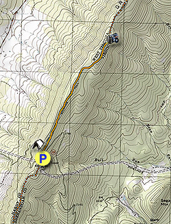
Mile 0.0 - From the parking area head north on the North Mountain Trail and immediately pass the only campsite on the hike.
There are several stone walls used by farmers in the early part of the 20th century to contain livestock on both sides of the trail. Once past this area there are good views to the east between the trees.
Shortly before arriving at the Nutmeg Point overlook, the trail is covered in moss in sections, then passes through an area of pine trees. -
Mile 2.0 - The overlook area is obvious as the views to the east open up and there is a short stunted pine where the trail veers left. There are views here of the Massanutten Range, Shenandoah National Park, and Bryce Ski Resort. Return the same way you came.
- Mile 3.4 - Arrive back at the parking area and VA 720
Nutmeg Point Hike
Know Before You Go
- Distance
- 3.4 mi
- Difficulty
- Easy
- Type
- Out-and-Back
- Est. Time
- 1.7 hrs
- Elev. Gain
- 284'
- Rating
- 0.0
- Added
- February 17, 2025
- Updated
- April 05, 2025
Weather Forecast
Don't let Google decide who you trust.


<strong>Trail map and elevation chart not rendering in print mode?</strong> Simply scroll to the trail map section, then try printing again!
34 m
87 m
87 m
Features
- Vista / Lookout Point
- Dogs
- Camping
Points of interest
-
Parking
38.860103, -78.804834 -
Main Trailhead
38.860103, -78.804834
Safety information
For your own safety: plan ahead, let someone know where you'll be, and hike at your own risk.
Hazards
Availability
Surface type
Trip Reports (Reviews)
Ready to help fellow hikers? Add a trip report to share your experience!


You may also like

25 Best Day Hikes in Virginia
Explore the top hikes in Virginia, from iconic trails in Shenandoah National Park to hidden gems in the Blue Ridge Mountains. Find your next unforgettable outdoor adventure.

25 Best Day Hikes in West Virginia
Discover 25 of the best day hikes in West Virginia, from scenic overlooks to wilderness trails—perfect for every level of hiker.

25 Best Day Hikes in North Carolina
Discover the top 25 best day hikes in North Carolina, from breathtaking waterfalls to mountain peaks. Explore hidden gems, scenic views, and trails suitable for all skill levels, perfect for your next outdoor adventure.

Best of the Alps: Hiking, Adventure & Scenery
Plan your ultimate European Alps adventure! Discover the best hiking trails, epic scenery, and villages in the Swiss Alps, Dolomites, Chamonix, and Lake Como.

