Loading...

🔥 End of Summer sale! 50% off on Supporter Accounts — now through September 1st. Learn More.

North River Gorge Hike

Directions
Map
Pictures
Send to App
Distance:
12.1 Miles / 19.5 km
Type:
Loop
Difficulty:
Hard
Time to Hike:
6 hours, ~5 minutes
Features:
Surface Type:
Dirt
Park:
George Washington National Forest
Town:
Mount Solon, Virginia
Directions:
38.359287, -79.175785
Added:
February 17, 2025
Updated:
April 05, 2025
Guide by:
Copy Trail Link Hiking this trail? Send a friend or family member a link to this trail guide for your own safety. Hike at your own risk (disclaimer)
Loading...
Loading...
1,085'

Total Change
1,767'

Ascent
1,760'

Descent

Download the Trail Route for Offline Use

Supporters get exclusive access to download trail routes to the MyHikes app for offline use. Stay prepared on your adventure, even without an internet connection! Become a Supporter today to unlock this feature and hike with confidence.

Send to App

North River Gorge Hike

The only loop hike that follows a river in the Todd Lake area of the GWNF, this hike has several nice view points, as well as a 4.2 mile hike along the banks of North River. The best time of the year for this circuit is in the late summer or early fall, when the river is lower. With eight fords of North River, it can be a challenge when the water is high.

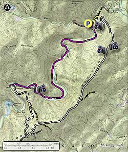
From the parking area head down the yellow blazed connector trail as it descends steeply to the purple blazed North River Gorge Trail in 0.1 miles. Turn left on the purple blazed trail and ford North River in 200 yards.

NOTE: You are required to ford North River 9 more times in the final 4.2 mile section of this hike. If the river is high, it could take significantly longer than the 6 hour hike time to complete.

After fording North River the purple blazed trail turns right, and a yellow blazed connector trail turns left down river. Turn left on the yellow blazed trail, and in 0.2 miles arrive at the intersection of the white blazed Wild Oak Trail.

Turn right uphill on the white blazed trail for 0.3 miles where it meets the intersection of the 100 yard out/back lookout trail. Take the lookout trail for the best vista on the hike. After returning to the white blazed trail, continue uphill as the trail becomes increasingly steep for another 1.6 miles before arriving at the final two good vista points on the hike. The first is to the east and Harrisonburg VA, and the second in another 100 yards, to the west.

From the ridge and second vista, continue another 0.8 miles over the hike high point on Lookout Mountain, then descend to the saddle in the ridge and intersection of yellow blazed trail TR513. Continue uphill on the white blazed trail for 1.2 miles passing over another rise and arrive at the un-maintained Bear Draft Trail. Continue straight on the white blazed trail for 0.3 miles, where the trail turns right downhill following a narrow Forestry Service (FS) road for 0.2 miles to the intersection of a wider FS road.

Turn right downhill following the the FS road as it winds down to the valley in 2.0 miles. Where the FS road veers left, near the valley floor, turn right onto an unmarked grass covered FS road, and in 100 yards pass through a closed gate. Follow the FS road down to the banks of North River, and intersection of the purple blazed North River Gorge Trail.

Turn right on the purple blazed trail and in 0.3 miles make the first of 9 fords across North River. There are several nice campsites on the trail, the first just after the second ford, and a large group campsite after the 8th ford 3.6 miles from the first campsite. From the large group campsite, after the 8th ford, continue on the right side of the river to the intersection of the yellow blazed trail in another 0.1 miles.

Re-cross North River staying on the purple blazed trail for 200 yards, then turn right uphill on the yellow blazed trail for the remaining 0.1 miles back to the parking area.

Explore 42 trails near Mount Solon, VA
  1. Parking

    38.359287, -79.175785
  2. Main Trailhead

    38.359224, -79.175892
No community routes found. To add your own hike as a Community Route for this Trail guide, leave a Trip Report with an attached GPX file.

Hazards

Ticks - Lyme Disease More Info (CDC)
Snakes
Poison Ivy/Oak

Seasons

All

Trip Reports (Reviews)

Rated 4.08 out of 5 based on 13 ratings.
By: JLP
12.1 miles / 19.5 km
October 06, 2018
Wonderful hike, love the ridgeline on the Wild Oak trail. A couple of things: one, this was my second attempt at doing this hike I tried a few weeks ago but turned around at the first crossing because the river looked high. You can look up the river gauge for the North River near Stokesville the gauge was reporting 4 ft when I decided it was too high, and about 2.5 ft when I tried again. 2.5 ft translated to being around my knees, and made for fun if occasionally cautious crossings. Two, people mentioned getting lost, so I brought the printed directions plus NatGeo map 791, and I still managed to misinterpret the map, so here's my advice: an indicator for when you hit FS 425/Lookout Mountain are two unhelpful signs (one says Lookout Mountain, the other offers distances to two FS roads) that is your intersection where you want to turn right and head downhill on the dirt road. Let me repeat: If you are coming down Wild Oak trail and you come to an intersection with a semi-legit looking road (semi-legit as far as FS roads go, it's really only 4wd friendly), THAT IS YOUR INTERSECTION, turn right. If you're walking on a road and not descending towards the river, you've missed it. Now, as for the "unmarked grass covered FS road," I ended up not taking it and following the dirt FS road down to an actual road and picking up the North River Gorge Trail near the campground. I did this intentionally because I wanted to use the vault toilet, but also because there was a pile of downed brush blocking what I thought was the unmarked road and I was too tired to check it out (I had a false start earlier with a different "unmarked road"). I'm pretty sure that brush-blocked spot was the unmarked road, though, and coming around the long way I *did* see where the unmarked road merged in the gate is there just as described, and it's recognizably a forest road at that point. The unmarked road is really just a shortcut, so don't worry if you miss it. Finally - I thought I'd have solitude, and I entirely did on the North River Gorge trail. As for the Wild Oak trail, I had the fun of sharing it with some utterly crazy people - it was part of the route for the Grindstone 100 race. Seriously, look it up. Crazy people.
Legacy Review
By: Hikermel
12.1 miles / 19.5 km
August 07, 2018
Not feeling like 12.5 miles today I did an out and back on North River Gorge Trail. Lots of rain recently so lots of water in the river making fording challenging! It's a great hike though, an easy walk in the woods really. I highly recommend wearing hiking sandals (I wear Keens) and having poles for crossing the river. I took just over four hours to hike up to the campground and back. I stopped once for lunch and a dip in the river and then again for another dip who could resist on a hot August day!
Legacy Review
By: Mike Taylor
12.1 miles / 19.5 km
January 19, 2018
What an incredible hike! This was my 3rd time hiking this loop and by far... the coldest. I went last spring and the water was rushing and deep... Then I went last fall and the waterflow was so minimal we didn't get our feet wet. This last weekend (19JAN2018) we hiked the loop and the water crossings were icy and cold. Water was about knee deep or less for most crossings, but at one point it looked VERY deep (waist) so we decided to parallel the river for a while and look for a better place to cross. Twice we were able to cross on fallen trees, but 9 times we had to cross the icy river IN THE WATER. We took our boots and socks off and crossed safely with hiking poles. Our feet warmed up fairly quickly once we got our wool socks and boots back on. (I'll try to add some pictures if this site allows me to.) Temps were 45 to 50 during the day at the ridge of the mountain, but much colder down in the valley. Happy trails.. I'll be back in the spring for a water crossing trip!
Legacy Review

Weather Forecast

In Mount Solon, VA

Explore Hiking Trails

You May Also Like

New York's Best Waterfalls - Whether you're planning a day hike, roadside stop, or a leisurely short walk, this guide provides hikers, travelers, and locals alike with 63 different locations to over 100 scenic waterfalls to help plan your next adventure!
Explore

New York's Best Waterfalls

Whether you're planning a day hike, roadside stop, or a leisurely short walk, this guide provides hikers, travelers, and locals alike with 63 different locations to over 100 scenic waterfalls to help plan your next adventure!

Read
25 Best Day Hikes in North Carolina - Discover the top 25 best day hikes in North Carolina, from breathtaking waterfalls to mountain peaks. Explore hidden gems, scenic views, and trails suitable for all skill levels, perfect for your next outdoor adventure.
Explore

25 Best Day Hikes in North Carolina

Discover the top 25 best day hikes in North Carolina, from breathtaking waterfalls to mountain peaks. Explore hidden gems, scenic views, and trails suitable for all skill levels, perfect for your next outdoor adventure.

Read

Before you boogie...

Find our trail guides useful? Consider becoming a Supporter to unlock perks!

MyHikes is an indie platform that makes exploring public trails easier for everyone. The platform has no investors, no ads, and is owned and operated by one person, Dave Miller. Dave has personally mapped and written over 1,800 trail guides on MyHikes for the public to explore. MyHikes has helped millions outdoor enthusiasts plan their next adventure.

But it takes a lot of time 🕦, money 💰, work, and espresso shots ☕ to run MyHikes, including hiking , mapping , writing , and publishing new trails with high-quality (accurate) information... along with software engineering (coding) the platform like building new features, website and mobile app development (iOS and Android), site maintainance . and much much more.

Supporters unlock website and mobile app perks with an annual one-time payment of $25 (you renew) 😎👍. Or you can simply make a Donation of your choice. Otherwise, you can support us by telling your friends about MyHikes - both quick and free 🎉

Admin user profile picture

Dave Miller
MyHikes Founder