The Niagara Falls Trail at Niagara Parks in Niagara Falls, Ontario is an easy 2 km (1.3-mile) out-and-back walk that leads to stunning views of Horseshoe Falls, Bridal Veil, and American Falls from the Canadian side of the Niagara Gorge.
Trail
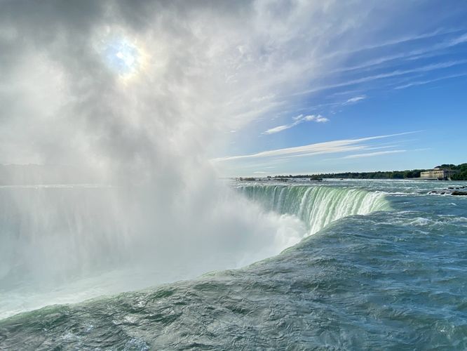
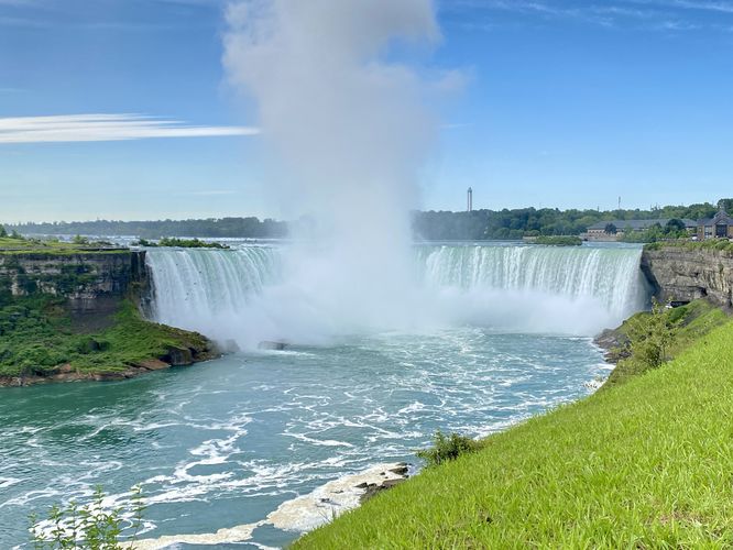
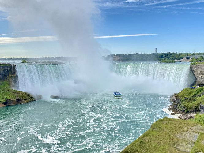
This trail begins at the main parking lot for Niagara Falls, crosses the street, and passes the Table Rock Center which sits at the top of Horseshoe Falls. On your way in toward the top of Horseshoe Falls, you'll find the turquoise waters of the Niagara River's rapids upstream before the water slips over the cliffs. Visitors will find views of the top of Horseshoe Falls within the first 0.2 km of the trail where you can watch the river quietly slip over the cliff's edge. The views get even-better once you make your way to 0.25 km into the trail where you'll find a sweeping 180-degree view of Horseshoe Falls with its column-like cloud of mist permanently suspended in the middle of the gorge.
After passing the top of Horseshoe Falls, the views only get better as you make your way north along the trail. The trail's safety railing provides more views with sheer cliffs until you make it to the Table Rock marker.
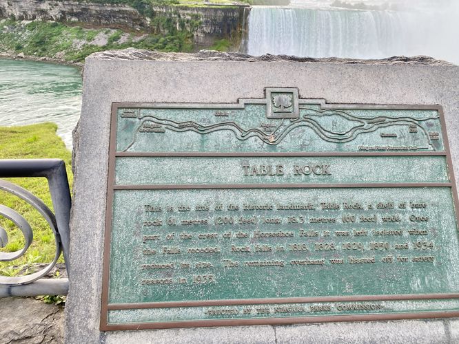
Table Rock Historical Marker - 0.5 km (0.3-miles)
Table Rock is a feature of the Niagara Gorge where shelf-like bedrock jutted out and was once part of the crest of Horseshoe Falls until the waterfall receded. This used to be a popular destination for visitors to enjoy the waterfall, circa 1800s, until Table Rock started crumbling away with rockfalls in the 1800s and early 1900s. In 1935, the remaining section of Table Rock was blasted and destroyed for safety reasons. Today, you can still find small sections of the rock shelf.
Horseshoe Falls View - 0.66 km (0.4-miles)
Around 0.66 km, visitors will find a stunning view of Horseshoe Falls in its full glory plummeting into the Niagara Gorge. The view from this lookout point is one of the best downstream views of the waterfall, but it can certainly be enjoyed with very-similar views along other sections of the trail.
American Falls Views - 0.93 km to 1 km (0.6 to 0.65-miles)
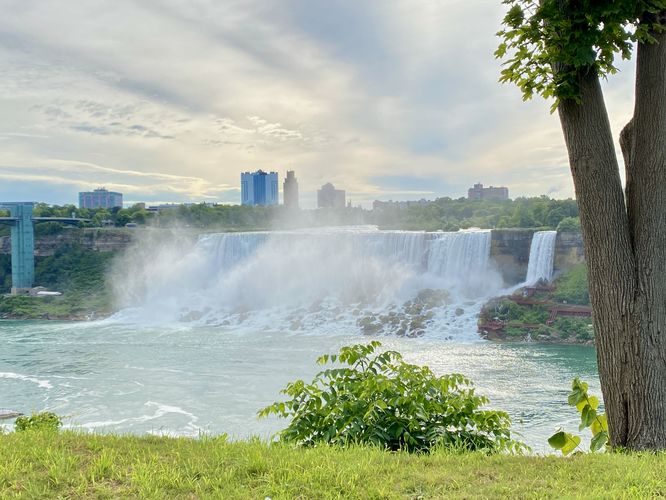
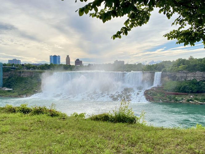
Around 0.93 km to 1 km, the best views of American Falls and Bridal Veil Falls come into view from the trail. At 1 km (0.65-miles), the view of American Falls is almost directly across the Niagara Gorge. During our walk here in the early morning in August 2024, we had to use a tree's shade to block out the early-morning sun to get a decent view of American and Bridal Veil Falls; however, you'll find great views of the waterfalls up and the down river from this point.
At 1 km, we decided to hike back to parking to further explore the gorge from the American side. If you wish to explore the New York side of Niagara Gorge, feel free to check out our trail guide for the Niagara Falls Hike (American Side).
Universal Accessibility
This trail is universally-accessible from the parking lot all the way to the American Falls lookout and back. The trail follows a smooth paved surface the entire way.
Parking & Fees
Visitors will find a gigantic parking lot at the coordinates provided. The lot can fit many many dozens of vehicles. As of August 2024, there's a $35/vehicle parking fee.
Popularity
This is by far one of the most-popular trails in the area all times of the year. During the winter, Niagara's appeal drops-off due to the freezing temperatures, but you can expect people on the trail virtually year-round. At night, the waterfalls are lit-up with colorful lights which are generally turned-on around sunset and turn off around 2AM. The night lighting is often even-more popular than other hours of the day. If you wish to explore Niagara Falls without too much foot traffic, plan to show-up early in the morning.
Trail
This trail begins at the main parking lot for Niagara Falls, crosses the street, and passes the Table Rock Center which sits at the top of Horseshoe Falls. On your way in toward the top of Horseshoe Falls, you'll find the turquoise waters of the Niagara River's rapids upstream before the water slips over the cliffs. Visitors will find views of the top of Horseshoe Falls within the first 0.2 km of the trail where you can watch the river quietly slip over the cliff's edge. The views get even-better once you make your way to 0.25 km into the trail where you'll find a sweeping 180-degree view of Horseshoe Falls with its column-like cloud of mist permanently suspended in the middle of the gorge.
After passing the top of Horseshoe Falls, the views only get better as you make your way north along the trail. The trail's safety railing provides more views with sheer cliffs until you make it to the Table Rock marker.
Table Rock Historical Marker - 0.5 km (0.3-miles)
Table Rock is a feature of the Niagara Gorge where shelf-like bedrock jutted out and was once part of the crest of Horseshoe Falls until the waterfall receded. This used to be a popular destination for visitors to enjoy the waterfall, circa 1800s, until Table Rock started crumbling away with rockfalls in the 1800s and early 1900s. In 1935, the remaining section of Table Rock was blasted and destroyed for safety reasons. Today, you can still find small sections of the rock shelf.
Horseshoe Falls View - 0.66 km (0.4-miles)
Around 0.66 km, visitors will find a stunning view of Horseshoe Falls in its full glory plummeting into the Niagara Gorge. The view from this lookout point is one of the best downstream views of the waterfall, but it can certainly be enjoyed with very-similar views along other sections of the trail.
American Falls Views - 0.93 km to 1 km (0.6 to 0.65-miles)
Around 0.93 km to 1 km, the best views of American Falls and Bridal Veil Falls come into view from the trail. At 1 km (0.65-miles), the view of American Falls is almost directly across the Niagara Gorge. During our walk here in the early morning in August 2024, we had to use a tree's shade to block out the early-morning sun to get a decent view of American and Bridal Veil Falls; however, you'll find great views of the waterfalls up and the down river from this point.
At 1 km, we decided to hike back to parking to further explore the gorge from the American side. If you wish to explore the New York side of Niagara Gorge, feel free to check out our trail guide for the Niagara Falls Hike (American Side).
Universal Accessibility
This trail is universally-accessible from the parking lot all the way to the American Falls lookout and back. The trail follows a smooth paved surface the entire way.
Parking & Fees
Visitors will find a gigantic parking lot at the coordinates provided. The lot can fit many many dozens of vehicles. As of August 2024, there's a $35/vehicle parking fee.
Popularity
This is by far one of the most-popular trails in the area all times of the year. During the winter, Niagara's appeal drops-off due to the freezing temperatures, but you can expect people on the trail virtually year-round. At night, the waterfalls are lit-up with colorful lights which are generally turned-on around sunset and turn off around 2AM. The night lighting is often even-more popular than other hours of the day. If you wish to explore Niagara Falls without too much foot traffic, plan to show-up early in the morning.