Newspaper Rock Petroglyphs at the Newspaper Rock Archeological Site near Monticello, Utah is an easy universally-accessible 0.1-mile out-and-back walk that features ancient 2,000 year old petroglpyhs.
This is not a hike but rather a very short out-and-back walk that leads to the archeological site known as Newspaper Rock. Newspaper Rock was used for thousands of years by people to convey messages, stories, or other types of information.
Universal Access
This short out-and-back pathway is universally accessible as of September 2023.
Parking
Visitors will find a medium-sized parking lot at the coordinates provided, large enough to fit about a dozen vehicles.
Pets
Dogs are allowed only if leashed and must be cleaned up after.
History
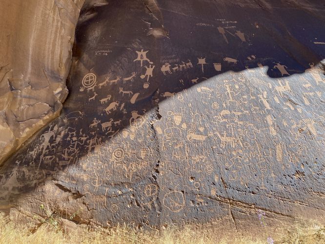
Newspaper Rock is a petroglyph panel etched in sandstone that records approximately 2,000 years of early human activity. Prehistoric peoples, probably from the Archaic, Basketmaker, Fremont, and Pueblo cultures, etched on the rock from B.C. time to A.D. 1300. In historic times, Ute and Navajo people, as well as European Americans made their contributions. In interpreting the figures on the rock, scholars are undecided as to their meaning or have yet to decipher them. In Navajo, the rock is called "Tse' Hane'" (Rock that tells a story). Unfortunately, we do not know if the figures represent storytelling, doodling, hunting magic, clan symbols, ancient graffiti or something else. Without a true understanding of the petroglyphs, much is left for individual interpretation. Newspaper Rock is listed in the National Register of Historic Places. Please continue to preserve it.
This is not a hike but rather a very short out-and-back walk that leads to the archeological site known as Newspaper Rock. Newspaper Rock was used for thousands of years by people to convey messages, stories, or other types of information.
Universal Access
This short out-and-back pathway is universally accessible as of September 2023.
Parking
Visitors will find a medium-sized parking lot at the coordinates provided, large enough to fit about a dozen vehicles.
Pets
Dogs are allowed only if leashed and must be cleaned up after.
History
Newspaper Rock is a petroglyph panel etched in sandstone that records approximately 2,000 years of early human activity. Prehistoric peoples, probably from the Archaic, Basketmaker, Fremont, and Pueblo cultures, etched on the rock from B.C. time to A.D. 1300. In historic times, Ute and Navajo people, as well as European Americans made their contributions. In interpreting the figures on the rock, scholars are undecided as to their meaning or have yet to decipher them. In Navajo, the rock is called "Tse' Hane'" (Rock that tells a story). Unfortunately, we do not know if the figures represent storytelling, doodling, hunting magic, clan symbols, ancient graffiti or something else. Without a true understanding of the petroglyphs, much is left for individual interpretation. Newspaper Rock is listed in the National Register of Historic Places. Please continue to preserve it.