Loading...

Distance:
0 Miles / 0 km
Type:
Out-and-Back
Difficulty:
Easy
Time to Hike:
~5 minutes
Features:
Surface Type:
Universal Access
Park:
Capitol Reef National Park
Town:
Fruita, Utah
Directions:
38.287358, -111.221712
Added:
September 26, 2023
Updated:
October 04, 2023
Loading...
Loading...
1 '

Total Change
1 '

Ascent
1 '

Descent

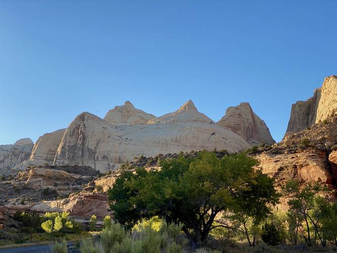
The Navajo Dome Viewpoint at Capitol Reef National Park near Fruita, Utah is a universally-accessible roadside vista of the rock formation known as Navajo Dome.

This is not a hike but rather a short roadside stop that includes a beautiful view of Navajo Dome. Visitors will get a view right from the parking turnout and don't need to walk very far to get a good view of the dome.

Universal Access
This viewpoint is universally accessible as it exists within a paved parking turnout.

Parking
Visitors will find a large parking lot at the coordinates provided.

Pets
Dogs are allowed here and at other public parking lots within the park. Dogs must be leashed and cleaned up after. Please read more about Capitol Reef National Park's pet rules.

Explore 20 trails near Fruita, UT
  1. Parking

    38.287358, -111.221712
  2. Main Trailhead

    38.287389, -111.221764
  3. Navajo Dome Viewpoint at Capitol Reef National Park

    38.287461, -111.221808
    Navajo Dome Viewpoint at Capitol Reef National Park
No community routes found. To add your own hike as a Community Route for this Trail guide, leave a Trip Report with an attached GPX file.

Hazards

Snakes

Seasons

All

Photo Albums

1 Trip Report

No Star-Ratings
Write-up by:
Admin user profile picture
0 miles / 0 km
Trail added
September 26, 2023
Hiked on
September 26, 2023
Updated on
October 04, 2023

Weather Forecast

In Fruita, UT

Explore Hiking Trails

New Hikes

Sewee Shell Ring Trail
1.1 Miles
1.8 km
Easy
Loop
Cottonwood Falls Loop
1.2 Miles
1.9 km
Moderate
Loop
Lower Ammonoosuc Falls Trail
1.1 Miles
1.8 km
Easy
Out-and-Back
Upper Rattler Run Falls
1.9 Miles
3.1 km
Hard
Out-and-Back

Before you leave...

MyHikes is an indie web platform aimed to make exploring public trails easier for everyone. The site has no investors and is owned and operated by one person, Dave Miller (Founder & Admin). As the Founder, main contributor, and doer-of-all-things for MyHikes, I share my trips with over-detailed write-ups for fun on a volunteer basis and I believe that public trail information should be available to everyone.

It takes a lot of time 🕦, money 💰, and effort (including espresso shots ☕) to run MyHikes, including hiking , mapping , writing , and publishing new trails with high-quality content... along with building new features, moderating, site maintainance, and app development for iOS and Android . I simply ask that if you find MyHikes' trail guides helpful to please consider becoming a Supporter to help keep the site, iOS, and Android apps available to everyone.

Supporters unlock website and in-app perks with a one-time payment of $25 (you renew) 😎👍. Or you can simply make a Donation of your choice without a MyHikes user account. Otherwise, telling your friends about MyHikes is the next-best thing - both quick and free 🎉

Thanks for visiting MyHikes and have a great hike!️

Admin user profile picture

Dave Miller
MyHikes Founder & Admin