Loading...

🎉 Enjoy a Free 7-Day Supporter Trial and Unlock Exclusive Perks — No Credit Card Required. Learn more.

Murphy Chambers Farm Hike

Directions
Map
Pictures
Send to App
Distance:
1.7 Miles / 2.7 km
Type:
Loop
Difficulty:
Easy
Time to Hike:
~51 minutes
Features:
Surface Type:
Dirt
Park:
Harpers Ferry National Historical Park
Town:
Harpers Ferry, West Virginia
Directions:
39.312631, -77.760805
Added:
March 20, 2025
Updated:
April 06, 2025
Copy Trail Link Hiking this trail? Send a friend or family member a link to this trail guide for your own safety. Hike at your own risk (disclaimer)
Loading...
Loading...
90'

Total Change
197'

Ascent
198'

Descent

Download the Trail Route for Offline Use

Supporters get exclusive access to download trail routes to the MyHikes app for offline use. Stay prepared on your adventure, even without an internet connection! Become a Supporter today to unlock this feature and hike with confidence.

Send to App

Murphy Chambers Farm Hike

Part of the Harpers Ferry National Historic Park, the Murphy Chambers Farm became a battlefield during the Civil War. Edmund H. Chambers bought the farm in 1848. Although Chambers was a loyal Unionist, the Union confiscated his farm in 1862 forcing the family from their home. The U.S. Army arranged for an appraisal of the farm in the event of damage. At war's end Chambers found the property destroyed and filed a claim demanding restitution. In 1888, 23 years after the end of the war he was still trying to settle his claim. There is no evidence he was ever paid. He died in 1890. - Harpers Ferry/NHP.

This is an easy walk with well maintained trails. There are three other hikes in the Harpers Ferry area: School House Ridge, Loudoun Heights and the Maryland Heights hikes.

Battle of Harpers Ferry - September 12-15, 1862

As Robert E. Lee advanced into Maryland with the Army of Northern Virginia, he ordered Thomas Jonathan 'Stonewall' Jackson to capture the garrison at Harpers Ferry to secure a supply line back to Virginia. Jackson's troops located on School House Ridge were under the command of A.P. Hill, Lawton, and J.R. Jones. McLaws commanded on Maryland Heights, and Walker and Crutchfield on Loudoun Heights. The first day of fighting saw heavy cannon fire but not advancement by the Confederate forces on Harpers Ferry. To press the battle after a second day of fighting Jackson ordered A.P. Hill to flank Miles's Union troops to the south of their location on Bolivar Heights. That night A.P. Hill moved into position next to the Shenandoah River with 3,500 troops and 20 cannon.

After heavy bombardment on the third day by the Confederate troops Union Col. Dixon S. Miles realized the fight was hopeless and surrendered to Jackson's forces, but died of wounds from Cannon fire before the surrender took affect. Although by Civil War standards the loss of life was considerably fewer, with 44 Union troops and 39 Confederate troops killed, the battle saw the largest surrender of Union troops in one engagement with 12,000 becoming prisoners of war.

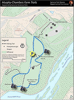
  • Chambers Farmhouse - Wide fields with a reconstruction of the original farmhouse

  • Confederate Cannon Line - A.P. Hill line of Confederate cannon

  • Earthworks and View of the
    Shenandoah River
    - Built by Union General Philip Sheridan in 1864 to prevent Confederates from skirting undetected along the Shenandoah River

  • John Browns Fort Foundation - Foundation outline of the John Browns Fort

  • Harpers Ferry View - View towards Harpers Ferry from the northerly section of the farm

Explore 32 trails near Harpers Ferry, WV
  1. Parking

    39.312631, -77.760805
  2. Main Trailhead

    39.312584, -77.760844
No community routes found. To add your own hike as a Community Route for this Trail guide, leave a Trip Report with an attached GPX file.

Hazards

Ticks - Lyme Disease More Info (CDC)

Seasons

All

Trip Reports

Trail Guide By:
HikingUpward user profile picture
1.7 miles / 2.7 km

Weather Forecast

In Harpers Ferry, WV

Explore Hiking Trails

You May Also Like

Colorado's Million Dollar Highway - Plan a day's drive adventure along the iconic Million Dollar Highway in Colorado. Explore the best short trails, roadside stops, waterfalls, vistas, ghost towns, and hot springs within a ~6 hour road trip.
Explore

Colorado's Million Dollar Highway

Plan a day's drive adventure along the iconic Million Dollar Highway in Colorado. Explore the best short trails, roadside stops, waterfalls, vistas, ghost towns, and hot springs within a ~6 hour road trip.

Read
New York's Best Waterfalls - Whether you're planning a day hike, roadside stop, or a leisurely short walk, this guide provides hikers, travelers, and locals alike with 63 different locations to over 100 scenic waterfalls to help plan your next adventure!
Explore

New York's Best Waterfalls

Whether you're planning a day hike, roadside stop, or a leisurely short walk, this guide provides hikers, travelers, and locals alike with 63 different locations to over 100 scenic waterfalls to help plan your next adventure!

Read

Before you boogie...

Find our trail guides useful? Consider becoming a Supporter to unlock perks!

MyHikes is an indie platform that makes exploring public trails easier for everyone. The platform has no investors, no ads, and is owned and operated by one person, Dave Miller. Dave has personally mapped and written over 1,800 trail guides on MyHikes for the public to explore. MyHikes has helped millions outdoor enthusiasts plan their next adventure.

But it takes a lot of time 🕦, money 💰, work, and espresso shots ☕ to run MyHikes, including hiking , mapping , writing , and publishing new trails with high-quality (accurate) information... along with software engineering (coding) the platform like building new features, website and mobile app development (iOS and Android), site maintainance . and much much more.

Supporters unlock website and mobile app perks with an annual one-time payment of $25 (you renew) 😎👍. Or you can simply make a Donation of your choice. Otherwise, you can support us by telling your friends about MyHikes - both quick and free 🎉

Admin user profile picture

Dave Miller
MyHikes Founder