Loading...

๐ŸŽ‰ Enjoy a Free 7-Day Supporter Trial and Unlock Exclusive Perks โ€” No Credit Card Required. Learn more.

Muir Beach Overlook Trail

Directions
Map
Pictures
Send to App
Distance:
0.2 Miles / 0.3 km
Type:
Out-and-Back
Difficulty:
Easy
Time to Hike:
~6 minutes
Features:
Surface Type:
Dirt
Park:
Muir Beach
Town:
Sausalito, California
Directions:
37.86312, -122.585753
Added:
February 06, 2020
Updated:
February 06, 2020
Copy Trail Link Hiking this trail? Send a friend or family member a link to this trail guide for your own safety. Hike at your own risk (disclaimer)
Loading...
Loading...
63'

Total Change
65'

Ascent
65'

Descent

Download the Trail Route for Offline Use

Supporters get exclusive access to download trail routes to the MyHikes app for offline use. Stay prepared on your adventure, even without an internet connection! Become a Supporter today to unlock this feature and hike with confidence.

Send to App

Muir Beach Overlook Trail

The Muir Beach Overlook Trail at Muir Beach in California is an easy 0.2-mile out-and-back trail that features stunning views of California's coast along with views of Muir Beach to the south.

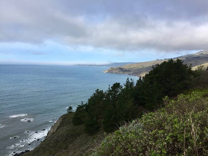
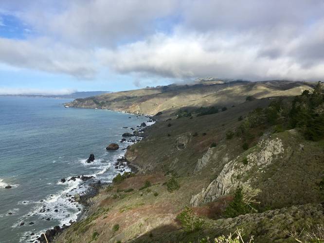
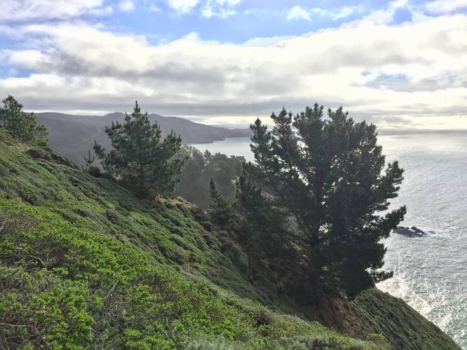
This short and easy trail follows a very steep ridge that leads out to a lookout point at the end. The trail is guarded by a fence and has a few sets of stairs that lead out to the lookout point, so the trail is not fully accessible. The views to the north are mostly sea cliffs that span the length of Mount Tamalpais State Park. Directly to the south are views of Muir Beach and more of California's coastal cliffs.

History
During the early stages of the United States entry into WWII, the government set out to fortify land around the San Francisco Bay Area from enemy ships. "Fire control" stations were built along the coast which housed soldiers on the lookout for enemy ships. Equipped with a very powerful spotting scope, they could relay ship coordinates to a central communications and plotting center, so powerful guns nearby could take accurate aim at their targets. Today, what's leftover are historic base end stations nicknamed "gopher holes" by the soldiers. Two of them served Fort Miley south of Ocean Beach in San Francisco, and the south was assigned to a minefield, which paralleled the shipping channel along the Marin shore.

Parking
Hikers will find parking at the coordinates provided. The lot is large enough to fit about one dozen vehicles.

Pets
Dogs are allowed if leashed and their waste must be carried out by the hiker.
Explore 28 trails near Sausalito, CA
  1. Parking

    37.86312, -122.585753
  2. Main Trailhead

    37.862936, -122.585782
  3. View / Overlook / Vista

    37.8628, -122.585817
    View / Overlook / Vista
  4. View north toward Mount Tamalpais State Park

    37.861808, -122.58645
    View north toward Mount Tamalpais State Park
  5. View south toward Muir Beach

    37.861797, -122.586464
    View south toward Muir Beach
No community routes found. To add your own hike as a Community Route for this Trail guide, leave a Trip Report with an attached GPX file.

Hazards

Ticks - Lyme Disease More Info (CDC)

Seasons

All

Trip Reports

Trail Guide By:
Admin user profile picture
0.2 miles / 0.3 km
0.2 miles / 0.3 km
January 30, 2020
Hiking

Weather Forecast

In Sausalito, CA

Explore Hiking Trails

You May Also Like

Colorado's Million Dollar Highway - Plan a day's drive adventure along the iconic Million Dollar Highway in Colorado. Explore the best short trails, roadside stops, waterfalls, vistas, ghost towns, and hot springs within a ~6 hour road trip.
Explore

Colorado's Million Dollar Highway

Plan a day's drive adventure along the iconic Million Dollar Highway in Colorado. Explore the best short trails, roadside stops, waterfalls, vistas, ghost towns, and hot springs within a ~6 hour road trip.

Read
Glacier's Going-to-the-Sun Road - Discover the breathtaking beauty of Glacier National Park along the iconic Going-to-the-Sun Road. From stunning roadside stops to picturesque waterfalls and vistas, this engineering marvel offers endless opportunities for exploration.
Explore

Glacier's Going-to-the-Sun Road

Discover the breathtaking beauty of Glacier National Park along the iconic Going-to-the-Sun Road. From stunning roadside stops to picturesque waterfalls and vistas, this engineering marvel offers endless opportunities for exploration.

Read
New York's Best Waterfalls - Whether you're planning a day hike, roadside stop, or a leisurely short walk, this guide provides hikers, travelers, and locals alike with 63 different locations to over 100 scenic waterfalls to help plan your next adventure!
Explore

New York's Best Waterfalls

Whether you're planning a day hike, roadside stop, or a leisurely short walk, this guide provides hikers, travelers, and locals alike with 63 different locations to over 100 scenic waterfalls to help plan your next adventure!

Read

Before you boogie...

Find our trail guides useful? Consider becoming a Supporter to unlock perks!

MyHikes is an indie platform that makes exploring public trails easier for everyone. The platform has no investors, no ads, and is owned and operated by one person, Dave Miller. Dave has personally mapped and written over 1,800 trail guides on MyHikes for the public to explore. MyHikes has helped millions outdoor enthusiasts plan their next adventure.

But it takes a lot of time ๐Ÿ•ฆ, money ๐Ÿ’ฐ, work, and espresso shots โ˜• to run MyHikes, including hiking , mapping , writing , and publishing new trails with high-quality (accurate) information... along with software engineering (coding) the platform like building new features, website and mobile app development (iOS and Android), site maintainance . and much much more.

Supporters unlock website and mobile app perks with an annual one-time payment of $25 (you renew) ๐Ÿ˜Ž๐Ÿ‘. Or you can simply make a Donation of your choice. Otherwise, you can support us by telling your friends about MyHikes - both quick and free ๐ŸŽ‰

Admin user profile picture

Dave Miller
MyHikes Founder