The Mt. Orient Loop in Pelham, Massachusetts is a moderate 2.3-mile loop hike that features views of the Holyoke Range and leads near the summit of the mountain.
Hike Description
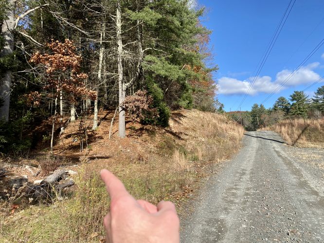
This hike begins along North Valley Road in Pelham, at the coordinates provided and heads up the very-steep trail that runs under the power lines. The start to the hike is steep, but the rest of the hike is moderate at worst. The trail will follow under the power lines, so once you're up off of the road just hike the power line trail for a short while.
Left-Hand Turn - Mile 0.35
The trail follows the power lines from the road for about 0.35 miles to reach a junction on the left-hand side. Note that you'll pass an earlier left-hand trail junction at the first power line pillars -- skip that turn to reach the 2nd turn. Once on this trail, it will lead to a summit-adjacent trail junction near the top of Mt. Orient.
Hiking to Mt. Orient summit - Mile 0.35 to 1
From mile 0.35 to mile 1, hikers will head up the mountain along a moderately-steep trail. This forested path doesn't have much of anything to see or note; however, it might be decent hunting as a lot of the forest floor is open. At mile 1, hikers will reach a trail junction with the Robert Frost Trail -- take a left-hand turn here. Note that you're just below the summit of Mt. Orient by just a short walk away, hence the "summit" feature on this hike; however, unless you go out of your way, you will not hike to the true summit of Mt. Orient when following this route. From what I understand, there's nothing up there.
Robert Frost Trail to Mt. Orient Vista - Mile 1 to 1.55
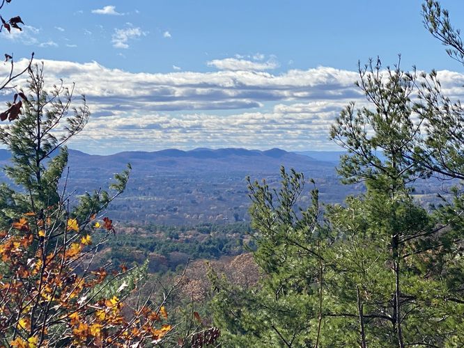
Once on the Robert Frost Trail, hikers will head southward to reach the vista that sits on the slopes of Mt. Orient. Along the way, the trail will pass a steep grade of mountain slopes and some interesting rocky outcroppings. At mile 1.55, hikers will finally reach the vista on the southwestern slope of Mt. Orient. Hikers will get views of the Holyoke Range, including the 7 Sisters, and valley views into the Amherst area. The view here is accompanied by a large rock outcropping. During the winter, this outcropping can be icy -- watch out.
Robert Frost Trail to Path Out - Mile 1.55 to 1.75
The section of trail after the vista is noteworthy as it connects the rest of the Robert Frost Trail segment to the trail that leads out; however, on the way is a steep, rocky ledge that must be scrambled down. During the Winter or shoulder seasons with ice, this part of the hike is by far the most dangerous and sketchy -- ice spikes are recommended during the Winter and even beefier crampons and an ice axe could really help the ascent or descent here (depending on which way you hike it). Just below the ledge descent of the mountain is a 3-way trail junction -- head to the far-left trail here to follow this pathway out back to the power lines. You'll know you're on the right path when hiking past "no trespassing" signs that line the south side of the trail.
Power Lines to Parking - Mile 2.1 to 2.3
At mile 2.1 take a right-hand turn to head back down the power lines. Finally, hike down the steep hillside to reach the parking lot and complete this hike for 2.3 miles.
Parking
Hikers will find a small parking turnout at the coordinates provided, located on the north side of North Valley Road. The turnout is large enough to fit a few vehicles.
Pets
Dogs are allowed only if leashed and must be cleaned up after.
Warning
Hunting: This area allowed hunting during open season, generally from October through January each year. During open season, it's best to wear blaze orange to make your presence known.
Hike Description
This hike begins along North Valley Road in Pelham, at the coordinates provided and heads up the very-steep trail that runs under the power lines. The start to the hike is steep, but the rest of the hike is moderate at worst. The trail will follow under the power lines, so once you're up off of the road just hike the power line trail for a short while.
Left-Hand Turn - Mile 0.35
The trail follows the power lines from the road for about 0.35 miles to reach a junction on the left-hand side. Note that you'll pass an earlier left-hand trail junction at the first power line pillars -- skip that turn to reach the 2nd turn. Once on this trail, it will lead to a summit-adjacent trail junction near the top of Mt. Orient.
Hiking to Mt. Orient summit - Mile 0.35 to 1
From mile 0.35 to mile 1, hikers will head up the mountain along a moderately-steep trail. This forested path doesn't have much of anything to see or note; however, it might be decent hunting as a lot of the forest floor is open. At mile 1, hikers will reach a trail junction with the Robert Frost Trail -- take a left-hand turn here. Note that you're just below the summit of Mt. Orient by just a short walk away, hence the "summit" feature on this hike; however, unless you go out of your way, you will not hike to the true summit of Mt. Orient when following this route. From what I understand, there's nothing up there.
Robert Frost Trail to Mt. Orient Vista - Mile 1 to 1.55
Once on the Robert Frost Trail, hikers will head southward to reach the vista that sits on the slopes of Mt. Orient. Along the way, the trail will pass a steep grade of mountain slopes and some interesting rocky outcroppings. At mile 1.55, hikers will finally reach the vista on the southwestern slope of Mt. Orient. Hikers will get views of the Holyoke Range, including the 7 Sisters, and valley views into the Amherst area. The view here is accompanied by a large rock outcropping. During the winter, this outcropping can be icy -- watch out.
Robert Frost Trail to Path Out - Mile 1.55 to 1.75
The section of trail after the vista is noteworthy as it connects the rest of the Robert Frost Trail segment to the trail that leads out; however, on the way is a steep, rocky ledge that must be scrambled down. During the Winter or shoulder seasons with ice, this part of the hike is by far the most dangerous and sketchy -- ice spikes are recommended during the Winter and even beefier crampons and an ice axe could really help the ascent or descent here (depending on which way you hike it). Just below the ledge descent of the mountain is a 3-way trail junction -- head to the far-left trail here to follow this pathway out back to the power lines. You'll know you're on the right path when hiking past "no trespassing" signs that line the south side of the trail.
Power Lines to Parking - Mile 2.1 to 2.3
At mile 2.1 take a right-hand turn to head back down the power lines. Finally, hike down the steep hillside to reach the parking lot and complete this hike for 2.3 miles.
Parking
Hikers will find a small parking turnout at the coordinates provided, located on the north side of North Valley Road. The turnout is large enough to fit a few vehicles.
Pets
Dogs are allowed only if leashed and must be cleaned up after.
Warning
Hunting: This area allowed hunting during open season, generally from October through January each year. During open season, it's best to wear blaze orange to make your presence known.