There’s the hard way to ascend Mt. Mitchell, and then there’s the really hard way to ascend Mt. Mitchell. If the challenge of the Mt. Mitchell Trail isn’t enough for you, then tackle the Black Mountain Crest Trail. Oh by the way, you’ll also cross five peaks over 6,000 feet, including the 2nd tallest mountain in the east, Mt. Craig. Lovingly nicknamed the “Death March” by North Carolinians, this hike may be the toughest you’ll encounter in NC for the distance covered. The crest trail may be beautiful and a peakbagger’s dream, but do not underestimate the difficulty of tackling this from the northern trail head at Bowlens Creek.
You’ll begin the hike with a lung-busting ascent of 3,000 feet in 4 miles to the shoulder of Celo Knob. The trail will ease up for 1.5 miles as you get big views from the ridgeline before beginning its rollercoaster journey along the Central Blacks for the last 6 miles. While there aren’t any big climbs on the latter half of the trip, the crest trail plows straight up and down into narrow gaps hundreds of feet below the peaks. The trail is rocky, eroded, and always tricky footing. The hike described here is a shuttle in the most difficult direction. If you start at Mt. Mitchell the elevation gain is <3,000 feet.
TRAIL NOTES:
-
Access to Mt. Mitchell State Park is typically closed all winter. The shuttle hike described here is only feasible Spring-Fall. Otherwise you will have to hike the crest trail both ways for 24.8 miles and roughly 8,000 feet elevation gain. This is ideal for 2-3 days backpacking. A longer shuttle hike is possible during the winter using the Mt. Mitchell Trail. The elevation gain is similar hiking either direction.
-
Much of this hike is above 6,000 feet elevation and exposed on narrow ridgelines, plan accordingly. During the winter the exposure to the west can be especially harsh. You’ll likely encounter lots of ice beyond Celo Knob, traction devices are recommended. Webcams and current weather of the Black Mountains can be accessed through the NC High Peaks Trail Association website.
-
There are four good primitive camping areas outside of the state park boundaries in Pisgah National Forest. The first two are directly south of Celo Knob and beside the Woody Ridge Trail junction. The other two sites are on either side of Winter Star Mountain. Deep Gap is the most popular area but also has had bear encounters. A bear canister is recommended.
-
You can make a reservation to camp in the state park at the 9-site tent campground south of Mt. Mitchell. This campground is open May 1 - October 31. The campground is closed from November 1 - April 30 and camping at the site is considered 2nd degree trespassing.
-
There are two good primitive camping options in Pisgah National Forest that require a significant descent from the Black Mountain Crest Trail. The first option is Maple Camp Bald, which can be accessed by following the Big Tom Gap Trail and then the Buncombe Horse Range Trail east. The second option is Commissary Hill, which can be accessed by following the Mt. Mitchell Trail southeast from the summit. These sites can be included in a longer backpacking loop using the Mt. Mitchell Trail and Buncombe Horse Range Trail.
-
Water is scarce throughout this hike. There are only 3 reliable locations to fill up. 1) The switchbacks around mile 3.5 below Celo Knob have springs running over the trail. 2) Springs on trails on either side of Deep Gap. 3) Visitors center on Mt. Mitchell (seasonal only).
ALTERNATE PARKING AND SHUTTLE OPTIONS:
-
The parking space beside Water Shed Rd is small and can only fit 2-3 cars. Before you reach this area there is another parking option. When you turn onto Water Shed Rd from Bolens Creek Rd, follow a gravel driveway named Stanley Trail branching left off Water Shed Rd. A private landowner charges $5 to park on their property. You should see a sign for this parking option on the Bolens Creek Rd sign. We have not parked here before, but understand they are legitimate.
-
Parking is not allowed beside a cemetery on Bolens Creek Rd. You will be towed if you park here!
- This hike as described requires a shuttle between Bolens Creek Rd and Mount Mitchell State Park summit parking area. The most reliable and affordable option is through the Yancey County Transit Authority. They shuttle hikers all over the Black Mountains and nearby areas for a low fee between $15-30. If you have one car you can arrange a pickup from Mount Mitchell State Park. Please call for a reservation at least 48 hours in advance. You can also leave a car at other trailheads such as the Woody Ridge Trail, the Colbert Ridge Trail, the Buncombe Horse Range Trail, the Black Mountain Campground, the Mountains-to-Sea Trail, or the Big Butt Trail for shorter or longer shuttle hikes.
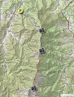
- Mile 0.0 – Park on the right side of Water Shed Rd beside a brown national forest sign listing this as a hikers only path. If this space is full refer to the alternate parking option above. Follow the gravel Water Shed Rd to begin the Black Mountain Crest Trail.
- Mile 0.1 – Old bridge or rock hop over Bowlens Creek. The bridge looks to be in poor shape so it is best to avoid it. On the other side of the creek you’ll see the national forest carsonite sign for the Black Mountain Crest Trail [179] (orange or white blazes). For the next 4 miles you will be following the forest road track up the northern flank of Celo Knob gaining nearly 3,000 feet in elevation.
- Mile 0.8 – The trail makes a hard left away from Bowlens Creek. The forest road grade moderately ascends a ridge high above Bowlens Creek. Occasionally old forest roads will branch off from the main trail. The crest trail in this section has no noticeable blazes but stick to the most defined road heading uphill.
- Mile 3.5 – At a left curve is a side path on the right to Bowlens Creek if you need a good water source.
- Mile 3.8 – A good spring on trail. There is one more spring above this, but it is tiny.
- Mile 4.0 – Last spring on trail, the origin of Bowlens Creek. This will almost always be a small trickle so it is advisable to fill up on water before this.
- Mile 4.2 – The trail leaves the forest behind entering a beautiful section on the southwest shoulder of Celo Knob. Along this open stretch you’ll have views south and west of the Black Mountains surrounding the Big Tom Wilson Preserve in the Cane River Valley plus distant views of the Great Craggy Mountains and Newfound Mountains. You can trace your future route immediately south as the trail sticks to the west side of the ridgeline.
- Mile 4.4 – At a right turn there is a side path to a campsite and the Celo Knob scramble trail at a carsonite sign. This scramble is sometimes hard to follow if you’re looking to climb this peak. There are views from two outcrops near the summit. Just beyond the scramble trail junction a forest road splits right at a Y-junction heading downhill. Turn around for a good view of Celo Knob. The crest trail is mostly flat beyond this junction as it heads towards Gibbs Mountain.
- Mile 4.7 – T-junction with the Woody Ridge Trail [177] (yellow blaze) on the left
- Mile 5.6 – A nice open spot with a rock bench looking west at the western Blacks and south at your future route. This spot is also before the road grade peters out and the crest trail becomes a narrow, rocky path.
- Mile 5.9 – Trail passes over a narrow, rocky spine along tall, eastern cliffs with views in every direction. This is your first view of Linville Gorge to the east. Looking ahead you can see the sawteeth row of peaks you will be climbing later.
- Mile 6.3 – Campsites in shaded area on the right side of the trail. Soon after this campsite is a steady climb up Winter Star Mountain.
- Mile 6.9 – On your left is a nice overlook northeast below the top of Winter Star Mountain with the Roan Highlands in the distance. This view is better than what you will have at the summit.
- Mile 7.0 – Summit of Winter Star Mountain (6,203 feet). There is a view northwest through barren trees beside the summit marker. The next half mile is a steep descent to Deep Gap with occasional views of Potato Hill and Cattail Peak.
- Mile 7.5 – T-junction with the Colbert Ridge Trail [178] (yellow blaze) on the left. You can take this trail downhill for ~0.4-mi to find an unreliable spring that is frequently cited as the best water source near Deep Gap. We recommend following the forest road west from Deep Gap noted at Mile 7.6.
-
Mile 7.6 – Beyond the Colbert
Ridge Trail the crest trail passes through Deep Gap, a large notch in
the central Black Mountains. Deep Gap is located at the top of the
Colbert Ridge Trail and is also the last place to freely camp outside
of the state park, so you’ll likely run into more hikers beyond this
point. An old forest road splits to the right just before you enter the
state park boundary. There are multiple springs down this forest road.
We are unsure of the distance but if the first spring is too low keep
going down the road to pass more springs. Beyond Deep Gap the trail is
officially designated and blazed as the Deep Gap Trail (orange triangle blaze) by the state park, but is also the Black Mountain Crest Trail.
Beyond the state park boundary is a long climb up Potato Hill. As you near the summit the trail will skirt large eastern cliffs with views southeast.
- Mile 8.5 – A very short path on the right leads to the summit of Potato Hill (6,475 feet), a subpeak of Cattail Peak. The summit is mostly forested but there is a view to the northwest. Initially the descent from Potato Hill is almost vertical in spots. You’ll have one view during this section south of Balsam Cone and then you’ll pass through a long stretch of southern Appalachian spruce-fir forest.
- Mile 9.1 – The trail passes right by a sign indicating Cattail Peak with elevation printed. This is misleading because the trail does not pass over the actual peak and skims the southwest flank. The bushwhack from the trail is easy if you are peakbagging, but there are no clear views at the summit.
- Mile 9.6 – Trail passes over the forested summit of Balsam Cone (6,611 feet) then begins descending to Big Tom Gap.
- Mile 10.0 – T-junction with the Big Tom Gap Trail junction shortly before Big Tom Gap. The Big Tom Gap Trail [191A] (blue blaze) leads very steeply down the mountain towards the Buncombe Horse Range Trail and Maple Camp Bald, providing loop alternatives for doing the crest trail both ways. There is also excellent camping at Commissary Hill and Maple Camp Bald.
- Mile 10.1 – Pass through Big Tom Gap. From here it is a steep climb to Big Tom with lots of exposed rocks.
- Mile 10.3 – Just above Big Tom Gap there are two slick sections of exposed rocks with ropes anchored for assistance. In the winter these rocks are usually covered in ice.
- Mile 10.4 – Just below Big Tom there are rock outcrops on the right with good views northwest. Reach the summit of Big Tom (6,581 feet), a subpeak of Mt. Craig. While there are no clear views the summit has one of the largest collections of ghost trees on this hike. Many of the trees around the highest elevations of Black Mountains are adversely affected by extreme winter, pests, and disease.
- Mile 10.7 – Trail passes over the exposed rock cliffs of Mt. Craig, the 2nd tallest mountain in the east at 6,647 feet. A series of logs line the trail along the cliffs. These logs are not to prevent falling from the cliffs, but to prevent you from leaving the designated trail so rare cliff species can survive. Please stay on the trail. From here you have grand views south to west to north. First look north as you can trace your route up and down the northern Blacks. Due west is the deep Cane River Valley with the western Blacks rising high above. To the south is Mt. Mitchell. The mountain looks unremarkable from here compared to all the development built around the summit.
- Mile 11.5 – Before you get to the summit parking you will pass through a nice stretch of southern Appalachian spruce-fir forest. The Black Mountain Crest Trail ends at summit parking lot. Walk to the top of the lot towards the bathrooms and gift shop to find the paved walkway to the observation tower.
- Mile 11.7 – Old Mitchell Trail splits off to the right (yellow circle blaze). This is an option for longer shuttles and for backpackers heading to the tent camping area.
-
Mile 11.8 – Reach the summit of Mt. Mitchell, the highest mountain in the east at 6,684 feet. The grave site of Dr. Elisha Mitchell is below the observation tower. The observation tower was remodeled in 2008 and provides 360° views complete with interpretive signs in each direction that help you identify all the mountains and land features in view.
Immediately north Mt. Craig is the closest peak. The northern Black Mountains dominate the skyline as they undulate for miles ending at the conical Celo Knob which you passed earlier. Farther north you can see the tall, gently sloped mountains of the Roan Highlands. In the northeast Grandfather Mountain sticks out as the tallest peak in its immediate area. Linville Gorge and the iconic Table Rock Mountain and Hawksbill Mountain are visible in the east. Due south you can spot Highway 128 curving along the southern Black Mountains, with the radio towers of Clingmans Peak rising beside Mt. Gibbes. Pinnacle is the conical peak to the left of Clingmans Peak. Graybeard Mountain is in between Pinnacle and Clingmans Peak but smaller and more rounded. The Black Mountains are shaped like a J and this is never more readily apparent than atop Mt. Mitchell where you can see the southwestern peaks curve around the Cane River Valley. Due west are the smallest of the Blacks, Point Misery and Big Butt. Towards the southwest Blackstock Knob is the highest peak with a small, rounded summit. Immediately behind and to the left is the distinctive summit of Craggy Dome, the tallest peak in the Great Craggy Mountains. Most of the Great Craggy Mountains are obscured from view by the taller Black Mountains. If you summit on a clear day, you will be able to see tall ridgelines of the Great Balsam Mountains and Great Smoky Mountains running southwest to west.
- Mile 12.1 – Hike ends at summit parking lot, if you are doing a shuttle.