The Mt. Katahdin Loop Trail at Baxter State Park near Millinocket, Maine is a strenuous 8.6-mile loop hike that summits Mount Katahdin and follows three trails, including one of the most scenic, but dangerous trails on the mountain.
This loop, to the summit of Mount Katahdin, is a very strenuous hike and on average, experienced hikers will find their speed is close to 1-mph while taking this route, hence this is a very long day hike at best. Hikers should come prepared with the proper footwear, a light jacket for the summit (or heavier jacket depending on the season), and trekking poles to help ease your hike down the mountain. Note that for an alternative route which makes the Knife Edge Trail optional, hikers may want to consider hiking up Mt. Katahdin via Hunt Trail (Appalachian Trail) instead.
Trails & Difficulty
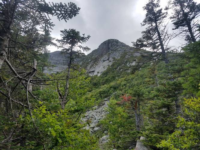
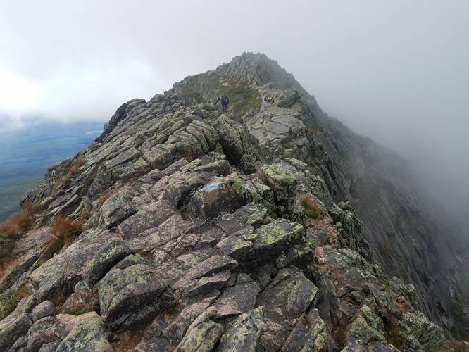
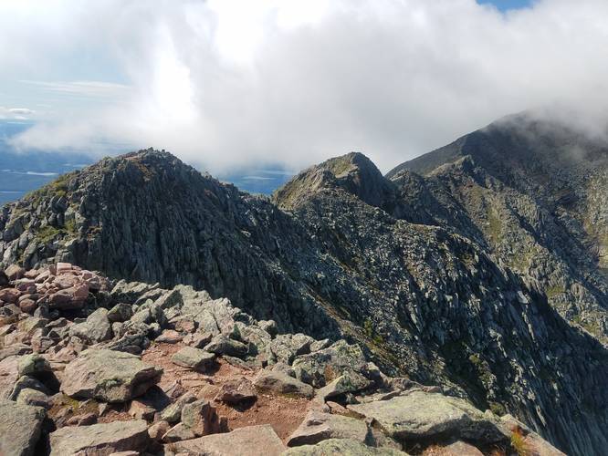
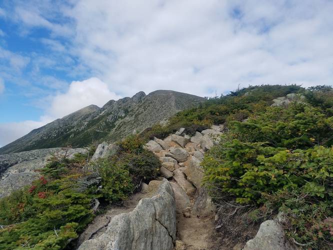
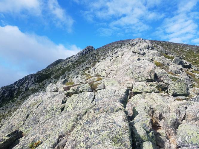
Helon Taylor Trail, Knife Edge Trail, and Cathedral Trail. This route follows the Helon Taylor Trail up, follows the Knife Edge Trail, then follows the Cathedral Trail down the mountain and back to parking. This is the harder way to hike this loop due to the steeper portion of the Cathedral Trail - heading downhill is generally worse. If you want an easier hike, take the Cathedral Trail up and the Knife Edge, Helon Taylor Trail down the mountain.
Elevations
The total elevation gain on this hike is just over 4,000-feet. This trail should be attempted by experienced hikers only.
Length & Notes
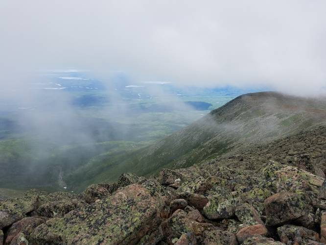
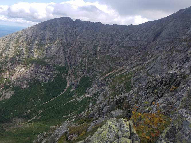
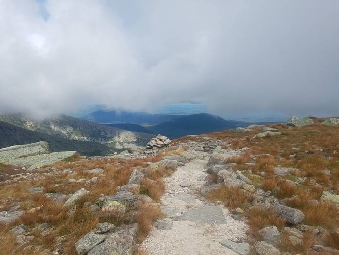
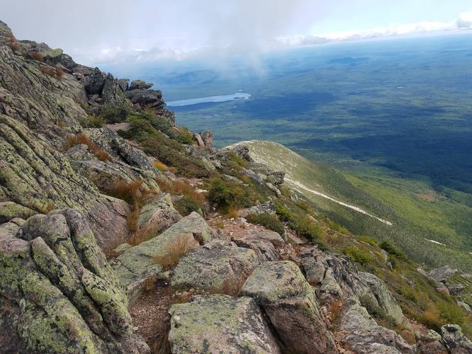
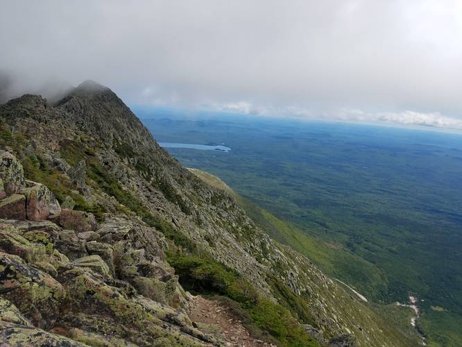
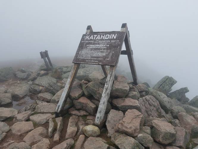
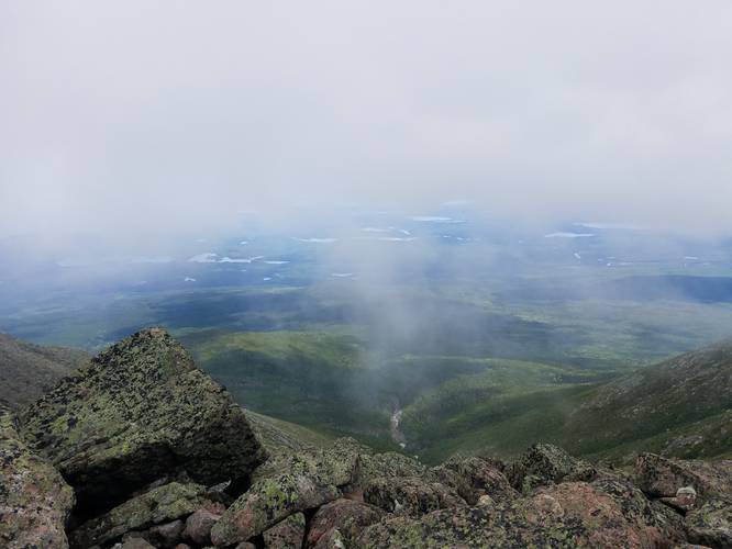
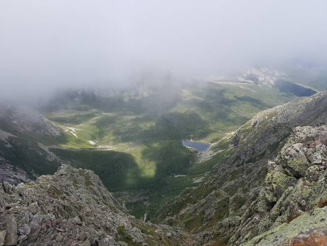
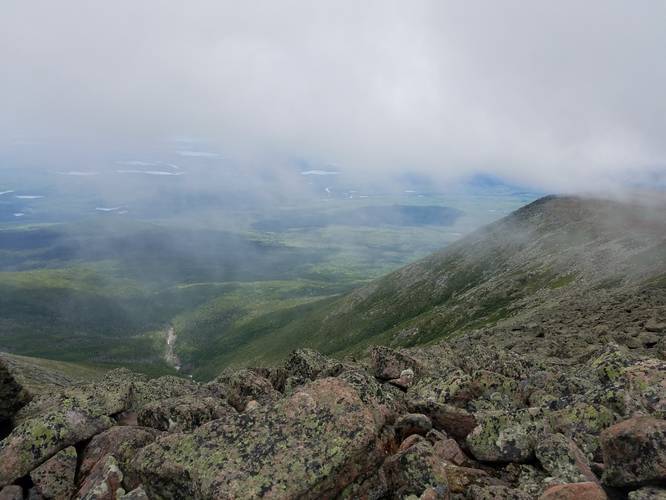
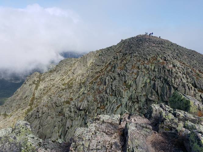
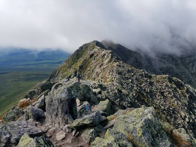
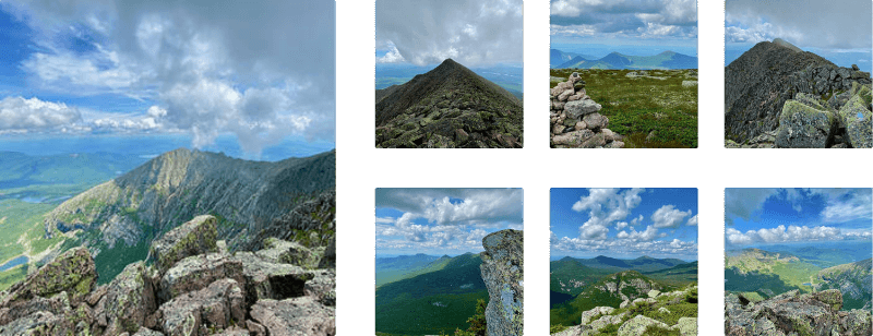
When I decided to hike to the Katahdin summit, I knew I wanted to take the Knife's Edge trail. I was up for a good amount of scrambling and the thrills of steep drop-offs on either side. However, I was not expecting this trail to take as long as it did. I came up the Helon Taylor trail and then continued on to knife's edge. This mile long section of trail took me a couple of hours to hike, and I found the process more draining than I expected. Maybe it was the lack of sleep and not-so-great breakfast I had, but I struggled with this trail. It was still a great hike and the summit was nice (although views were mostly obscured by clouds when I was up there). Initially, I was planning on hitting the summit of Hamlin before heading down the Hamlin ridge trail for an 11-mile loop, with a backup plan of taking the Saddle Trail down for a shorter trip, but as soon as we saw the first turn off the ridge for the Cathedral Trail, my hiking partner wanted to take it and head down ASAP. I would NOT recommend going down this trail. It was very steep and rocky, with a few wet slippery spots. I took it slow and completely burned out my legs climbing down the rocks. It felt like a long hike back to the car, even though it was only a 4-mile hike down from the summit.
Time to Hike
In total the hike took 9 hours. I usually hike 2mph including breaks so this hike was much slower for me. I would still absolutely recommend this gorgeous and exhilarating hike, but if you do this loop I recommend hiking up Mount Katahdin along the Cathedral Trail and down along the Knifes Edge and Helon Taylor to help your knees on the way down.
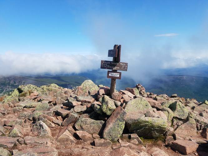
Appalachian Trail Terminus
Mt. Katahdin's summit is the northern terminus for the Appalachian Trail. Hikers may run into AT thru-hikers along this trail as many people try to work their way from the southern terminus in Georgia all the way up to Mount Katahdin.
Parking, Entrance Fees, and Permits
Hikers need a parking permit to park and hike Katahdin. To purchase a permit ($5 per day as of May 2022), you can head to this link. Additionally, there's an Out-of-State entrance fee for vehicles coming to Baxter State Park ($16/vehicle as of May 2022), which needs to be purchased as well. To purchase an out-of-state entrance pass, please visit this link. An account is required (as of May 2022 on the BSP website) to reserve a parking pass and/or out-of-state entrance pass. Upon calling the park, the rangers mentioned that reserved parking permits are invalid after 7AM if you do not show up and are then given to first-come first-serve visitors who do not have a parking permit. So if you have a reservation to hike Katahdin, show up before 7AM or else you'll lose your spot. If you do not have a parking permit to hike Katahdin, but still want to try on the day-of, the rangers mentioned folks should arrive at 5AM to claim a stake near the beginning of the waiting queue to try and grab a spot from a permit holder who does not show up by 7AM.
Pets
Dogs are NOT allowed at Baxter State Park.
This loop, to the summit of Mount Katahdin, is a very strenuous hike and on average, experienced hikers will find their speed is close to 1-mph while taking this route, hence this is a very long day hike at best. Hikers should come prepared with the proper footwear, a light jacket for the summit (or heavier jacket depending on the season), and trekking poles to help ease your hike down the mountain. Note that for an alternative route which makes the Knife Edge Trail optional, hikers may want to consider hiking up Mt. Katahdin via Hunt Trail (Appalachian Trail) instead.
Trails & Difficulty
Helon Taylor Trail, Knife Edge Trail, and Cathedral Trail. This route follows the Helon Taylor Trail up, follows the Knife Edge Trail, then follows the Cathedral Trail down the mountain and back to parking. This is the harder way to hike this loop due to the steeper portion of the Cathedral Trail - heading downhill is generally worse. If you want an easier hike, take the Cathedral Trail up and the Knife Edge, Helon Taylor Trail down the mountain.
Elevations
The total elevation gain on this hike is just over 4,000-feet. This trail should be attempted by experienced hikers only.
Length & Notes
When I decided to hike to the Katahdin summit, I knew I wanted to take the Knife's Edge trail. I was up for a good amount of scrambling and the thrills of steep drop-offs on either side. However, I was not expecting this trail to take as long as it did. I came up the Helon Taylor trail and then continued on to knife's edge. This mile long section of trail took me a couple of hours to hike, and I found the process more draining than I expected. Maybe it was the lack of sleep and not-so-great breakfast I had, but I struggled with this trail. It was still a great hike and the summit was nice (although views were mostly obscured by clouds when I was up there). Initially, I was planning on hitting the summit of Hamlin before heading down the Hamlin ridge trail for an 11-mile loop, with a backup plan of taking the Saddle Trail down for a shorter trip, but as soon as we saw the first turn off the ridge for the Cathedral Trail, my hiking partner wanted to take it and head down ASAP. I would NOT recommend going down this trail. It was very steep and rocky, with a few wet slippery spots. I took it slow and completely burned out my legs climbing down the rocks. It felt like a long hike back to the car, even though it was only a 4-mile hike down from the summit.
Time to Hike
In total the hike took 9 hours. I usually hike 2mph including breaks so this hike was much slower for me. I would still absolutely recommend this gorgeous and exhilarating hike, but if you do this loop I recommend hiking up Mount Katahdin along the Cathedral Trail and down along the Knifes Edge and Helon Taylor to help your knees on the way down.
Appalachian Trail Terminus
Mt. Katahdin's summit is the northern terminus for the Appalachian Trail. Hikers may run into AT thru-hikers along this trail as many people try to work their way from the southern terminus in Georgia all the way up to Mount Katahdin.
Parking, Entrance Fees, and Permits
Hikers need a parking permit to park and hike Katahdin. To purchase a permit ($5 per day as of May 2022), you can head to this link. Additionally, there's an Out-of-State entrance fee for vehicles coming to Baxter State Park ($16/vehicle as of May 2022), which needs to be purchased as well. To purchase an out-of-state entrance pass, please visit this link. An account is required (as of May 2022 on the BSP website) to reserve a parking pass and/or out-of-state entrance pass. Upon calling the park, the rangers mentioned that reserved parking permits are invalid after 7AM if you do not show up and are then given to first-come first-serve visitors who do not have a parking permit. So if you have a reservation to hike Katahdin, show up before 7AM or else you'll lose your spot. If you do not have a parking permit to hike Katahdin, but still want to try on the day-of, the rangers mentioned folks should arrive at 5AM to claim a stake near the beginning of the waiting queue to try and grab a spot from a permit holder who does not show up by 7AM.
Pets
Dogs are NOT allowed at Baxter State Park.