Mt. Katahdin via Hunt Trail (AT/Appalachian Trail) at Baxter State Park near Millinocket, Maine is a strenuous 9.9-mile out-and-back hike that leads to the highest summit of Katahdin, Baxter Peak and also features a stop at Katahdin Stream Falls, a short hike along the glacial arête of the breathtaking Knife Edge Trail, and stunning views into Katahdin's bowl (South Basin / Great Basin).
Trails
This hike follows several named trails: Hunt Trail (AT/Appalachian Trail), white blazes; Saddle Trail; Knife Edge, blue blazes.
Hike Description
This hike begins at the Katahdin Stream Campground parking area and follows the Hunt Trail up the mountain, which is also the same path as the Appalachian Trail. The trail first passes through a section of the Katahdin Stream Campground before reaching a privy and trail registration station, around mile 0.15. After mile 0.15, the trail slowly meanders its way up the mountain as its substrate turns from an easy-to-follow path to a more rock-filled path with rocks for steps as it approaches the Owl Trail.
Owl Trail Junction - Mile 1
Around mile 1, hikers will pass a trail junction with the Owl Trail. Just beyond here is where the hike becomes a bit more interesting as Katahdin Stream Falls approaches.
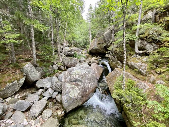
Katahdin Stream Crossing - Mile 1.1
Around mile 1.1, hikers will reach a wooden bridge that crosses the crystal-clear waters of Katahdin Stream. There are some small waterfalls that tumble their way downstream, which I've labeled as "Lower Katahdin Stream Falls" in the POI. This is a nice break before the trail becomes much more difficult right after this stream crossing as it begins to follow a much steeper grade. Just uphill from this stream crossing is the ~50-foot Katahdin Stream Falls.
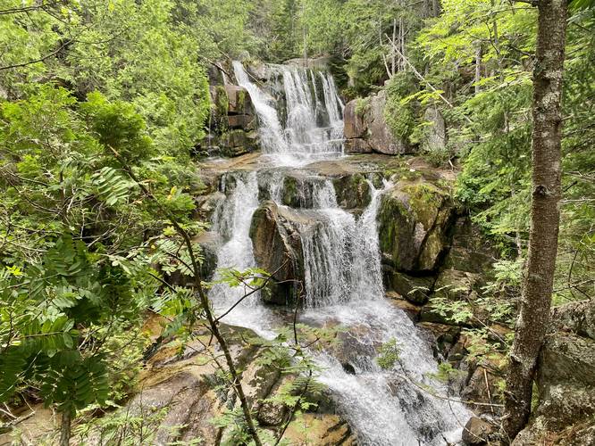
Katahdin Stream Falls, 50-foot cascade - Mile 1.17
At mile 1.17, hikers will reach the large multi-tiered cascade, Katahdin Stream Falls, which spills down Mt. Katahdin at approximately 50-feet if you include all three cascades. Each cascade of the waterfall is about 15 to 20-feet tall, with some varying height in between. To get the best view of Katahdin Stream Falls, there's a small spur trail that leads down to a rocky ledge that provides a full view of the waterfall; however, there are some spots you can sit down and hang out above the main cascades - where even more, smaller, waterfalls can be found upstream. These additional waterfalls are no taller than about 8-feet tall.
Mountain Hiking and Filterable Water - Mile 1.17 to 1.9
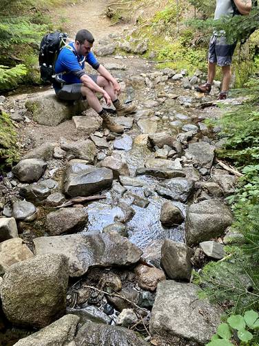
After passing Katahdin Stream Falls, hikers will be back at it cruising up Mt. Katahdin along a steep grade as it follows rocky steps, and some boulder scrambles, as it gets closer to the alpine zone. There are even massive boulders, the size of small homes, that jut out over the trail that you'll walk under. Taking breaks along this section of the hike is key to save up energy for The Gateway scrambling and light non-technical climbing ahead. Note that during our hike in August 2022, around mile 1.9, was a small stream that spilled down the mountain - hikers can use this to filter more water.
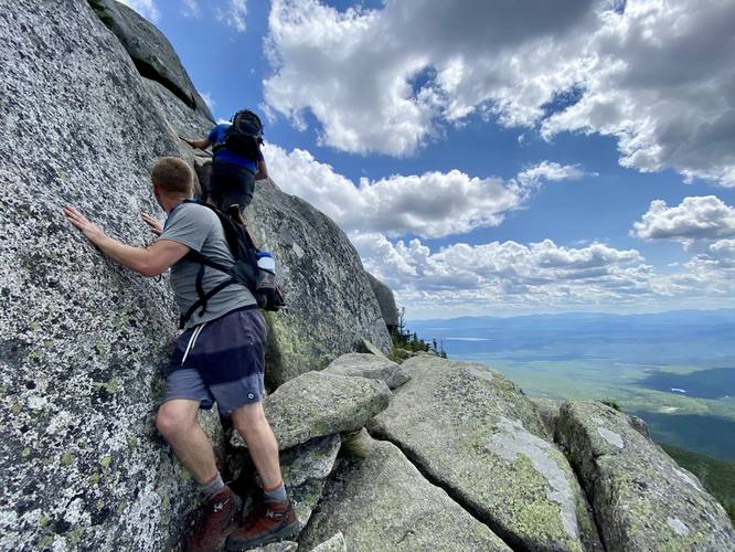
The Gateway, Rock Scrambles, and Non-technical Climbing - Mile 2.6 to 3.2
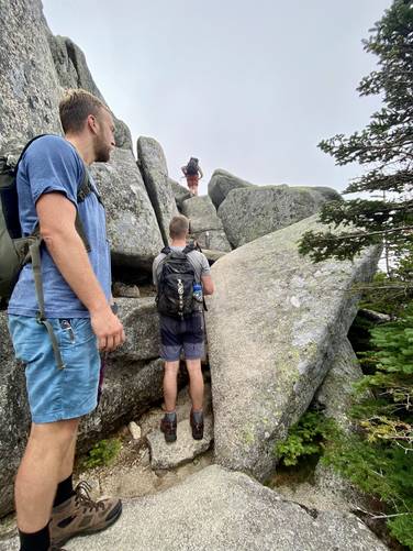
Once hikers reach mile 2.6, the hike turns into a light non-technical climb with a crazy-amount of rock scrambling along the way, named The Gateway. Right off the bat, the trail will follow a rock scramble that's ~50 vertical feet tall and is separated into smaller sections. The first section is a small series of rock scrambles up a 15-foot grade, next a 10-foot climb with a pull-up bar at the top of the rock - use your feet to cling onto rocks placed within the crack below the pull-up bar. Just beyond the pull-up bar section is a sketchy downward slope rock scramble for about 8-feet with a steep and sketchy adjacent plunge. Just beyond that are two sections of rock scrambling that include metal hand and foot holds to keep you from falling down the (at this point) 30+ foot vertical fall. At the top of this first section of climbing, the rock scrambling becomes far-less sketchy, but requires a lot of navigating, pulling yourself up rocks, find foot and hand holds in the bedrock, in addition to scraping your hands and body along the bumpy granite. The Gateway has some easy walking between miles 2.8 to 2.9 where the trail is slightly less steep and there are no boulders. Do not get too comfortable, however, because The Gateway gets even worse between mile 2.9 and 3.2 where the scrambling is even harder than the initial section because it's steeper. Taking multiple breaks in The Gateway is very common. Note that it's difficult following the trail within The Gateway and thus your hike in this section may not follow the exact trail as you navigate the scrambles. Head uphill whichever way you find easiest and do not follow the blazes if they lead to a precarious place.
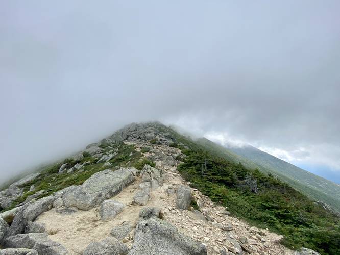
Hunts Peak, Katahdin Tableland, and the Thoreau Spring - Mile 3.2 to 3.7
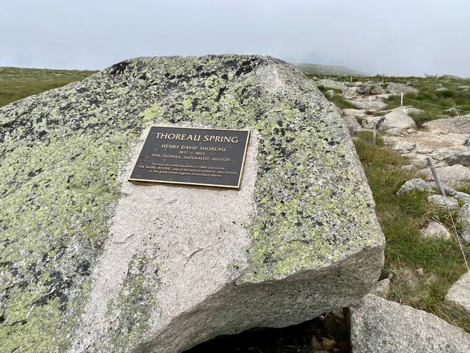
Hikers will reach the top of The Gateway, where they're spit out onto Katahdin's plateau named the Tableland, around mile 3.2. Katahdin's tableland is comprised of rare plant species like the Diapensia and Mountain Cranberry - some of which can die after just three steps. It's best to always stay on-trail unless you rock-hop to a location off-trail. Do not go off-trail in the designated regrowth areas. Once on Katahdin's tableland, the hike is significantly easier (for now). At mile 3.7, hikers will reach the Thoreau Spring which is a natural spring on Mount Katahdin that's located at the junction with the Abol Trail. This natural spring was named after Henry David Thoreau, who climbed Katahdin in 1846 before writing the "The Maine Woods". It appears as though the Thoreau Spring originates or drains below the rock with the named plaque, but that's speculation. Despite being a natural spring, the water appears to sit on the trail, moving extremely slowly, so if you plan to drink water from the Thoreau Spring, it must be treated first.
Tableland to Baxter Peak - Mile 3.7 to 4.7
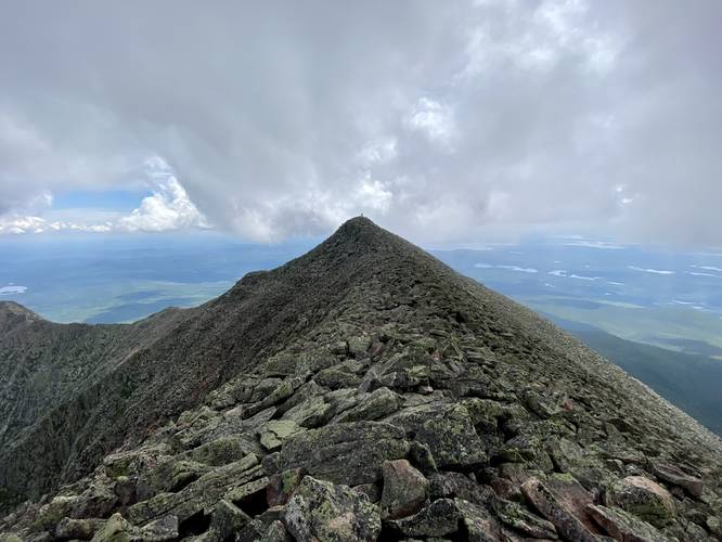
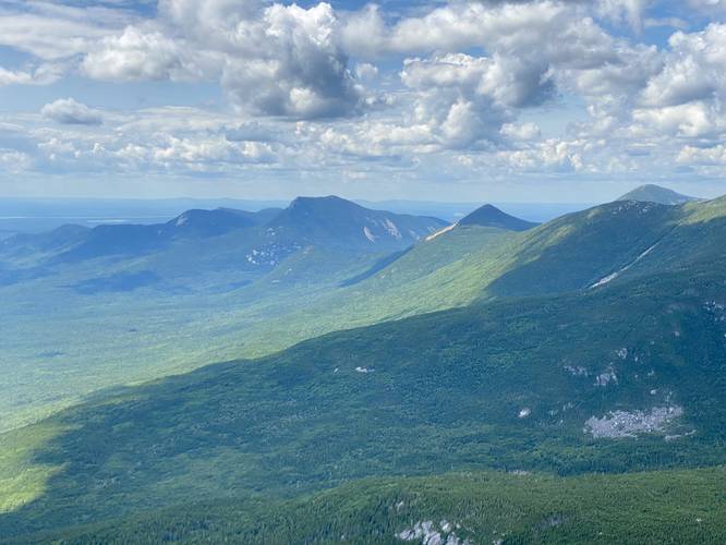
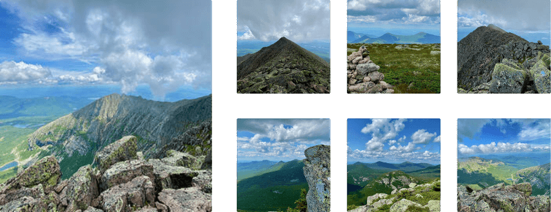
After passing the Abol Trail junction and the Thoreau Spring, hikers will follow Katahdin's tableland for approximately 0.4-miles longer. Enjoy the flatter section of the mountain, and take in some easterly views of Baxter Peak and South Peak, before making the final ascent to Baxter Peak. This last stretch to reach Baxter Peak starts around mile 3.7 and while it's not as difficult as any of the elevation grade along the rest of the trail, it's not an easy ascent. Take your time and enjoy the views of Baxter Peak and South Peak - located along the Knife Edge Trail - if the cloud cover allows, because it's a spectacular sight seeing hikers traverse the glacial arête of the Knife Edge as the clouds pour over the mountain's ridge.
Baxter Peak, Bowl Views, and Knife Edge Trail - Mile 4.7 to 5
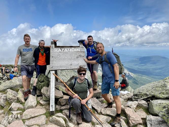
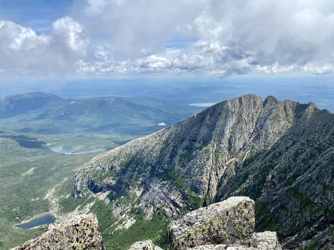
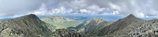
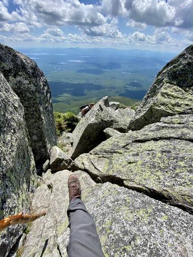
Victory! Finally, you'll reach Baxter Peak with it's Katahdin and Appalachian Trail northern terminus sign around mile 4.7. The feeling of reaching Baxter Peak, Katahdin's highest summit, is like no other hike in the northeast United States, as this hike requires cooperation from all muscles in your body to reach the top. The view from Baxter Peak is stunning as well; however, most people will reach the summit with plenty of other hikers around. Upon our hike here, we decided to take a nice break off-trail, rock hopping over to a steep cliff above Katahdin's "bowl", formerly known as South Basin with Great Basin located due north. This spot provided stunning, and also scary views into the bowl. We even had a birds-eye-view of a mountain climber in South Basin slowly making is own ascent up a technical climbing route on the mountain. After taking a break, we decided to explore the Knife Edge Trail. The Knife Edge Trail is comprised of boulders that hikers must traverse in a very slow and careful fashion. The trail follows loosely-defined blue blazes; however, whichever way you walk is usually fine if not directly off of a 3,000-foot cliff. We followed the glacial arête of the Knife Edge Trail out to a small peak between Baxter Peak and South Peak labeled "Mount Katahdin" on some maps. From this view, we had a 360-degree view along the insanely-steep Knife Edge, took some photos - including panoramas - and then went back to the crew waiting just north of Baxter Peak at our bowl view spot.
Notes for Hiking Out - Mile 5 to 9.9
Obviously the hike in follows the same trail out - Hunt Trail / AT. This may seem daunting at first - traversing The Gateway boulder scrambles heading downhill; however, we found that the hike downhill was easier than anticipated - mostly because you can see which route is easier on the way down. On the way up, it's much harder to guess which scramble is easier. It's best to always toss your trekking poles or backpack down the scrambles where they may cause you to fall over or lose your footing, take your time, and go slow. Always use the metal hand and foot holds to help aid in going down some of these steeper scrambles. Aside from the The Gateway downhill scrambles, the hike out can be mentally-taxing as you traverse countless rocks and other obstacles in the trail for what feels like forever. A nice stop along the way down, despite being close to the trailhead, is Katahdin Stream Falls - we stopped here just above the main cascades on our hike down to enjoy one last scenic part of Katahdin before our trip ended. It's also a nice place to cool-off in the stream.
End of the Appalachian Trail (AT)
The Hunt Trail also shares the same path as the Appalachian Trail, which ends at the top of Katahdin's tallest peak - Baxter Peak. Upon my hike here, our group passed many different folks who were either completing the AT thru-hike or were completing the last leg of section-hiking the entire trail. This led to some vastly-different personalities on the trail - those who wanted others to know they were wrapping up their journey and those who were quiet as mice and kept to themselves.
Parking, Fees, and Reservations (Important)
In order to guarantee a hike on Mount Katahdin, hikers first must reserve a parking space through Baxter State Park's online system. Please find their reservation system on their main website at baxterstatepark.org. Maine residents are allowed to book parking reservations approximately 3-months in advance, while out-of-state hikers can only book up to 2-weeks ahead of their scheduled hike. This online reservation system, for out-of-state hikers, can be a huge pain, as you will need to log on at exactly midnight 2-weeks in advance to try and claim a parking space. Parking reservations are kept until 7AM and then are freed, if not checked-in, to allow first-come first-serve hikers to park at one of the three main parking lots. Baxter State Park does not open their main entrance gate until 6AM each day; however, it's a smart idea to show up as early as possible to ensure you get into the park without forfeiting your parking reservation at 7AM. Additionally, Baxter State Park requires fees - as of August 2022, the park entry fee was $16/vehicle and the parking reservation was $5/vehicle. Be smart and print out your parking and gate entry pass before arriving at the gate.
Cut-off Times and Time to Hike
This trail takes about 9-hours to hike for the average hiker. As of August 2022, this trailhead had several cut-off hiking times listed for Mount Katahdin. The times are as follows... August: 11AM, September: 10AM, October: 9AM.
Warnings (Death Rating)
Rock scrambles, light non-technical climbing: This trail requires work from all muscles in your body in the form of rock scrambling and very-light non-technical climbing. What I mean by non-technical climbing is things like: pulling yourself up rock scrambles, finding hand and foot holds to aid in these scrambles, shifting your body-weight while traversing sketchy and steep granite bedrock, all while scraping up your hands - this to me, is non-technical climbing. This is not for everyone and may seem daunting at first; however, this was my first time engaging in full-body non-technical climbing and, while going very slowly, everything turned out fine. That's not the case for everyone, however.
Steep elevation: This hike follows some very steep elevation grades. It's best to bring trekking poles to help in both the ascent and descent. They will help take some pressure off of your knees and may give you some additional balance.
Water: There are some places to filter water along this trail; however, Katahdin Stream is the last reliable source of water. It's best for each hiker to bring at least 2 liters of water to ensure they have enough for the entire trek.
Lack of cell service: With Verizon, the only place on the mountain that I had any cell service was in the middle of The Gateway. Other than that, I had no cell service at all and this is likely the case for other cell service providers. Any injury on the trail that might need immediate attention may be hindered by the lack of cell service.
Restrooms: There are two privies on this trail - one located near mile 0.15 and one located near the Katahdin Stream crossing around mile 1.15. After that, there are no restroom facilities. Hikers who must relieve themselves should go off-trail. If you can, always bury waste and toilet paper. For this reason, it's advised to not eat any blueberries growing on bushes in the alpine zone.
Weather Conditions / Deaths: Wind, rain, snow, and ice are all problems that hikers may face on Mt. Katahdin. Summer is by far the most calm season to climb the mountain; however, hikers may still face cold temperatures and rain during the Summer too. It's best to come prepared and pack layers - a wind-breaking jacket, a sweatshirt, hiking pants, extra socks, headlamp with batteries, and even a down winter jacket are all recommended during Summer ascents. During the Spring and Fall, hikers will likely need to bring hiking crampons, a winter jacket, winter hat, hand warmers, winter gloves, and an emergency blanket to name a few items. If planning a winter ascent, it's best to have winter mountaineering experience with the proper gear including waterproof clothing, ice axe, avalanche training, and more. Note that the wind on Katahdin can be extreme - in some cases, hikers have been blown off the Knife Edge to fall to their deaths. Always be on the lookout for a weather window to hike and if the weather does not appear to be safe at any time, it's best to turn back.
Trails
This hike follows several named trails: Hunt Trail (AT/Appalachian Trail), white blazes; Saddle Trail; Knife Edge, blue blazes.
Hike Description
This hike begins at the Katahdin Stream Campground parking area and follows the Hunt Trail up the mountain, which is also the same path as the Appalachian Trail. The trail first passes through a section of the Katahdin Stream Campground before reaching a privy and trail registration station, around mile 0.15. After mile 0.15, the trail slowly meanders its way up the mountain as its substrate turns from an easy-to-follow path to a more rock-filled path with rocks for steps as it approaches the Owl Trail.
Owl Trail Junction - Mile 1
Around mile 1, hikers will pass a trail junction with the Owl Trail. Just beyond here is where the hike becomes a bit more interesting as Katahdin Stream Falls approaches.
Katahdin Stream Crossing - Mile 1.1
Around mile 1.1, hikers will reach a wooden bridge that crosses the crystal-clear waters of Katahdin Stream. There are some small waterfalls that tumble their way downstream, which I've labeled as "Lower Katahdin Stream Falls" in the POI. This is a nice break before the trail becomes much more difficult right after this stream crossing as it begins to follow a much steeper grade. Just uphill from this stream crossing is the ~50-foot Katahdin Stream Falls.
Katahdin Stream Falls, 50-foot cascade - Mile 1.17
At mile 1.17, hikers will reach the large multi-tiered cascade, Katahdin Stream Falls, which spills down Mt. Katahdin at approximately 50-feet if you include all three cascades. Each cascade of the waterfall is about 15 to 20-feet tall, with some varying height in between. To get the best view of Katahdin Stream Falls, there's a small spur trail that leads down to a rocky ledge that provides a full view of the waterfall; however, there are some spots you can sit down and hang out above the main cascades - where even more, smaller, waterfalls can be found upstream. These additional waterfalls are no taller than about 8-feet tall.
Mountain Hiking and Filterable Water - Mile 1.17 to 1.9
After passing Katahdin Stream Falls, hikers will be back at it cruising up Mt. Katahdin along a steep grade as it follows rocky steps, and some boulder scrambles, as it gets closer to the alpine zone. There are even massive boulders, the size of small homes, that jut out over the trail that you'll walk under. Taking breaks along this section of the hike is key to save up energy for The Gateway scrambling and light non-technical climbing ahead. Note that during our hike in August 2022, around mile 1.9, was a small stream that spilled down the mountain - hikers can use this to filter more water.
The Gateway, Rock Scrambles, and Non-technical Climbing - Mile 2.6 to 3.2
Once hikers reach mile 2.6, the hike turns into a light non-technical climb with a crazy-amount of rock scrambling along the way, named The Gateway. Right off the bat, the trail will follow a rock scramble that's ~50 vertical feet tall and is separated into smaller sections. The first section is a small series of rock scrambles up a 15-foot grade, next a 10-foot climb with a pull-up bar at the top of the rock - use your feet to cling onto rocks placed within the crack below the pull-up bar. Just beyond the pull-up bar section is a sketchy downward slope rock scramble for about 8-feet with a steep and sketchy adjacent plunge. Just beyond that are two sections of rock scrambling that include metal hand and foot holds to keep you from falling down the (at this point) 30+ foot vertical fall. At the top of this first section of climbing, the rock scrambling becomes far-less sketchy, but requires a lot of navigating, pulling yourself up rocks, find foot and hand holds in the bedrock, in addition to scraping your hands and body along the bumpy granite. The Gateway has some easy walking between miles 2.8 to 2.9 where the trail is slightly less steep and there are no boulders. Do not get too comfortable, however, because The Gateway gets even worse between mile 2.9 and 3.2 where the scrambling is even harder than the initial section because it's steeper. Taking multiple breaks in The Gateway is very common. Note that it's difficult following the trail within The Gateway and thus your hike in this section may not follow the exact trail as you navigate the scrambles. Head uphill whichever way you find easiest and do not follow the blazes if they lead to a precarious place.
Hunts Peak, Katahdin Tableland, and the Thoreau Spring - Mile 3.2 to 3.7
Hikers will reach the top of The Gateway, where they're spit out onto Katahdin's plateau named the Tableland, around mile 3.2. Katahdin's tableland is comprised of rare plant species like the Diapensia and Mountain Cranberry - some of which can die after just three steps. It's best to always stay on-trail unless you rock-hop to a location off-trail. Do not go off-trail in the designated regrowth areas. Once on Katahdin's tableland, the hike is significantly easier (for now). At mile 3.7, hikers will reach the Thoreau Spring which is a natural spring on Mount Katahdin that's located at the junction with the Abol Trail. This natural spring was named after Henry David Thoreau, who climbed Katahdin in 1846 before writing the "The Maine Woods". It appears as though the Thoreau Spring originates or drains below the rock with the named plaque, but that's speculation. Despite being a natural spring, the water appears to sit on the trail, moving extremely slowly, so if you plan to drink water from the Thoreau Spring, it must be treated first.
Tableland to Baxter Peak - Mile 3.7 to 4.7
After passing the Abol Trail junction and the Thoreau Spring, hikers will follow Katahdin's tableland for approximately 0.4-miles longer. Enjoy the flatter section of the mountain, and take in some easterly views of Baxter Peak and South Peak, before making the final ascent to Baxter Peak. This last stretch to reach Baxter Peak starts around mile 3.7 and while it's not as difficult as any of the elevation grade along the rest of the trail, it's not an easy ascent. Take your time and enjoy the views of Baxter Peak and South Peak - located along the Knife Edge Trail - if the cloud cover allows, because it's a spectacular sight seeing hikers traverse the glacial arête of the Knife Edge as the clouds pour over the mountain's ridge.
Baxter Peak, Bowl Views, and Knife Edge Trail - Mile 4.7 to 5
Victory! Finally, you'll reach Baxter Peak with it's Katahdin and Appalachian Trail northern terminus sign around mile 4.7. The feeling of reaching Baxter Peak, Katahdin's highest summit, is like no other hike in the northeast United States, as this hike requires cooperation from all muscles in your body to reach the top. The view from Baxter Peak is stunning as well; however, most people will reach the summit with plenty of other hikers around. Upon our hike here, we decided to take a nice break off-trail, rock hopping over to a steep cliff above Katahdin's "bowl", formerly known as South Basin with Great Basin located due north. This spot provided stunning, and also scary views into the bowl. We even had a birds-eye-view of a mountain climber in South Basin slowly making is own ascent up a technical climbing route on the mountain. After taking a break, we decided to explore the Knife Edge Trail. The Knife Edge Trail is comprised of boulders that hikers must traverse in a very slow and careful fashion. The trail follows loosely-defined blue blazes; however, whichever way you walk is usually fine if not directly off of a 3,000-foot cliff. We followed the glacial arête of the Knife Edge Trail out to a small peak between Baxter Peak and South Peak labeled "Mount Katahdin" on some maps. From this view, we had a 360-degree view along the insanely-steep Knife Edge, took some photos - including panoramas - and then went back to the crew waiting just north of Baxter Peak at our bowl view spot.
Notes for Hiking Out - Mile 5 to 9.9
Obviously the hike in follows the same trail out - Hunt Trail / AT. This may seem daunting at first - traversing The Gateway boulder scrambles heading downhill; however, we found that the hike downhill was easier than anticipated - mostly because you can see which route is easier on the way down. On the way up, it's much harder to guess which scramble is easier. It's best to always toss your trekking poles or backpack down the scrambles where they may cause you to fall over or lose your footing, take your time, and go slow. Always use the metal hand and foot holds to help aid in going down some of these steeper scrambles. Aside from the The Gateway downhill scrambles, the hike out can be mentally-taxing as you traverse countless rocks and other obstacles in the trail for what feels like forever. A nice stop along the way down, despite being close to the trailhead, is Katahdin Stream Falls - we stopped here just above the main cascades on our hike down to enjoy one last scenic part of Katahdin before our trip ended. It's also a nice place to cool-off in the stream.
End of the Appalachian Trail (AT)
The Hunt Trail also shares the same path as the Appalachian Trail, which ends at the top of Katahdin's tallest peak - Baxter Peak. Upon my hike here, our group passed many different folks who were either completing the AT thru-hike or were completing the last leg of section-hiking the entire trail. This led to some vastly-different personalities on the trail - those who wanted others to know they were wrapping up their journey and those who were quiet as mice and kept to themselves.
Parking, Fees, and Reservations (Important)
In order to guarantee a hike on Mount Katahdin, hikers first must reserve a parking space through Baxter State Park's online system. Please find their reservation system on their main website at baxterstatepark.org. Maine residents are allowed to book parking reservations approximately 3-months in advance, while out-of-state hikers can only book up to 2-weeks ahead of their scheduled hike. This online reservation system, for out-of-state hikers, can be a huge pain, as you will need to log on at exactly midnight 2-weeks in advance to try and claim a parking space. Parking reservations are kept until 7AM and then are freed, if not checked-in, to allow first-come first-serve hikers to park at one of the three main parking lots. Baxter State Park does not open their main entrance gate until 6AM each day; however, it's a smart idea to show up as early as possible to ensure you get into the park without forfeiting your parking reservation at 7AM. Additionally, Baxter State Park requires fees - as of August 2022, the park entry fee was $16/vehicle and the parking reservation was $5/vehicle. Be smart and print out your parking and gate entry pass before arriving at the gate.
Cut-off Times and Time to Hike
This trail takes about 9-hours to hike for the average hiker. As of August 2022, this trailhead had several cut-off hiking times listed for Mount Katahdin. The times are as follows... August: 11AM, September: 10AM, October: 9AM.
Warnings (Death Rating)
Rock scrambles, light non-technical climbing: This trail requires work from all muscles in your body in the form of rock scrambling and very-light non-technical climbing. What I mean by non-technical climbing is things like: pulling yourself up rock scrambles, finding hand and foot holds to aid in these scrambles, shifting your body-weight while traversing sketchy and steep granite bedrock, all while scraping up your hands - this to me, is non-technical climbing. This is not for everyone and may seem daunting at first; however, this was my first time engaging in full-body non-technical climbing and, while going very slowly, everything turned out fine. That's not the case for everyone, however.
Steep elevation: This hike follows some very steep elevation grades. It's best to bring trekking poles to help in both the ascent and descent. They will help take some pressure off of your knees and may give you some additional balance.
Water: There are some places to filter water along this trail; however, Katahdin Stream is the last reliable source of water. It's best for each hiker to bring at least 2 liters of water to ensure they have enough for the entire trek.
Lack of cell service: With Verizon, the only place on the mountain that I had any cell service was in the middle of The Gateway. Other than that, I had no cell service at all and this is likely the case for other cell service providers. Any injury on the trail that might need immediate attention may be hindered by the lack of cell service.
Restrooms: There are two privies on this trail - one located near mile 0.15 and one located near the Katahdin Stream crossing around mile 1.15. After that, there are no restroom facilities. Hikers who must relieve themselves should go off-trail. If you can, always bury waste and toilet paper. For this reason, it's advised to not eat any blueberries growing on bushes in the alpine zone.
Weather Conditions / Deaths: Wind, rain, snow, and ice are all problems that hikers may face on Mt. Katahdin. Summer is by far the most calm season to climb the mountain; however, hikers may still face cold temperatures and rain during the Summer too. It's best to come prepared and pack layers - a wind-breaking jacket, a sweatshirt, hiking pants, extra socks, headlamp with batteries, and even a down winter jacket are all recommended during Summer ascents. During the Spring and Fall, hikers will likely need to bring hiking crampons, a winter jacket, winter hat, hand warmers, winter gloves, and an emergency blanket to name a few items. If planning a winter ascent, it's best to have winter mountaineering experience with the proper gear including waterproof clothing, ice axe, avalanche training, and more. Note that the wind on Katahdin can be extreme - in some cases, hikers have been blown off the Knife Edge to fall to their deaths. Always be on the lookout for a weather window to hike and if the weather does not appear to be safe at any time, it's best to turn back.