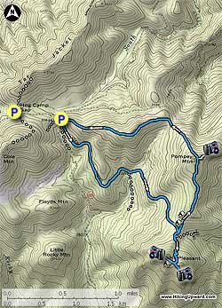
At the parking area there are three trail heads. The two Henry Lanum Memorial trails pass through wooden horse gates. Take the right Henry Lanum Memorial Trail. You will return down the left one. Once passing through the gate the blue blazed trail is mostly flat for the first 1.1 miles. Make sure to follow the blue blazes at 1.1 miles as the trail turns off the old FS road to the right, then in 0.1 miles arrives at a trail junction.
Turn left uphill following the sign and blue blazed trail. This is the steepest section of the trail where it traverses up the mountain arriving at the ridge in 1.0 miles, and intersection of the Mount Pleasant Summit Trail. Stay straight on the blue blazed Mount Pleasant Summit Trail, and in 40 yards pass a trail marked 'Water' on the left that heads downhill to a seasonal spring. Continue on the Mount Pleasant Summit Trail as it winds its way up the mountain.
In 0.3 miles be alert to follow the trail back to the left, the old summit trail continues straight. In another 0.2 miles arrive at the saddle between the two peaks. Make sure to visit them both!
The westerly summit, turning right at the saddle, has two small campsites, the second just before the overlook. Keep in mind that because of its geology the Mount Pleasant summit can experience strong winds. Also, to reach the overlook at the westerly summit you have to scramble 7 feet up through a rock scree.
Return back down from the summit to the Henry Lanum Memorial Trail intersection. Turn right, along the ridge towards Pompey Mountain. There are two large campsites within the first 0.1 miles. In 0.8 miles, and at the high point of Pompey Mountain, take the unmarked trail to the right for 75 yards to a rock outcrop and views to the northeast.
Return to the Henry Lanum Memorial Trail, turn right, and now head downhill for 0.5 miles before the trail heads to the left along the ridge for another 0.4 miles, then descends the remaining 0.7 miles back to the parking area.