Loading...

๐ŸŽ‰ Enjoy a Free 7-Day Supporter Trial and Unlock Exclusive Perks โ€” No Credit Card Required. Learn more.

Motts Run Reservoir Hike

Directions
Map
Pictures
Send to App
Distance:
4.7 Miles / 7.6 km
Type:
Out-and-Back
Difficulty:
Easy
Time to Hike:
2 hours, ~21 minutes
Features:
Surface Type:
Dirt
Town:
Fredericksburg, Virginia
Directions:
38.316548, -77.557477
Added:
April 03, 2025
Updated:
April 06, 2025
Copy Trail Link Hiking this trail? Send a friend or family member a link to this trail guide for your own safety. Hike at your own risk (disclaimer)
Loading...
Loading...
111'

Total Change
801'

Ascent
805'

Descent

Download the Trail Route for Offline Use

Supporters get exclusive access to download trail routes to the MyHikes app for offline use. Stay prepared on your adventure, even without an internet connection! Become a Supporter today to unlock this feature and hike with confidence.

Send to App

Motts Run Reservoir Hike

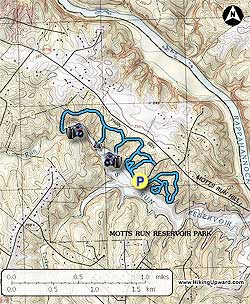
Motts Run Reservoir is an 860 acre natural area in Fredericksburg VA with a 160 acre lake. There are about 5 miles of trails with most of the trails being near or within viewable distance of the lake.

For those who live close to Fredericksburg, this would be a great little hike if you don't have enough time to head to the mountains. The highlight of the trail is the Mine Run, a creek at the end of the Mine Run Trail, be sure to visit the creek and soak your feet in it during warmer weather.

We hiked the trails to the North West of the parking lot first and then the trails to the South East.

  • Mile 0.0 โ€“ From parking area head towards Nature Center on gravel road, pass Nature Center and come to first trail sign.
  • Mile 0.1 โ€“ Turkey Ridge Trail (yellow blazed) intersection, stay straight, do not go right. Continue past 2 intersections of the Possum Path and reach the Mine Run Trail (red blazed).
  • Mile 0.3 โ€“ Mine Run Trail, bear left reaching the Lakeview Trail (green blazed) in 0.3 miles.
  • Mile 0.6 โ€“ Lakeview Trail, bear left for a 0.4 mile out and back for a nice view of the lake. Doing this and the Laurel Trail will give you a good workout down to the lake and back. Return to Mine Run Trail and bear left.
  • Mile 1.2 โ€“ Laurel Trail (purple blazed), 0.2 mile out and back to the lake. Return to Mine Run Trail and bear left. Continue on Mine Run Trail until it ends at Mine Run.
  • Mile 2.1 โ€“ Mine Run, eat a snack and soak your feet in the creek if you have time. Retrace your steps on the Mine Run Trail until the Turkey Ridge Trail.
  • Mile 3.2 โ€“ Turkey Ridge Trail intersection, stay straight, do not go right. By-pass next intersection, spur trail to park road.
  • Mile 3.3 โ€“ Spur Trail to park road, stay straight on trail and reach intial intersection of Turkey Ridge Trail.
  • Mile 3.5 โ€“ Bear left at intersection and go past Nature Center back to parking lot for Part 2 of the hike
  • Mile 3.6 โ€“ Parking Lot and beginning of Part 2 of the hike. Head South East from the Parking Lot to the Hidden Creek Trail (blue blazed) near Picnic Site 4, very quickly bear to the left and head away from the lake.
  • Mile 3.7 โ€“ Stay left at Intersection
  • Mile 3.8 โ€“ Stay left at Intersection continuing up the Hidden Creek Trail, you will come back on the Hidden Creek Trail that is on the right here. We did not hike the Old Silo Trail that should be on your left in the next 0.1-0.2 miles, it is an out and back.
  • Mile 4.1 โ€“ At next Intersection, โ€œShortcutโ€, stay straight heading down to the lake.
  • Mile 4.3 โ€“ Reach view of lake then continue up hill towards the Osprey Point Trail.
  • Mile 4.5 โ€“ Reach Osprey Point Trail (white blazed) Intersection, bear left back down to lake and nice bench overlooking lake, enjoy!
  • Mile 4.6 โ€“ Bench at lake, continue on loop back to the Hidden Creek Trail
  • Mile 4.7 โ€“ At Intersection Bear left onto the Hidden Creek Trail
  • Mile 4.8 โ€“ Bear left onto the Hidden Creek Trail
  • Mile 4.9 โ€“ Bear left onto un-named trail following the lake to head back to Parking Lot.
  • Mile 5.0 โ€“ Arrive at the parking area.
Explore 2 trails near Fredericksburg, VA
  1. Parking

    38.316548, -77.557477
  2. Main Trailhead

    38.316643, -77.557511
No community routes found. To add your own hike as a Community Route for this Trail guide, leave a Trip Report with an attached GPX file.

Hazards

Ticks - Lyme Disease More Info (CDC)
Snakes
Poison Ivy/Oak

Seasons

All

Trip Reports

Trail Guide By:
HikingUpward user profile picture
4.7 miles / 7.6 km

Weather Forecast

In Fredericksburg, VA

Explore Hiking Trails

You May Also Like

New York's Best Waterfalls - Whether you're planning a day hike, roadside stop, or a leisurely short walk, this guide provides hikers, travelers, and locals alike with 63 different locations to over 100 scenic waterfalls to help plan your next adventure!
Explore

New York's Best Waterfalls

Whether you're planning a day hike, roadside stop, or a leisurely short walk, this guide provides hikers, travelers, and locals alike with 63 different locations to over 100 scenic waterfalls to help plan your next adventure!

Read
25 Best Day Hikes in North Carolina - Discover the top 25 best day hikes in North Carolina, from breathtaking waterfalls to mountain peaks. Explore hidden gems, scenic views, and trails suitable for all skill levels, perfect for your next outdoor adventure.
Explore

25 Best Day Hikes in North Carolina

Discover the top 25 best day hikes in North Carolina, from breathtaking waterfalls to mountain peaks. Explore hidden gems, scenic views, and trails suitable for all skill levels, perfect for your next outdoor adventure.

Read

Before you boogie...

Find our trail guides useful? Consider becoming a Supporter to unlock perks!

MyHikes is an indie platform that makes exploring public trails easier for everyone. The platform has no investors, no ads, and is owned and operated by one person, Dave Miller. Dave has personally mapped and written over 1,800 trail guides on MyHikes for the public to explore. MyHikes has helped millions outdoor enthusiasts plan their next adventure.

But it takes a lot of time ๐Ÿ•ฆ, money ๐Ÿ’ฐ, work, and espresso shots โ˜• to run MyHikes, including hiking , mapping , writing , and publishing new trails with high-quality (accurate) information... along with software engineering (coding) the platform like building new features, website and mobile app development (iOS and Android), site maintainance . and much much more.

Supporters unlock website and mobile app perks with an annual one-time payment of $25 (you renew) ๐Ÿ˜Ž๐Ÿ‘. Or you can simply make a Donation of your choice. Otherwise, you can support us by telling your friends about MyHikes - both quick and free ๐ŸŽ‰

Admin user profile picture

Dave Miller
MyHikes Founder