The Moss Hollow Lookout & White Birch Vista hike at Tiadaghton State Forest near Brown, Pennsylvania is an easy 3.2-mile out-and-back trail that leads to two vista points - White Birch Vista and the Moss Hollow Lookout, which features views into the PA Grand Canyon (Pine Creek Gorge).
Trails
This hike follows two named trails: Gas Line Trail (blue blazes), Black Forest Trail (BFT; orange blazes). For the majority of the hike, this trail follows blue blazes, hence the main blaze color.
Hike Description
This hike begins at the junction of Moss Fork Rd and Manor Fork Rd in Brown, Pennsylvania and follows the Gas Line Trail due east toward the Black Forest Trail (BFT). The Gas Line Trail begins along Moss Fork Rd with a yellow and black gate - meaning foot traffic only.
There's not much to see along the Gas Line Trail - or even the Black Forest Trail - for the majority of the hike aside from a mix of hardwood trees, including the red oak, pines, and mountain laurel that line the trail.
Black Forest Trail Junction - Mile 1.2
Around mile 1.2, hikers will reach the Black Forest Trail. Just continue straight (do not hike down the mountain) to stay along the mountain's ridge to reach both vista points.
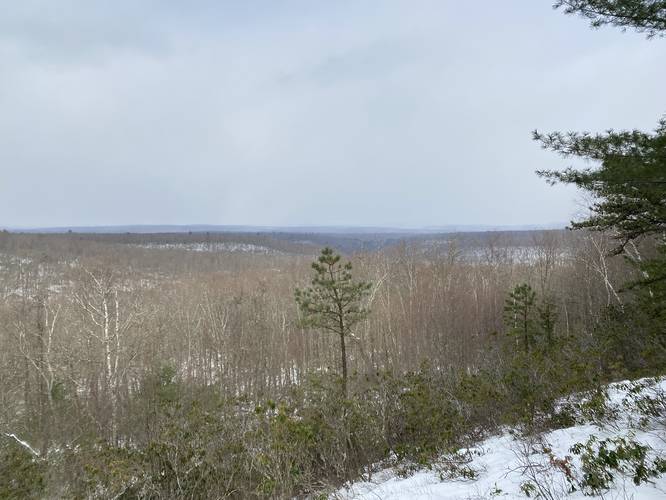
White Birch Vista - Mile 1.35
Around mile 1.35, hikers will reach the spur trail that leads to the White Birch Vista. At the end of this spur trail is a sweeping view facing north at the White Birch Vista, located around mile 1.45.
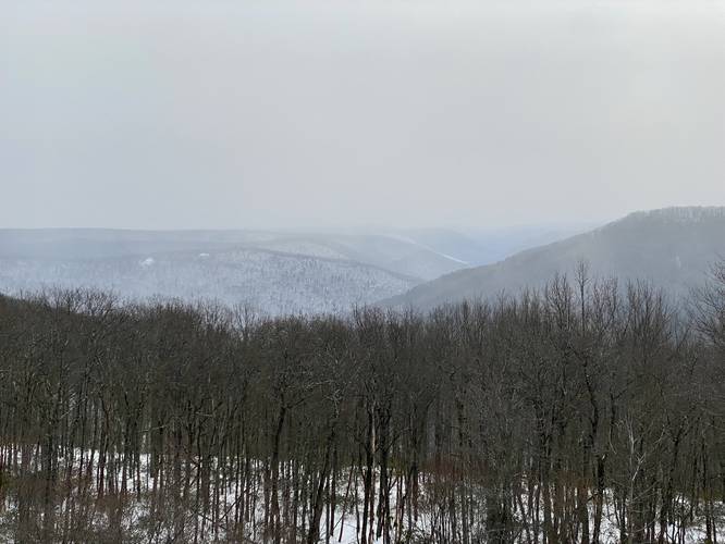
Moss Hollow Lookout - Mile 1.65
After visiting the White Birch Vista, hikers will continue heading east along the Black Forest Trail to reach the Moss Hollow Lookout spur trail around mile 1.65, with the vista located around mile 1.7. Hike down this short path to reach a stunning view into Pine Creek Gorge (the PA Grand Canyon) with Hemlock Mountain in the foreground and Pine Creek Gorge in the background.
Hiking out from Moss Hollow Lookout is identical but opposite to the hike in, but it's worth taking a break at Moss Hollow Lookout before heading back.
Parking
Hikers will find a large parking lot along Manor Fork Rd in Brown, PA (just before the junction with Moss Fork Rd). The lot is large enough to fit a half-dozen vehicles or more and is located near a state forest maintenance facility and some camps.
Pets
Dogs are allowed if leashed and their waste should be carried out by the hiker.
Camping and Backpacking
While we did find any pre-built campsites along the Gas Line Trail or the Black Forest Trail, hammock campers can easily find a spot to setup (and leave no trace) along this route. The Black Forest Trail is one of the most popular backpacking trails in Pennsylvania, however, so it's not difficult to find an actual campsite along the BFT. Please follow all state forest rules and regulations when backcountry / dispersed / primitive camping.
Winter Snowshoeing
This trail is great for winter snowshoeing since the parking lot is accessible in the winter and the elevation grade of this trail is very low, making for an easier snowshoe hike. Depending on how deep the snow is, snowshoeing may be a bit more difficult than your average non-snowy hike.
Hazards
During the warm months - between the end of April and early October - the Timber Rattlesnake can be found living in these woods. Be on the lookout for them and give them space and respect if you find one.
Biking
Please note that biking is permitted along the Gas Line Trail, but NOT the Black Forest Trail.
Trails
This hike follows two named trails: Gas Line Trail (blue blazes), Black Forest Trail (BFT; orange blazes). For the majority of the hike, this trail follows blue blazes, hence the main blaze color.
Hike Description
This hike begins at the junction of Moss Fork Rd and Manor Fork Rd in Brown, Pennsylvania and follows the Gas Line Trail due east toward the Black Forest Trail (BFT). The Gas Line Trail begins along Moss Fork Rd with a yellow and black gate - meaning foot traffic only.
There's not much to see along the Gas Line Trail - or even the Black Forest Trail - for the majority of the hike aside from a mix of hardwood trees, including the red oak, pines, and mountain laurel that line the trail.
Black Forest Trail Junction - Mile 1.2
Around mile 1.2, hikers will reach the Black Forest Trail. Just continue straight (do not hike down the mountain) to stay along the mountain's ridge to reach both vista points.
White Birch Vista - Mile 1.35
Around mile 1.35, hikers will reach the spur trail that leads to the White Birch Vista. At the end of this spur trail is a sweeping view facing north at the White Birch Vista, located around mile 1.45.
Moss Hollow Lookout - Mile 1.65
After visiting the White Birch Vista, hikers will continue heading east along the Black Forest Trail to reach the Moss Hollow Lookout spur trail around mile 1.65, with the vista located around mile 1.7. Hike down this short path to reach a stunning view into Pine Creek Gorge (the PA Grand Canyon) with Hemlock Mountain in the foreground and Pine Creek Gorge in the background.
Hiking out from Moss Hollow Lookout is identical but opposite to the hike in, but it's worth taking a break at Moss Hollow Lookout before heading back.
Parking
Hikers will find a large parking lot along Manor Fork Rd in Brown, PA (just before the junction with Moss Fork Rd). The lot is large enough to fit a half-dozen vehicles or more and is located near a state forest maintenance facility and some camps.
Pets
Dogs are allowed if leashed and their waste should be carried out by the hiker.
Camping and Backpacking
While we did find any pre-built campsites along the Gas Line Trail or the Black Forest Trail, hammock campers can easily find a spot to setup (and leave no trace) along this route. The Black Forest Trail is one of the most popular backpacking trails in Pennsylvania, however, so it's not difficult to find an actual campsite along the BFT. Please follow all state forest rules and regulations when backcountry / dispersed / primitive camping.
Winter Snowshoeing
This trail is great for winter snowshoeing since the parking lot is accessible in the winter and the elevation grade of this trail is very low, making for an easier snowshoe hike. Depending on how deep the snow is, snowshoeing may be a bit more difficult than your average non-snowy hike.
Hazards
During the warm months - between the end of April and early October - the Timber Rattlesnake can be found living in these woods. Be on the lookout for them and give them space and respect if you find one.
Biking
Please note that biking is permitted along the Gas Line Trail, but NOT the Black Forest Trail.