Loading...

🎉 Enjoy a Free 7-Day Supporter Trial and Unlock Exclusive Perks — No Credit Card Required. Learn more.

Morrow Mountain and Sugarloaf Mountain Hike

Directions
Map
Pictures
Send to App
Distance:
6.9 Miles / 11.1 km
Type:
Out-and-Back
Difficulty:
Moderate
Time to Hike:
3 hours, ~27 minutes
Features:
Surface Type:
Dirt
Town:
Albemarle, North Carolina
Directions:
35.371626, -80.096071
Added:
April 02, 2025
Updated:
April 06, 2025
Copy Trail Link Hiking this trail? Send a friend or family member a link to this trail guide for your own safety. Hike at your own risk (disclaimer)
Loading...
Loading...
496'

Total Change
1,373'

Ascent
1,373'

Descent

Download the Trail Route for Offline Use

Supporters get exclusive access to download trail routes to the MyHikes app for offline use. Stay prepared on your adventure, even without an internet connection! Become a Supporter today to unlock this feature and hike with confidence.

Send to App

Morrow Mountain and Sugarloaf Mountain Hike

Morrow Mountain State Park is located in the southwest corner of the ancient Uwharrie Mountains of central North Carolina. Erosion has worn down these previously tall coastal mountains, and now they are merely rocky, forested hills. The state park has many loop options perfect for day hiking or backpacking. This hike begins at the park entrance and crosses the two tallest peaks in the park, Sugarloaf Mountain and Morrow Mountain.

First you’ll climb the long backbone of Sugarloaf Mountain with winter views of the region. The highlight of the park is the Mountain Loop Trail around Morrow Mountain, which features great views south of Lake Tillery and Stony Mountain, and northeast of Uwharrie National Forest. At the summit you can enjoy the picnic tables and shelter under a dogwood canopy before turning around and completing the hike. Morrow Mountain will surprise you in many ways, this is a great state park to visit if you are looking for a mountain experience close to the largest cities in the state.

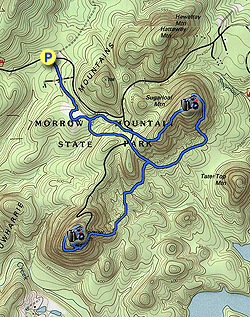
  • Mile 0.0 – The Bridle Long Loop Trail (red circle blaze) begins behind the stone building at the park entrance.
  • Mile 0.2 – Pass through the ranger residence area following service roads.
  • Mile 0.3 – The Bridle Long Loop Trail splits right leaving a service road.
  • Mile 0.55 – The Bridle Long Loop Trail curves right passing by the horse trailer parking lot. Leave the bridle trail and walk towards the entrance of the parking lot.
  • Mile 0.7 – Begin the Sugarloaf Mountain Trail (orange diamond blaze) heading east.
  • Mile 0.75 – The Sugarloaf Mountain Trail loop splits, go left on the northern section which parallels the road and then ascends the mountain.
  • Mile 1.1 – Cross Morrow Mountain Rd. After the crossing the trail begins a continuous 300-foot climb for 0.6-mi to the summit of Sugarloaf Mountain. As you climb you’ll get good winter views of Morrow Mountain to the south and the Pee Dee River to the east.
  • Mile 1.8 – Reach the top of Sugarloaf Mountain, the second tallest peak in the state park at 858 feet. The summit is lightly forested with a large patch of grass amidst the trees. Beyond the summit the trail begins descending a narrow path cut into a steep slope and turns east then south with good winter views.
  • Mile 2.3 – Sugarloaf Mountain Trail intersects the Morrow Mountain Trail (blue triangle blaze) and Backpack Trail (white circle blaze) at a T-junction. Turn right following all trails southwest.
  • Mile 2.5 – T-junction with the Backpack Trail (white circle blaze) heading left to backcountry campsites.
  • Mile 2.9 – At a T-junction turn left on the Morrow Mountain Trail leaving the Sugarloaf Mountain Trail loop.
  • Mile 3.3 – Walk through a cross intersection with the Bridle Short Loop Trail (white circle blaze) and Bridle Middle Loop Trail (blue circle blaze). The trail soon ascends Morrow Mountain. You’ll encounter the steepest section of the hike beginning at Mile 3.5 when the trail ascends 400 feet in 0.4-mi. This gradient will surely surprise you and everyone else on the trail, it is equivalent to many tough Blue Ridge hikes.
  • Mile 3.9 – Morrow Mountain Trail ends at the Mountain Loop Trail (red square blaze), turn left at the split beginning the loop. The trail encircles the southern rim of the mountain which has been scarred by fires and has open views south and east. Directly south you’ll see Stony Mountain and Lake Tillery.
  • Mile 4.4 – Mountain Loop Trail passes by the summit of Morrow Mountain (906 feet). Leave the trail to explore the top. The road ends at a cul-de-sac with an open view northeast of the vast Uwharrie Mountains surrounding the Yadkin and Uwharrie Rivers. The Pee Dee River is formed by the confluence of these two rivers on the right side of the view. A stone wall beautifully lines the parking spots along the road offering similar views to those you had on the trail below. There are many picnic tables on the grassy summit surrounded by dogwood trees. To continue the hike head south towards the lower end of the parking area to resume the Mountain Loop Trail. (Note this GPS track contains an extra 0.3-mi of wandering around the summit.)
  • Mile 4.9 – Follow the Mountain Loop Trail downhill to the left away from the road.
  • Mile 5.0 – At the end of loop follow the Morrow Mountain Trail down the steep slope of the mountain.
  • Mile 6.0 – Turn left on the Sugarloaf Mountain Trail (orange diamond blaze) at the T-junction.
  • Mile 6.2 – Cross Morrow Mountain Rd.
  • Mile 6.6 – Sugarloaf Mountain Trail ends at the horse trailer parking lot. Walk to the end of the lot to pick up the Bridle Long Loop Trail (red circle blaze).
  • Hike 6.9 – Hike ends at the park entrance gate.
By HikingUpward Contributor: Zach Robbins
Explore 2 trails near Albemarle, NC
  1. Parking

    35.371626, -80.096071
  2. Main Trailhead

    35.371626, -80.096071
No community routes found. To add your own hike as a Community Route for this Trail guide, leave a Trip Report with an attached GPX file.

Hazards

Snakes
Poison Ivy/Oak

Seasons

All

Trip Reports

Trail Guide By:
HikingUpward user profile picture
6.9 miles / 11.1 km

Weather Forecast

In Albemarle, NC

Explore Hiking Trails

You May Also Like

Colorado's Million Dollar Highway - Plan a day's drive adventure along the iconic Million Dollar Highway in Colorado. Explore the best short trails, roadside stops, waterfalls, vistas, ghost towns, and hot springs within a ~6 hour road trip.
Explore

Colorado's Million Dollar Highway

Plan a day's drive adventure along the iconic Million Dollar Highway in Colorado. Explore the best short trails, roadside stops, waterfalls, vistas, ghost towns, and hot springs within a ~6 hour road trip.

Read
Glacier's Going-to-the-Sun Road - Discover the breathtaking beauty of Glacier National Park along the iconic Going-to-the-Sun Road. From stunning roadside stops to picturesque waterfalls and vistas, this engineering marvel offers endless opportunities for exploration.
Explore

Glacier's Going-to-the-Sun Road

Discover the breathtaking beauty of Glacier National Park along the iconic Going-to-the-Sun Road. From stunning roadside stops to picturesque waterfalls and vistas, this engineering marvel offers endless opportunities for exploration.

Read
New York's Best Waterfalls - Whether you're planning a day hike, roadside stop, or a leisurely short walk, this guide provides hikers, travelers, and locals alike with 63 different locations to over 100 scenic waterfalls to help plan your next adventure!
Explore

New York's Best Waterfalls

Whether you're planning a day hike, roadside stop, or a leisurely short walk, this guide provides hikers, travelers, and locals alike with 63 different locations to over 100 scenic waterfalls to help plan your next adventure!

Read
25 Best Day Hikes in North Carolina - Discover the top 25 best day hikes in North Carolina, from breathtaking waterfalls to mountain peaks. Explore hidden gems, scenic views, and trails suitable for all skill levels, perfect for your next outdoor adventure.
Explore

25 Best Day Hikes in North Carolina

Discover the top 25 best day hikes in North Carolina, from breathtaking waterfalls to mountain peaks. Explore hidden gems, scenic views, and trails suitable for all skill levels, perfect for your next outdoor adventure.

Read

Before you boogie...

Find our trail guides useful? Consider becoming a Supporter to unlock perks!

MyHikes is an indie platform that makes exploring public trails easier for everyone. The platform has no investors, no ads, and is owned and operated by one person, Dave Miller. Dave has personally mapped and written over 1,800 trail guides on MyHikes for the public to explore. MyHikes has helped millions outdoor enthusiasts plan their next adventure.

But it takes a lot of time 🕦, money 💰, work, and espresso shots ☕ to run MyHikes, including hiking , mapping , writing , and publishing new trails with high-quality (accurate) information... along with software engineering (coding) the platform like building new features, website and mobile app development (iOS and Android), site maintainance . and much much more.

Supporters unlock website and mobile app perks with an annual one-time payment of $25 (you renew) 😎👍. Or you can simply make a Donation of your choice. Otherwise, you can support us by telling your friends about MyHikes - both quick and free 🎉

Admin user profile picture

Dave Miller
MyHikes Founder