Loading...

🎉 Enjoy a Free 7-Day Supporter Trial and Unlock Exclusive Perks — No Credit Card Required. Learn more.

Morgan Run Hike

Directions
Map
Pictures
Send to App
Distance:
8.7 Miles / 14.0 km
Type:
Loop
Difficulty:
Hard
Time to Hike:
4 hours, ~21 minutes
Features:
Surface Type:
Dirt
Park:
George Washington National Forest
Town:
Shenandoah, Virginia
Directions:
38.525192, -78.660716
Added:
February 17, 2025
Updated:
April 05, 2025
Copy Trail Link Hiking this trail? Send a friend or family member a link to this trail guide for your own safety. Hike at your own risk (disclaimer)
Loading...
Loading...
1,103'

Total Change
1,867'

Ascent
1,861'

Descent

Download the Trail Route for Offline Use

Supporters get exclusive access to download trail routes to the MyHikes app for offline use. Stay prepared on your adventure, even without an internet connection! Become a Supporter today to unlock this feature and hike with confidence.

Send to App

Morgan Run Hike

Morgan Run, on the southern end of the Massanutten mountain range, passes the wonderful Fridley Gap swimming hole that is also accessible on the Fridley Gap Hike. Mountain streams and waterfalls are at every turn on the Morgan Run section of this secluded loop hike.

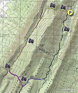
After parking, continue walking along the Cub Run gravel forestry road as it gently ascends the valley. This forestry road is not heavily traveled, however, keep an ear out as one or two vehicles may pass by before you reach the intersection of the Martin Bottom Trail 3.0 miles from where you parked.

Turn right up the blue blazed Martin Bottom trail as it climbs through the pass before arriving at the purple blazed Fridley Gap Trail. The blue blazes of the Martin Bottom Trail end, and at this point the trail continues as the purple blazed Fridley Gap Trail.

Turn right uphill on the purple blazed Fridley Gap Trail for the steepest portion of the hike as it climbs Third Mountain, crosses the ridge, then very steeply descends to the intersection of the orange blazed South Trail.

Turn left downhill for 150 yards, then turn right at the post, cross a small run and in 75 yards the Fridley Gap swimming hole will be on your left. This is an excellent place for lunch and a swim in the late summer.

To continue, retrace your steps back over the run, turn left up the orange blazed South Trail, again passing the purple blazed Fridley Gap Trail descended earlier. Continue on the orange blazed trail for 2.8 miles as it crosses Morgan Run several times, cresting the high point then gradually descending and meeting the intersection of the yellow blazed Morgan Run Trail on your right.

Turn right on the narrower yellow blazed Morgan Run Trail which in 200 yards meets Morgan Run then descends through the gap. The trail is rocky in places as it crosses back and forth across the run, passing small waterfalls and old growth forest. 1.2 miles after joining the yellow blazed Morgan Run Trail pass a campsite on your right and emerge onto the forestry road returning to the parking area.

Explore 94 trails near Shenandoah, VA
  1. Parking

    38.525192, -78.660716
  2. Main Trailhead

    38.525222, -78.660779
No community routes found. To add your own hike as a Community Route for this Trail guide, leave a Trip Report with an attached GPX file.

Hazards

Ticks - Lyme Disease More Info (CDC)
Snakes
Poison Ivy/Oak

Seasons

All

Photo Albums

Trip Reports

Trail Guide By:
HikingUpward user profile picture
8.7 miles / 14.0 km

Weather Forecast

In Shenandoah, VA

Explore Hiking Trails

You May Also Like

New York's Best Waterfalls - Whether you're planning a day hike, roadside stop, or a leisurely short walk, this guide provides hikers, travelers, and locals alike with 63 different locations to over 100 scenic waterfalls to help plan your next adventure!
Explore

New York's Best Waterfalls

Whether you're planning a day hike, roadside stop, or a leisurely short walk, this guide provides hikers, travelers, and locals alike with 63 different locations to over 100 scenic waterfalls to help plan your next adventure!

Read
25 Best Day Hikes in North Carolina - Discover the top 25 best day hikes in North Carolina, from breathtaking waterfalls to mountain peaks. Explore hidden gems, scenic views, and trails suitable for all skill levels, perfect for your next outdoor adventure.
Explore

25 Best Day Hikes in North Carolina

Discover the top 25 best day hikes in North Carolina, from breathtaking waterfalls to mountain peaks. Explore hidden gems, scenic views, and trails suitable for all skill levels, perfect for your next outdoor adventure.

Read

Before you boogie...

Find our trail guides useful? Consider becoming a Supporter to unlock perks!

MyHikes is an indie platform that makes exploring public trails easier for everyone. The platform has no investors, no ads, and is owned and operated by one person, Dave Miller. Dave has personally mapped and written over 1,800 trail guides on MyHikes for the public to explore. MyHikes has helped millions outdoor enthusiasts plan their next adventure.

But it takes a lot of time 🕦, money 💰, work, and espresso shots ☕ to run MyHikes, including hiking , mapping , writing , and publishing new trails with high-quality (accurate) information... along with software engineering (coding) the platform like building new features, website and mobile app development (iOS and Android), site maintainance . and much much more.

Supporters unlock website and mobile app perks with an annual one-time payment of $25 (you renew) 😎👍. Or you can simply make a Donation of your choice. Otherwise, you can support us by telling your friends about MyHikes - both quick and free 🎉

Admin user profile picture

Dave Miller
MyHikes Founder