Loading...

WINTER SALE! 50% OFF Supporter Accounts — now through January 31st. Learn More.

Moorman's River Hike

This area was dramatically changed in June 1995 when 11.5 inches of rain triggered multiple landslides. A great hike for swimming holes and when the water is flowing there are two waterfalls on the Big Branch spur trail. Don’t expect much solitude on this hike as it is popular due to the swimming holes. The Sugar Hollow Dam was used in a scene at the beginning of the movie “Evan Almighty”.

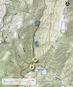
There are two parking areas, one just a little beyond the Sugar Hollow Reservoir on the left on a gravel road and one 0.5 miles up the gravel road (room for about 8 cars). This portion was pretty rutted and had some huge rocks in the road. A car/truck with good clearance should have no problem getting to the 2nd parking area. We began the hike at the first parking area, plenty of spaces. From the 1st parking area, continue walking 0.5 miles on the North Fork Moorman’s Road (gravel road) until you reach the second parking area, the yellow-blazed North Fork Moorman’s River trail is straight ahead.

0.4 miles from the 2nd parking area you will reach a huge swimming hole, impressive even with the lack of water flow in the river in August. For the next 1.4 miles until the Big Branch spur trail intersection you will cross the river about 3 more times.

HU Note: In the Spring with good water flow, some of these crossings might be a little tricky. Good shoes and hiking poles would be beneficial.

Keep your eyes open for other swimming holes and some of the damage from the 1995 flood. At the intersection bear left and you will reach the 1st falls in about 70 yards. The more impressive larger falls is about another 80 yards upstream. Of course “impressive” was relative on our trip due to the time of year and lack of water in August. We have seen photos of it in the Spring and it is impressive. The falls would also have decent size swimming holes.

To return to the parking area, turn right at the intersection and retrace your steps. We explored many of the other swimming holes on the return trip.

Note: If you need an additional workout you could continue on the N.F. Moorman’s River trail by taking a left at the intersection, reaching Skyline Drive at Black Rock Gap in 3.7 miles.

Explore 52 trails near Crozet, VA

Know Before You Go

  • Moorman's River Hike in Crozet, VA, is a 4.2-mile trail known for its swimming holes and, during periods of high water flow, two waterfalls on the Big Branch spur.
  • The trail is popular and can be crowded, especially during swimming season; it features multiple river crossings that may be challenging in the spring.
  • The Sugar Hollow Dam near the trailhead was used in the movie "Evan Almighty," and the area shows visible damage from a 1995 flood.
Interactive topographic map for Moorman's River Hike located in Crozet, VA. Click the "View Map" button to load GPS coordinates and trail markers.
Get directions
Distance
4.2 mi
Difficulty
Easy
Type
Out-and-Back
Est. Time
2.1 hrs
Elev. Gain
592'
Rating
3.9
Added
March 18, 2025
Updated
April 05, 2025

Weather Forecast

Loading...
Total Change
555'
Ascent
592'
Descent
590'
Loading...

Download the GPX Data for Offline Use

Supporters get exclusive access to download trail routes to the MyHikes app for offline use. Stay prepared on your adventure, even without an internet connection! Become a Supporter today to unlock this feature and hike with confidence.

Download Moorman's River Hike GPX Data to the MyHikes Mobile App

Features

Dogs
Waterfalls
Water Source

Points of interest

  1. Parking

    38.139315, -78.749674
  2. Main Trailhead

    38.139417, -78.749442

Safety information

For your own safety: plan ahead, let someone know where you'll be, and hike at your own risk.

Hazards

Snakes (Rattlesnakes, Copperheads, others)
Poison Ivy or Poison Oak

Markers

Blaze Color

Yellow

Availability

All seasons

Surface type

Dirt

Trip Reports (Reviews)

Rated 3.94 out of 5 based on 18 ratings.

Ready to help fellow hikers? Add a trip report to share your experience and provide valuable insights for other hikers!

By: Threehikers
4.2 miles / 6.8 km
June 28, 2017
Arrived at the trailhead early on a beautiful morning and it was a good thing as the lot was overflowing when we finished around noon. The hike is easy and a well worn path but nice as it parallels and crosses the river. The hike to the top of the last falls gives a nice place to take a break. The trail past the last falls is uneventful but a nice walk. We went to where the road tuns and on the way ck down once we reached the river it was crowded the rest of the way with swimmers, families and groups enjoying the rare nice weather for the end of June.
Legacy Review
By: Martha & Rick
4.2 miles / 6.8 km
May 29, 2017
This was a lovely hike and easy for us seniors. However, since it was just after some heavy rains, the four river crossings were about calf-deep. Not difficult, just bear in mind you will get your feet wet! The trails were also pretty muddy, some with water running down them as well. The only scary part of the hike was the parking situation: on Memorial Day, the lot was full, and cars were parked on either side of the skinny winding road leading to the lot, so there was a lot of freaky backing up when you encountered a car coming from the opposite direction!
Legacy Review
By: Fergus & Henri
4.2 miles / 6.8 km
March 05, 2017
This is a fun, pretty, easy, water-feature hike near Charlottesville that offers big pay off for low effort. Excellent low-key hike for when you want some pretty Virginia scenery and fresh air, without all that pesky UP. Because we went in early March, it wasn't crowded at all...but I don't think I'd go back in peak season, given its popularity. Important note: There were 7+ trees downed over the trail as we started out. It may take some time before they get cleared away. They are passable, but should be noted. See our blog for more about our experience (and photos): http://wp.me/p8ebJj-BJ
Legacy Review
No community routes found. To add your own hike as a Community Route for this Trail guide, leave a Trip Report with an attached GPX file.

Popular categories

Scenic mountain view representing vista trails
Vista trails
Scenic gorge of cascades representing waterfall trails
Waterfall hikes
Rugged mountain terrain representing summit trails
Summit trails
Scenic mountain view representing dog-friendly trails
Dog-friendly
Scenic campsite with a view representing camping trails
Camping trails
Appalachian Trail logo representing A.T. hikes
A.T. hikes

You May Also Like

25 Best Day Hikes in North Carolina - Discover the top 25 best day hikes in North Carolina, from breathtaking waterfalls to mountain peaks. Explore hidden gems, scenic views, and trails suitable for all skill levels, perfect for your next outdoor adventure.
Explore

25 Best Day Hikes in North Carolina

Discover the top 25 best day hikes in North Carolina, from breathtaking waterfalls to mountain peaks. Explore hidden gems, scenic views, and trails suitable for all skill levels, perfect for your next outdoor adventure.

Read
🍪 We use cookies to learn about site usage and to serve map tiles. You may block cookies manually in the browser. By continuing you agree. Learn more