Moores Knob, the tallest peak in the Sauratown Mountains, is home to a beautiful stone lookout tower with outstanding 360-degree views. The 4.7-mile moderately strenuous Moore’s Wall Loop Trail is a very popular hike in Hanging Rock State Park. If the distance and elevation gain for the Five Peaks Loop is a deterrent, this is a great alternative with less foot traffic than the namesake Hanging Rock. Starting at Hanging Rock Park Lake, the trail is mostly level until you leave the confines of the flat water and begin ascending towards Huckleberry Gap. When the loop turns north, you’ll begin a 600+ foot ascent over 1.4 miles to the top of Moores Knob. As you crest Huckleberry Ridge, the trail passes by many fantastic rock formations begging for exploration. The stone lookout tower and the expansive cliffs from the top of Moores Knob (2,579 feet) provide views of the state park, Sauratown Mountain, Pilot Mountain, and the Blue Ridge Escarpment of North Carolina and Virginia. The hike down is much steeper, but substantial trail upgrades in 2007 included many stone and wooden steps to reduce erosion, making this manageable in either direction. Once you reach the lake, you are almost finished with the hike. Before you return to the car, make sure to check out the view of Moores Knob from the pier. The tower is visible more than 900 feet above the lake.
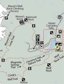
- Mile 0.0 – Park at Hanging Rock Park Lake. The Moore’s Wall Loop Trailhead (red circle blaze) is located beside the boathouse.
- Mile 0.1 – Y-junction with the Cook’s Wall Trail (white diamond blaze) and Chestnut Oak Nature Trail (no blaze) on the left.
- Mile 0.4 – After a long boardwalk at the tip of the lake, you’ll pass by three trail junctions. First, you’ll pass the Chestnut Oak Nature Trail on the left immediately before a small footbridge. Next, you’ll intersect with the Fishing Path (white circle blaze) on the right. Lastly, the Moore’s Wall Loop Trail splits at a Y-junction. Turn left heading east beside the East Fork of Cascade Creek. You will return to this intersection when you finish the loop. The other direction is a long climb on many steps to reach the summit if you choose this option.
- Mile 1.1 – T-junction with the Magnolia Springs Trail (blue square blaze) on the left.
- Mile 1.6 – Turn right on the Moore’s Wall Loop Trail and Mountains-to-Sea Trail (white blaze) at a T-junction with the Tory’s Den Trail. The Mountains-to-Sea Trail continues west following the Tory’s Den Trail (blue circle blaze) from this intersection. From here the trail climbs moderately over 600 feet along Huckleberry Ridge towards Moores Knob.
- Mile 2.8 – Pass beneath and between massive rock outcrops. Above to the left a large outcrop points to the sky like a finger.
- Mile 2.9 – T-junction with the summit trail on the left. A short path straight ahead leads to Balanced Rock.
- Mile 3.0 – Reach the summit of Moores Knob (2,579 feet), the high point of the Sauratown Mountains. The 18-foot stone lookout tower was built in 1951. After Hurricane Hazel severely damaged the tower in 1954, the top cab was removed creating an open-top observation platform. The tower has fantastic 360-degree views of the Piedmont, Sauratown Mountains, and Blue Ridge Mountains. Due east the cliffs of Hanging Rock rise high above the visitors center and Hanging Rock Park Lake. The ridge containing Wolf Rock connects Hanging Rock to Cooks Wall. The double-topped Cooks Wall Mountain rises south above Huckleberry Gap with Cooks Wall on the left and Devils Chimney on the right. Beyond the left side of Cooks Wall, you can pick out the skyscrapers of Winston-Salem. The other two prominent peaks of the Sauratown Mountains lie due west. Sauratown Mountain is the elongated peak in the foreground with communication towers, and the recognizable Pilot Mountain monadnock is directly behind. On crystal clear days you may be able to see Mt. Mitchell to the immediate left of Pilot Mountain, and Grandfather Mountain and Elk Knob on the right. Just north of west are the peaks of Doughton Park and Stone Mountain State Park beyond the Yadkin Valley. Fisher Peak is the most notable summit of the Blue Ridge Escarpment in this direction on the state border. Due northwest, the whaleback summit of Buffalo Mountain rises high above the escarpment in Virginia. The prominent peak due north is Bull Mountain, with the smaller No Business Mountain on the right. Between these two mountains in the distance is Rocky Knob above Rock Castle Gorge.
- Mile 3.1 – Continue left down the Moore’s Wall Loop Trail, which descends over 700 feet on many steps for the next mile.
- Mile 4.1 – Rock hop the West Fork of Cascade Creek.
- Mile 4.2 – Turn right briefly following Campground Rd, then turn left leaving the road in ~100 feet.
- Mile 4.5 – After finishing the loop, turn left on the Fishing Path (white hexagon blaze). The Fishing Path winds around the north side of Hanging Rock Park Lake, adding a little distance to the end of your hike. This trail is easy to follow and underutilized, and provides many nice trailside views of the lake.
- Mile 4.9 – Pass by Hanging Rock Park Lake Dam on the right.
- Mile 4.95 – Fishing Path turns right briefly following Campground Rd across a bridge over the East Fork of Cascade Creek.
- Mile 5.0 - On the other side of the bridge turn right leaving the road and pass beside the dam.
- Mile 5.1 – Closely follow the shoreline of the lake towards the pier.
- Mile 5.2 – Hanging Rock Park Lake Pier provides a great view of Moores Knob rising 900 feet above the lake. You should be able to spot the lookout tower on the left side of the summit.
- Mile 5.3 – Hike ends at the lake parking lot.