Loading...

WINTER SALE! 50% OFF Supporter Accounts — now through January 31st. Learn More.

Molly's Knob Hike

You’ll have to go to Southwest Virginia to hike this trail. It's one of the best maintained trails we have been on with some great views, the best being at Molly Knob. The trail is not too strenuous except for the Molly Knob Vista Trail. There are sections of the trail with thick coverings of rhododendron on either side that will be absolutely beautiful when blooming.

There is a large lake that is part of the park with the last 2 miles of the trail paralleling the lake shore for much of that. At the end of the hike we stopped at the amphitheater bridge and got a great reflection photo.

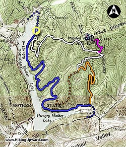
The trail starts at the parking area for the Molly Knob Trail near the CCC Cabins. After parking, go uphill on the road for about 100 yards to the Trail Kiosk. Take a right at the kiosk onto the white-blazed Molly Knob Trail. You will catch a couple of good views of the lake before you reach the Ridge Trail intersection in 0.4 miles. Bear to the left to stay on the Molly Knob Trail.

There is a viewing deck at this intersection looking up to Molly Knob. Continue for another 0.9 miles on a wide but steady upward trail until the Molly’s Vista Trail intersection. Take a left onto the purple-blazed Molly’s Vista Trail and go 0.4 to reach the top of the Knob and the best views of the day. This is the toughest part of the whole hike. If you go a little downhill beyond the benches you should catch a glimpse of the lake. Enjoy the views, eat some lunch, and then retrace your path back to the intersection.

Take a left to get back onto the white blazed Molly’s Knob trail and in 0.5 mile reach the CCC Trail intersection. Bear to the left onto the orange-blazed CCC Trail, do not take the right onto the CCC Trail unless you want to cut off about 1 mile from the hike. You are going the right way if you see a sign saying “Boat Ramp Parking 1.2 miles”. You will reach the Lake Trail Loop intersection in 1.0 miles as you follow a creek.

Bear right onto the blue-blazed Lake Trail Loop heading towards the Beach Overlook. You will see the boat landing area not long after being on this trail. The CCC Trail intersection is on your right in 0.8 miles but stay straight. Go in and out of 2 deep switchbacks around creeks before reaching the Ridge Trail Intersection on your right in 1.4 miles. The last intersection is reached in 0.4 miles, bear to the right and go 100 yards to complete the hike, returning to the Parking Area.
Explore 14 trails near Marion, VA

Know Before You Go

  • Molly's Knob Trail in Marion, VA is a well-maintained 6.3-mile hike featuring lake views, rhododendron thickets, and the best vista from Molly Knob itself, which is reached via a short but strenuous spur trail.
  • The trail is generally moderate, but be prepared for a steep climb on the purple-blazed Molly's Vista Trail to reach the summit.
  • The route includes a variety of trail types (Molly Knob Trail, CCC Trail, Lake Trail Loop), intersections, and blazes (white, purple, orange, blue), so pay attention to the directions and signage.
Interactive topographic map for Molly's Knob Hike located in Marion, VA. Click the "View Map" button to load GPS coordinates and trail markers.
Get directions
Distance
6.3 mi
Difficulty
Hard
Type
Loop
Est. Time
3.2 hrs
Elev. Gain
2,020'
Rating
4.4
Added
April 03, 2025
Updated
April 06, 2025

Weather Forecast

Loading...
Total Change
1,073'
Ascent
2,020'
Descent
2,031'
Loading...

Download the GPX Data for Offline Use

Supporters get exclusive access to download trail routes to the MyHikes app for offline use. Stay prepared on your adventure, even without an internet connection! Become a Supporter today to unlock this feature and hike with confidence.

Download Molly's Knob Hike GPX Data to the MyHikes Mobile App

Features

Vista / Lookout Point
Dogs
Mountain Summit
Water Source

Points of interest

  1. Parking

    36.885593, -81.521398
  2. Main Trailhead

    36.885593, -81.521398

Safety information

For your own safety: plan ahead, let someone know where you'll be, and hike at your own risk.

Hazards

Snakes (Rattlesnakes, Copperheads, others)
Poison Ivy or Poison Oak

Availability

All seasons

Surface type

Dirt

Trip Reports (Reviews)

Rated 4.4 out of 5 based on 5 ratings.

Ready to help fellow hikers? Add a trip report to share your experience and provide valuable insights for other hikers!

By: David D.
6.3 miles / 10.1 km
June 02, 2018
This was a diverse and challenging hike. I love that the trail follows the lake for such a long time and then also gives you such a fantastic mountain experience as well. Took the opposite path that this site suggests and went along the lake first instead of going up to Molly Knob first, and this probably made the hike much more strenuous. The humidity and minimal breeze on that side of the mountain made the uphill climb extra difficult but getting to the top was more than worth it. This is a fabulous day hike if you are not terribly experienced and looking for a good challenge!
Legacy Review
By: Suzannmd
6.3 miles / 10.1 km
June 23, 2015
If I'm honest, we picked Hungry Mother because of the name. However, the terrain, foliage and views won us over. We followed the recommended path above and enjoyed both the high country views and the lower, densely foliaged, damp lower grounds. It would be a very hard push for those don't get out much, but worth the effort.
Legacy Review
By: James N.
6.3 miles / 10.1 km
August 26, 2012
Im usually a summit guy and base my experiences on the views, but for this park I will make an exception. It was phenomenal all around. The hike up to Molly's knob was very reminiscent of Sharp Top from the Peaks Of Otter, short, gritty trek all around. Great views and you could still make out Mount Rogers to the SSE. The trail was impecable. I did a partial full loop going right instead of left at the CCC trail, cutting off about a mile and then merging with the Lake Trail (blue blaze). Ive been on alot of trails and this one is definitely one of my favorites if nothing else for the foilage. If you're in the NRV , make this one a weekend. Its as good if not better than the Cascades.
Legacy Review
No community routes found. To add your own hike as a Community Route for this Trail guide, leave a Trip Report with an attached GPX file.

Popular categories

Scenic mountain view representing vista trails
Vista trails
Scenic gorge of cascades representing waterfall trails
Waterfall hikes
Rugged mountain terrain representing summit trails
Summit trails
Scenic mountain view representing dog-friendly trails
Dog-friendly
Scenic campsite with a view representing camping trails
Camping trails
Appalachian Trail logo representing A.T. hikes
A.T. hikes

You May Also Like

25 Best Day Hikes in North Carolina - Discover the top 25 best day hikes in North Carolina, from breathtaking waterfalls to mountain peaks. Explore hidden gems, scenic views, and trails suitable for all skill levels, perfect for your next outdoor adventure.
Explore

25 Best Day Hikes in North Carolina

Discover the top 25 best day hikes in North Carolina, from breathtaking waterfalls to mountain peaks. Explore hidden gems, scenic views, and trails suitable for all skill levels, perfect for your next outdoor adventure.

Read
🍪 We use cookies to learn about site usage and to serve map tiles. You may block cookies manually in the browser. By continuing you agree. Learn more