Mine Hole Run Falls at Tioga State Forest near Cedar Run, Pennsylvania is an easy 0.2-mile out-and-back off-trail hike that leads to a scenic rock grotto and 8-foot multi-tier waterfall, Mine Hole Run Falls.
Hike Description
This hike begins at the large parking turnout at the parking coordinates provided, at the junction of Mine Hole Road and Leetonia Road. Hikers will head east to hike between Mine Hole Road and the bridge that spans the creek. At the far end of the bridge is a series of rocks that acts as stairs that leads back down to the banks of Mine Hole Run. The hike upstream from the bridge is easy and mostly open with some obvious foot paths that cut through the trees. Surrounding you are massive white pines that tower overhead, jutting out from large rocky ledges - some boasting neat cave-like structures.
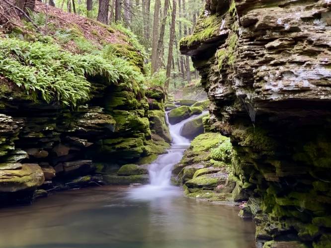
Mine Hole Run Falls - Mile 0.1
The obvious Mine Hole Run Falls presents itself to the hiker around mile 0.1 with its grotto-like rock ledges surrounding the waterfall's deep pool. The rock ledges are about 20-feet tall and surround the turquoise-tinted waters of the deep swimming hole that the waterfall spills into. Mine Hole Run Falls is multi-tiered waterfall, about 8-feet tall in total, that cascades down a series of rock ledges - creating a beautiful and tranquil scene.
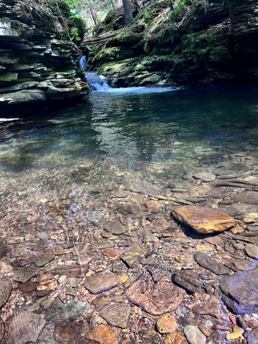
Swimming Hole
During the Summer the water levels are likely lower, but the deep pool provides a decent place to wade or cool off in the water. Technically a swimming hole.
Parking
Hikers will find a large parking lot a the parking coordinates provided - at the junction of Mine Hole Road and Leetonia Road.
Pets
Dogs are allowed if leashed and cleaned up after.
Warning
Bridge Crossing: Not all that dangerous, but the bridge crossing often has weird holes and footing between the concrete bridge and the sloping soil that leads down from the road - to play it safe, walk on the soil or the concrete. Watch your step - falling off the bridge is a ~10-foot fall.
Hike Description
This hike begins at the large parking turnout at the parking coordinates provided, at the junction of Mine Hole Road and Leetonia Road. Hikers will head east to hike between Mine Hole Road and the bridge that spans the creek. At the far end of the bridge is a series of rocks that acts as stairs that leads back down to the banks of Mine Hole Run. The hike upstream from the bridge is easy and mostly open with some obvious foot paths that cut through the trees. Surrounding you are massive white pines that tower overhead, jutting out from large rocky ledges - some boasting neat cave-like structures.
Mine Hole Run Falls - Mile 0.1
The obvious Mine Hole Run Falls presents itself to the hiker around mile 0.1 with its grotto-like rock ledges surrounding the waterfall's deep pool. The rock ledges are about 20-feet tall and surround the turquoise-tinted waters of the deep swimming hole that the waterfall spills into. Mine Hole Run Falls is multi-tiered waterfall, about 8-feet tall in total, that cascades down a series of rock ledges - creating a beautiful and tranquil scene.
Swimming Hole
During the Summer the water levels are likely lower, but the deep pool provides a decent place to wade or cool off in the water. Technically a swimming hole.
Parking
Hikers will find a large parking lot a the parking coordinates provided - at the junction of Mine Hole Road and Leetonia Road.
Pets
Dogs are allowed if leashed and cleaned up after.
Warning
Bridge Crossing: Not all that dangerous, but the bridge crossing often has weird holes and footing between the concrete bridge and the sloping soil that leads down from the road - to play it safe, walk on the soil or the concrete. Watch your step - falling off the bridge is a ~10-foot fall.