The Mill Canyon Dinosaur Bone Trail at the Mill Canyon Dinosaur Trailhead Interpretive Site near Moab, Utah is an easy 0.3-mile loop hike that features several interpretive sites with fossilized dinosaur bones.
Preserve the History
Please do not touch, remove, or take any of the fossils or bones found along this trail -- not only is it illegal to do so, but damaging these ancient artifacts ruins research, history, and fun for future people.
Hike Description
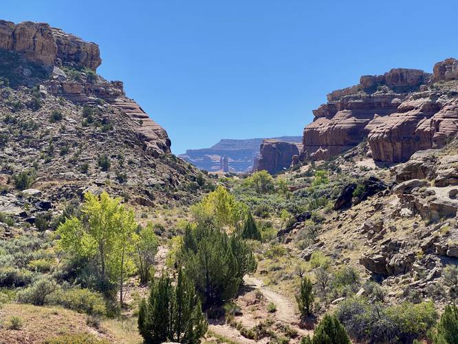
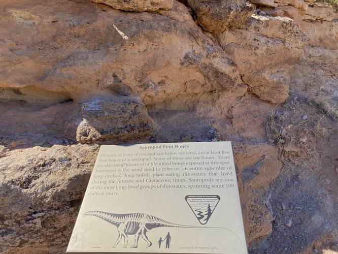
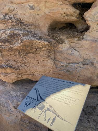
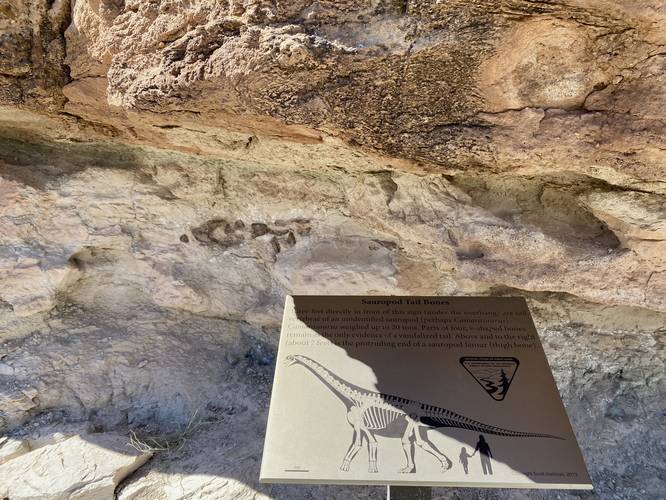
This short hike begins at the main parking lot at the coordinates provided and heads-in along the defined trail that heads southwest from the parking lot to reach an interpretive sign. This sign tells hikers about the Determination Towers -- located straight down the canyon are three rock spires in the distance, that's "Determination Towers", a popular rock climbing spot. Hikers will then head west, downhill, to reach the dinosaur bone trail. The trail itself follows a cliff area where you'll find more interpretive signs along the way that depict the different types of dinosaur bones found within the rock. Note that it's not always easy to find these bones since they blend in so well with their surrounding embedded-rock landscape. Most of the dinosaur bones found along this trail are from an ancient Sauropod.
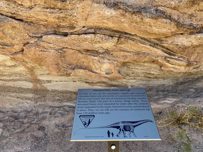
Sauropod (Dinosaur) Bones - Mile 0.7 to 0.12
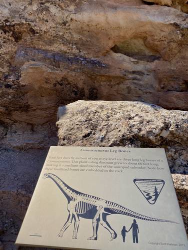
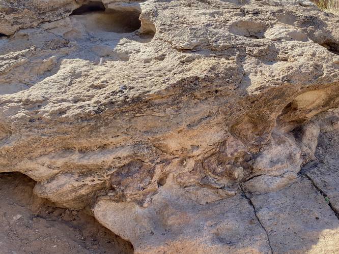
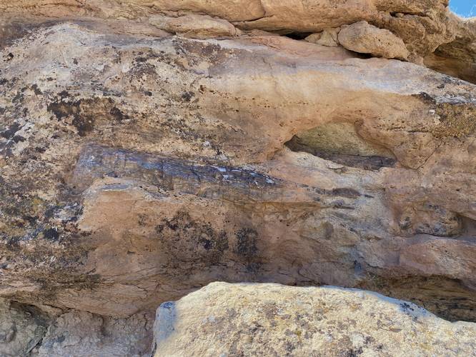
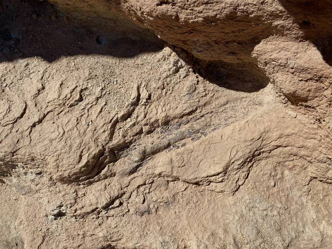
From miles 0.7 to about 0.12, there are several sites along the trail where hikers will find interpretive signs that attempt to show you all of the dinosaur bones within the bedrock. These can sometimes be a bit tricky to locate; however, the bones around mile 0.7 (at the start) are the most-obvious with massive dark-colored leg bones on display within the cliff side. There are other very-obvious fossilized bones along the trail (with interpretive signs) like the shoulder blade of a Sauropod. Some are difficult to find, like the Sauropod vertebrae and other bones. It's really fun to read the signs and try to locate the bones within the rock. Around mile 0.12, hikers will pass the last of the dinosaur bones before the trail skirts its way around the cliff.
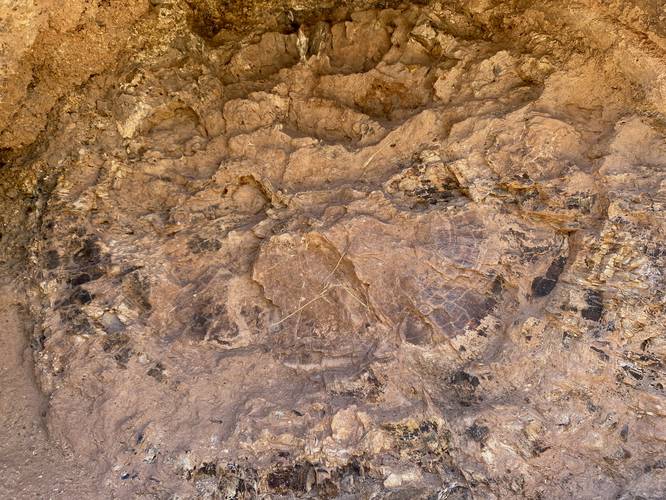
Fossilized Tree Trunk - Mile 0.16
Around mile 0.16, hikers will find a fossilized tree trunk - a circular-shaped hole in the cliff face - that provides a neat view into the ancient past that shows fossilized tree rings.
The trail the meets with a junction along the main "Mill Canyon Trail" where hikers will take a left-hand turn to head back to parking to complete this 0.3-mile loop.
Parking
Hikers will find a medium-sized parking lot at the coordinates provided, large enough to fit over a dozen vehicles as of September 2023.
Pets
Dogs are allowed only if leashed and must be cleaned up after.
Warnings
Sun exposure: This trail has very little shade and no water sources. Pack-in all water and wear sun screen and a hat to protect against sun exposure. It's smart to hike either in the early morning or late afternoon to avoid the intense desert sun.
No water: This trail has no water sources so you must pack-in all water. A general rule of thumb in the desert is 1 gallon of water per person per day.
Rattlesnakes: This is rattlesnake territory, so be on the lookout and give any rattlers you find plenty of space.
Preserve the History
Please do not touch, remove, or take any of the fossils or bones found along this trail -- not only is it illegal to do so, but damaging these ancient artifacts ruins research, history, and fun for future people.
Hike Description
This short hike begins at the main parking lot at the coordinates provided and heads-in along the defined trail that heads southwest from the parking lot to reach an interpretive sign. This sign tells hikers about the Determination Towers -- located straight down the canyon are three rock spires in the distance, that's "Determination Towers", a popular rock climbing spot. Hikers will then head west, downhill, to reach the dinosaur bone trail. The trail itself follows a cliff area where you'll find more interpretive signs along the way that depict the different types of dinosaur bones found within the rock. Note that it's not always easy to find these bones since they blend in so well with their surrounding embedded-rock landscape. Most of the dinosaur bones found along this trail are from an ancient Sauropod.
Sauropod (Dinosaur) Bones - Mile 0.7 to 0.12
From miles 0.7 to about 0.12, there are several sites along the trail where hikers will find interpretive signs that attempt to show you all of the dinosaur bones within the bedrock. These can sometimes be a bit tricky to locate; however, the bones around mile 0.7 (at the start) are the most-obvious with massive dark-colored leg bones on display within the cliff side. There are other very-obvious fossilized bones along the trail (with interpretive signs) like the shoulder blade of a Sauropod. Some are difficult to find, like the Sauropod vertebrae and other bones. It's really fun to read the signs and try to locate the bones within the rock. Around mile 0.12, hikers will pass the last of the dinosaur bones before the trail skirts its way around the cliff.
Fossilized Tree Trunk - Mile 0.16
Around mile 0.16, hikers will find a fossilized tree trunk - a circular-shaped hole in the cliff face - that provides a neat view into the ancient past that shows fossilized tree rings.
The trail the meets with a junction along the main "Mill Canyon Trail" where hikers will take a left-hand turn to head back to parking to complete this 0.3-mile loop.
Parking
Hikers will find a medium-sized parking lot at the coordinates provided, large enough to fit over a dozen vehicles as of September 2023.
Pets
Dogs are allowed only if leashed and must be cleaned up after.
Warnings
Sun exposure: This trail has very little shade and no water sources. Pack-in all water and wear sun screen and a hat to protect against sun exposure. It's smart to hike either in the early morning or late afternoon to avoid the intense desert sun.
No water: This trail has no water sources so you must pack-in all water. A general rule of thumb in the desert is 1 gallon of water per person per day.
Rattlesnakes: This is rattlesnake territory, so be on the lookout and give any rattlers you find plenty of space.