Loading...

๐ŸŽ‰ Enjoy a Free 7-Day Supporter Trial and Unlock Exclusive Perks โ€” No Credit Card Required. Learn more.

Middle Fork Taylor Creek Trail

Directions
Map
Pictures
Send to App
Distance:
5.3 Miles / 8.5 km
Type:
Out-and-Back
Difficulty:
Moderate
Time to Hike:
2 hours, ~39 minutes
Features:
Surface Type:
Dirt
Park:
Zion National Park
Town:
New Harmony, Utah
Directions:
37.461823, -113.199966
Added:
June 20, 2019
Updated:
January 25, 2024
Copy Trail Link Hiking this trail? Send a friend or family member a link to this trail guide for your own safety. Hike at your own risk (disclaimer)
Loading...
Loading...
643'

Total Change
1,063'

Ascent
1,063'

Descent

Download the Trail Route for Offline Use

Supporters get exclusive access to download trail routes to the MyHikes app for offline use. Stay prepared on your adventure, even without an internet connection! Become a Supporter today to unlock this feature and hike with confidence.

Send to App

Middle Fork Taylor Creek Trail

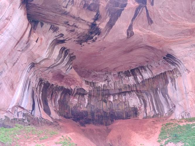
The Middle Fork Taylor Creek Trail at Zion National Park in New Harmony, Utah is a moderate 5.3-mile out-and-back trail that leads hikers through a narrow canyon and out to the Double Arch Alcove, which is a massive sandstone cave that was once carved out by water.

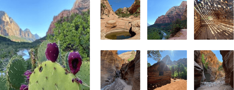
The trail passes through the Kolob Canyon side of Zion, which is a wilderness area that has been mostly untouched by humans. There are less visitors here than there are at the Zion Canyon side of the park. This untouched wonder is a sight that any hiker will enjoy. Along the trail you'll find two historic homesteads that were built in the 1930's as well.

Permits: You must purchase a wilderness permit at the Kolob Canyon Visitor Center before accessing the park.

Directions: Taylor Creek is the first trail that you will come to on your drive up the scenic 5-mile Kolob Canyon Road. You access Kolob Canyon Road by taking exit 40 off Interstate 15 North/South. This side of Zion is only a two hour and twenty minute drive from Las Vegas - so close, yet so untamed. Parking is provided at all trail-heads off the Kolob Canyon Road.

Warning: Bring plenty of water, this cannot be stressed enough! This trail is strenuous at times requiring you to intake more fluids, please be prepared. Proper footwear is also recommended.

Pets: Dogs are not allowed in the wilderness section of Zion. Please see the park site link for more details about where dogs are allowed.
Explore 16 trails near New Harmony, UT
  1. Parking

    37.461823, -113.199966
  2. Main Trailhead

    37.461875, -113.199513
  3. Point-of-Interest

    37.456908, -113.162429
    Point-of-Interest
No community routes found. To add your own hike as a Community Route for this Trail guide, leave a Trip Report with an attached GPX file.

Hazards

Snakes
Rockfalls / Ledges / or Scrambles

Seasons

All

Photo Albums

Trip Reports

Trail Guide By:
J-Hiker user profile picture
5.3 miles / 8.5 km

Weather Forecast

In New Harmony, UT

Explore Hiking Trails

You May Also Like

Colorado's Million Dollar Highway - Plan a day's drive adventure along the iconic Million Dollar Highway in Colorado. Explore the best short trails, roadside stops, waterfalls, vistas, ghost towns, and hot springs within a ~6 hour road trip.
Explore

Colorado's Million Dollar Highway

Plan a day's drive adventure along the iconic Million Dollar Highway in Colorado. Explore the best short trails, roadside stops, waterfalls, vistas, ghost towns, and hot springs within a ~6 hour road trip.

Read
Glacier's Going-to-the-Sun Road - Discover the breathtaking beauty of Glacier National Park along the iconic Going-to-the-Sun Road. From stunning roadside stops to picturesque waterfalls and vistas, this engineering marvel offers endless opportunities for exploration.
Explore

Glacier's Going-to-the-Sun Road

Discover the breathtaking beauty of Glacier National Park along the iconic Going-to-the-Sun Road. From stunning roadside stops to picturesque waterfalls and vistas, this engineering marvel offers endless opportunities for exploration.

Read
New York's Best Waterfalls - Whether you're planning a day hike, roadside stop, or a leisurely short walk, this guide provides hikers, travelers, and locals alike with 63 different locations to over 100 scenic waterfalls to help plan your next adventure!
Explore

New York's Best Waterfalls

Whether you're planning a day hike, roadside stop, or a leisurely short walk, this guide provides hikers, travelers, and locals alike with 63 different locations to over 100 scenic waterfalls to help plan your next adventure!

Read

Before you boogie...

Find our trail guides useful? Consider becoming a Supporter to unlock perks!

MyHikes is an indie platform that makes exploring public trails easier for everyone. The platform has no investors, no ads, and is owned and operated by one person, Dave Miller. Dave has personally mapped and written over 1,800 trail guides on MyHikes for the public to explore. MyHikes has helped millions outdoor enthusiasts plan their next adventure.

But it takes a lot of time ๐Ÿ•ฆ, money ๐Ÿ’ฐ, work, and espresso shots โ˜• to run MyHikes, including hiking , mapping , writing , and publishing new trails with high-quality (accurate) information... along with software engineering (coding) the platform like building new features, website and mobile app development (iOS and Android), site maintainance . and much much more.

Supporters unlock website and mobile app perks with an annual one-time payment of $25 (you renew) ๐Ÿ˜Ž๐Ÿ‘. Or you can simply make a Donation of your choice. Otherwise, you can support us by telling your friends about MyHikes - both quick and free ๐ŸŽ‰

Admin user profile picture

Dave Miller
MyHikes Founder