The Mesa Arch Trail at Canyonlands National Park near Moab, Utah is an easy 0.7-mile loop hike that features the cliff-side arch known as the Mesa Arch.
Hike Description
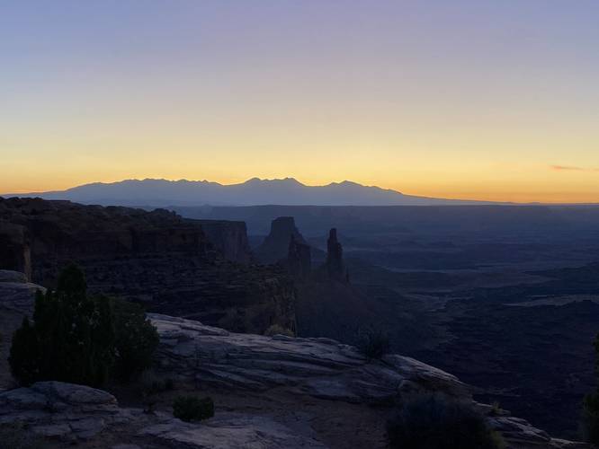
This hike begins at the main parking lot and trailhead for the Mesa Arch Trail located at the parking coordinates provided. This track heads in along a counter-clockwise loop and follows the southern-most part of the trail first. Along the way, the trail slowly ascends the landscape before dropping down to where the Mesa Arch is located. The trail is a wide dirt path that ascends short bedrock steps along the way. Due to the lack of trees, hikers will get views of Canyonlands' distant rock formations around them pretty much the entire way.
Mesa Arch - Mile 0.3
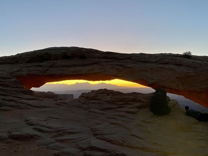
At mile 0.3, hikers will reach the Mesa Arch where it sits on the edge of Canyonlands' cliff. The view through the Mesa Arch includes the La Sal Mountains in the distance. The arch is not very tall, maybe 8-feet tall at its highest point, but it's elongated so it provides hikers with a wide landscape view.
After visiting the Mesa Arch, hikers can stop at an off-trail view of the La Sal Mountains located just uphill from the arch. After that, the trail leads back to parking by following a similar elevation grade that leads uphill and then down to the parking lot -- along the way, hikers will follow short series of stairs built into the trail.
Parking
Hikers will find a large parking lot at the coordinates provided, located on the eastern side of Grand View Point Road in Canyonlands National Park. The lot is large enough to fit a couple dozen vehicles. There's also roadside overflow parking available.
Popularity
This is one of the most popular hikes at Canyonlands National Park. Hikers especially show-up early to catch the sunrise each morning -- as the sun makes its way over the La Sal Mountains and through the Mesa Arch, it's become a popular spot for photographers.
Pets
Dogs are not allowed on any trails at Canyonlands National Park. Please do not bring your dog here.
Warning
Sun exposure: This trail has very little shade and no water sources. Pack-in all water and wear sun screen and a hat to protect against sun exposure. It's smart to hike either in the early morning or late afternoon to avoid the intense desert sun.
No water: This trail has no water sources so you must pack-in all water. A general rule of thumb in the desert is 1 gallon of water per person per day.
Rattlesnakes: This is rattlesnake territory, so be on the lookout and give any rattlers you find plenty of space.
Fees
Vehicle entry fees to Canyonlands National Park is $30 as of September 2023.
Hike Description
This hike begins at the main parking lot and trailhead for the Mesa Arch Trail located at the parking coordinates provided. This track heads in along a counter-clockwise loop and follows the southern-most part of the trail first. Along the way, the trail slowly ascends the landscape before dropping down to where the Mesa Arch is located. The trail is a wide dirt path that ascends short bedrock steps along the way. Due to the lack of trees, hikers will get views of Canyonlands' distant rock formations around them pretty much the entire way.
Mesa Arch - Mile 0.3
At mile 0.3, hikers will reach the Mesa Arch where it sits on the edge of Canyonlands' cliff. The view through the Mesa Arch includes the La Sal Mountains in the distance. The arch is not very tall, maybe 8-feet tall at its highest point, but it's elongated so it provides hikers with a wide landscape view.
After visiting the Mesa Arch, hikers can stop at an off-trail view of the La Sal Mountains located just uphill from the arch. After that, the trail leads back to parking by following a similar elevation grade that leads uphill and then down to the parking lot -- along the way, hikers will follow short series of stairs built into the trail.
Parking
Hikers will find a large parking lot at the coordinates provided, located on the eastern side of Grand View Point Road in Canyonlands National Park. The lot is large enough to fit a couple dozen vehicles. There's also roadside overflow parking available.
Popularity
This is one of the most popular hikes at Canyonlands National Park. Hikers especially show-up early to catch the sunrise each morning -- as the sun makes its way over the La Sal Mountains and through the Mesa Arch, it's become a popular spot for photographers.
Pets
Dogs are not allowed on any trails at Canyonlands National Park. Please do not bring your dog here.
Warning
Sun exposure: This trail has very little shade and no water sources. Pack-in all water and wear sun screen and a hat to protect against sun exposure. It's smart to hike either in the early morning or late afternoon to avoid the intense desert sun.
No water: This trail has no water sources so you must pack-in all water. A general rule of thumb in the desert is 1 gallon of water per person per day.
Rattlesnakes: This is rattlesnake territory, so be on the lookout and give any rattlers you find plenty of space.
Fees
Vehicle entry fees to Canyonlands National Park is $30 as of September 2023.