The Meadow Hot Spring near Kanosh, Utah is an easy 0.4-mile out-and-back walk that leads to a popular natural hot spring located in the middle of an open meadow.
Walk Description
Note that hikers can also drive to this hot spring if they wish, following the same path, but the road is super rutted and is only recommended for large-wheeled 4-wheel drive vehicles. The walk starts at the large parking lot provided and follows the rutted road out to the eastern-most hot spring.
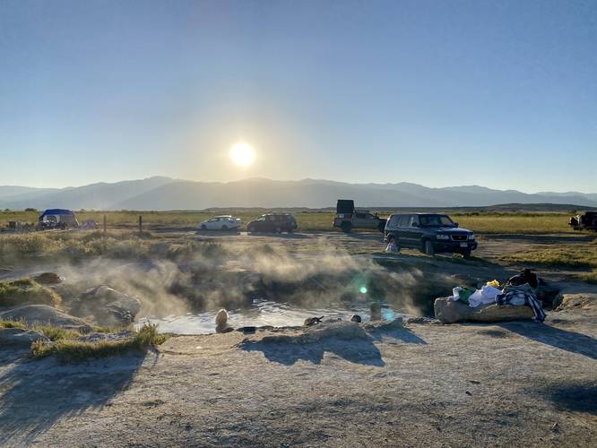
Meadow Hot Spring - Mile 0.2
Around mile 0.2, almost straight south from the parking lot, is the first hot spring. Upon our hike here, we showed up around 8AM to find at least 9 people already swimming or wading in the hot spring. One person was using a hammock to keep themselves afloat while two others were diving further down to see what the hot spring had to offer. After stopping by for just a shot minute, we left to continue our road trip; however, hikers can take an entire loop around the hot springs to find at least two more holes in the ground where you can explore more meadow hot springs.
Private Property (I think)
Note that this hot spring appears to sit on private property that's open to the public. There's a metal donation tube located near the trailhead / road entrance, so please be respectful of the land owners and fork over a small amount of cash to help protect and keep the place clean.
Parking
Hikers will find a large parking lot at the coordinates provided.
Camping
It appears as though camping is allowed along the roads to the hot spring. Again, I think this is private land, but unsure - and the signage encourages campers. Again, please leave a small donation to help protect the area.
Pets
Dogs are allowed if leashed and must be cleaned up after.
Walk Description
Note that hikers can also drive to this hot spring if they wish, following the same path, but the road is super rutted and is only recommended for large-wheeled 4-wheel drive vehicles. The walk starts at the large parking lot provided and follows the rutted road out to the eastern-most hot spring.
Meadow Hot Spring - Mile 0.2
Around mile 0.2, almost straight south from the parking lot, is the first hot spring. Upon our hike here, we showed up around 8AM to find at least 9 people already swimming or wading in the hot spring. One person was using a hammock to keep themselves afloat while two others were diving further down to see what the hot spring had to offer. After stopping by for just a shot minute, we left to continue our road trip; however, hikers can take an entire loop around the hot springs to find at least two more holes in the ground where you can explore more meadow hot springs.
Private Property (I think)
Note that this hot spring appears to sit on private property that's open to the public. There's a metal donation tube located near the trailhead / road entrance, so please be respectful of the land owners and fork over a small amount of cash to help protect and keep the place clean.
Parking
Hikers will find a large parking lot at the coordinates provided.
Camping
It appears as though camping is allowed along the roads to the hot spring. Again, I think this is private land, but unsure - and the signage encourages campers. Again, please leave a small donation to help protect the area.
Pets
Dogs are allowed if leashed and must be cleaned up after.