Matson Spring Falls at Tioga State Forest near Wellsboro, Pennsylvania is a difficult 0.2-mile out-and-back canyon creek scramble that leads up to the two-tiered 20-foot waterfall, Matson Spring Falls.
Hike Description
This is not necessarily a hike but rather a rocky bushwhack creek scramble that leads up the side of the canyon. The "trailhead" is technically just the rocky creek itself - located near the parking turnout at the coordinates provided - and often covered in tree debris that flow down the mountainside during periods of heavy rain or flash flooding. The hiker will begin here - heading up the loose rocky creek bed for almost the entire way.
Along the way up, during most seasons, the creek will be dry for the first 1/3 of the scramble uphill, as such, it's smart to move out of the creek bed once it becomes more wet to prevent slipping, sliding, or breaking an ankle; however, you will have to move in and out of the creek bed's loose rocky terrain in order to make your way to the base of Matson Spring Falls regardless. A lot of the hillside walking is steep and slippery as the ground below is generally made up of loose soil covered by leaves.
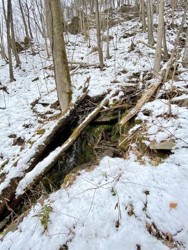
4-foot Waterfall - Mile 0.09
Around mile 0.09, hikers may notice another small 4-foot cascade spilling over bedrock as you make your way up the creek. That waterfall is located on the southern side of the split creek flow.
Eventually the hiker will be ~100-feet away from the base of the waterfall and has a choice - either cross the creek to enter the wet rocks to ascend or stay on the side where the canyon's steep hillside can be used to keep your balance - either way, watch your footing and take each step carefully to make your way to the base of the waterfall.
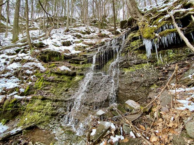
Matson Spring Falls - Mile 0.1
After climbing 200-feet in just 0.1-miles, hikers will reach the base of Matson Spring Falls, which has a 15-foot vertical drop. Just above that 15-foot waterfall is another ~5-foot vertical drop, the upper tier of Matson Spring Falls, which makes up the remaining height of this 20-foot cascade. Simply put, the lower 15-foot section of Matson Spring Falls is the only visible part of the waterfall with the upper tier visible only from further downstream. The footing around Matson Spring Falls is scarce as there are just a few places that you can stand without feeling like you'll accidentally trip backwards and fall down the steep rocky creek bed - for this reason, it's important to watch where you're stepping or standing. Note that the terrain surrounding the upper 5-foot waterfall tier appears to be another steep sloping canyon, so reaching that waterfall for a photo is generally inaccessible unless you're ice climbing.
Hiking Out
As stated previously, the loose rocky terrain makes this hike pretty challenging - on the way up, you generally scramble with your hands to provide additional balance; however, on the way down you can, instead, use your butt or lower your center of gravity to make heading down these rocks less sketchy.
Parking
Hikers will find a parking turnout at the coordinates provided along Owassie Road - the lot is large enough to fit about 5 vehicles.
Pets
Dogs are allowed if leashed and cleaned-up after; however, due to the loose rocky terrain, it's probably best to keep your dog off of this terrain.
Warnings
Steep terrain, loose rocks: This path leads up a steep rocky creek bed, which is often wet and slippery (or icy during the Winter). Watch your steps.
Creek hike: Due to flash flooding, this creek could have high water or a flash flood could potentially happen upstream, causing a large flow of water in the creek.
Timber Rattlesnakes: This area is home to the Timber Rattlesnake which generally is out roaming between the end of April and early October each year. They tend to drink and hunt near creeks, so be on the lookout for hidden rattlers during those months and give them space if you find any.
Hike Description
This is not necessarily a hike but rather a rocky bushwhack creek scramble that leads up the side of the canyon. The "trailhead" is technically just the rocky creek itself - located near the parking turnout at the coordinates provided - and often covered in tree debris that flow down the mountainside during periods of heavy rain or flash flooding. The hiker will begin here - heading up the loose rocky creek bed for almost the entire way.
Along the way up, during most seasons, the creek will be dry for the first 1/3 of the scramble uphill, as such, it's smart to move out of the creek bed once it becomes more wet to prevent slipping, sliding, or breaking an ankle; however, you will have to move in and out of the creek bed's loose rocky terrain in order to make your way to the base of Matson Spring Falls regardless. A lot of the hillside walking is steep and slippery as the ground below is generally made up of loose soil covered by leaves.
4-foot Waterfall - Mile 0.09
Around mile 0.09, hikers may notice another small 4-foot cascade spilling over bedrock as you make your way up the creek. That waterfall is located on the southern side of the split creek flow.
Eventually the hiker will be ~100-feet away from the base of the waterfall and has a choice - either cross the creek to enter the wet rocks to ascend or stay on the side where the canyon's steep hillside can be used to keep your balance - either way, watch your footing and take each step carefully to make your way to the base of the waterfall.
Matson Spring Falls - Mile 0.1
After climbing 200-feet in just 0.1-miles, hikers will reach the base of Matson Spring Falls, which has a 15-foot vertical drop. Just above that 15-foot waterfall is another ~5-foot vertical drop, the upper tier of Matson Spring Falls, which makes up the remaining height of this 20-foot cascade. Simply put, the lower 15-foot section of Matson Spring Falls is the only visible part of the waterfall with the upper tier visible only from further downstream. The footing around Matson Spring Falls is scarce as there are just a few places that you can stand without feeling like you'll accidentally trip backwards and fall down the steep rocky creek bed - for this reason, it's important to watch where you're stepping or standing. Note that the terrain surrounding the upper 5-foot waterfall tier appears to be another steep sloping canyon, so reaching that waterfall for a photo is generally inaccessible unless you're ice climbing.
Hiking Out
As stated previously, the loose rocky terrain makes this hike pretty challenging - on the way up, you generally scramble with your hands to provide additional balance; however, on the way down you can, instead, use your butt or lower your center of gravity to make heading down these rocks less sketchy.
Parking
Hikers will find a parking turnout at the coordinates provided along Owassie Road - the lot is large enough to fit about 5 vehicles.
Pets
Dogs are allowed if leashed and cleaned-up after; however, due to the loose rocky terrain, it's probably best to keep your dog off of this terrain.
Warnings
Steep terrain, loose rocks: This path leads up a steep rocky creek bed, which is often wet and slippery (or icy during the Winter). Watch your steps.
Creek hike: Due to flash flooding, this creek could have high water or a flash flood could potentially happen upstream, causing a large flow of water in the creek.
Timber Rattlesnakes: This area is home to the Timber Rattlesnake which generally is out roaming between the end of April and early October each year. They tend to drink and hunt near creeks, so be on the lookout for hidden rattlers during those months and give them space if you find any.