Loading...

❄️ WINTER SALE! 50% OFF on Supporter Accounts — now through January 31st. Unlock a full year of exclusive website & app perks. Learn More.

Mason Neck Loop Hike

Mason Neck State Park, just south of Fort Belvoir in the Lorton VA area, is a treasure of 10 hiking trails passing through diverse scenery and flora. Mostly flat, this park is the perfect location for a weekend picnic and hike, and suitable for all skill levels. Mason Neck State Park covers 1,825 acres, and is one of several wildlife and recreation areas in Mason Neck, with a total area dedicated to wildlife management and recreation of over 6.400 acres.


With a sandy beach and wetland marsh along the Bay View Trail, to meadow views and bird blinds, the park has something for everyone. With 200 different species of birds that call the park home, this area is a bird watchers paradise. 
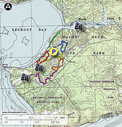
The 7.5 mile hike listed here utilizes all but a couple of trail sections and passes all the highlights in the park.

  • Mile 0.0 - From the parking area at the picnic ground start at the kiosk and red blazed Bay View Trail. From the kiosk pick up one of the trail brochures that highlight some of the features on the trail. Follow the path on the right along Belmont Bay where shortly the trail will join a boardwalk. The waterline is being protected from erosion by long Gabion Basket walls. Arrive at the first fresh water marsh on the left, then the boardwalk will pass a section of sandy beach. Cross the long boardwalk to the other side of the marsh and climb the stairs to a 4-way intersection.
  • Mile 0.5 - Turn right to complete the smaller loop side of the Bay View Trail. At the far end of the small loop is a bird blind of the western section of the marsh. Continue and complete the loop back to the 4-way intersection. Turn right continuing on the red Bay View Trail and arrive at the intersection with the yellow blazed Wilson Spring Trail. Turn right, the yellow trail will pass through several gullies before reaching the intersection of the Dogue Trail and Wilson Spring parking area.
  • Mile 1.19 - Turn right on the orange blazed Dogue Trail and shortly pass the loop intersection. Continue straight on the orange Dogue Trail and follow it around to the left and intersection with the purple blazed Meadow View Trail.
  • Mile 1.64 - Turn right on the purple Meadow View Trail. The trail is narrower than the more path like Dogue Trails. The Meadow View Trail offers the most elevation gain of the hike. Cross multiple wooden board walks, then arrive at the trails end and elevated bird blind over a large field. Return back to the t-juntion with the Dogue Trail and turn right. Follow the path back to the loop start, turn right and arrive at the Wilson Spring Trail parking area and main park road. Cross the road on the yellow blazed Wilson Spring Trail then soon arrive at the intersection of the blue blazed Kane's Creek trail.
  • Mile 4.32 - Turn right on the blue Kane's Creek Trail and in fifty yards the white blazed Eagle Spur Trail will enter on the right. Turn right on the white Eagle Spur trail and follow it through several small gullies. The trail is named for the Eagle Scouts that built it, and not the eagles that can be found in the park. Just before arriving a the elevated bird blind over Kane's Creek the trail will enter a stand of Mountain Laurel. Return on the Eagle Spur Trail bask to the intersection with the Kane's Creek Trail.
  • Mile 6.71 - Turn right on the wider blue blazed Kane's Creek trail, and pass the loop section of the trail in 0.3 miles. Continue straight on the blue Kane's Creek Trail for the remaining 0.49 miles to the main picnic area.
  • Mile 7.1 - Arrive back at the picnic and parking area.
Explore 13 trails near Lorton, VA

Know Before You Go

  • The Mason Neck Loop Hike in Mason Neck State Park (Lorton, VA) is a 7.1-mile, mostly flat trail suitable for all skill levels, offering diverse scenery and a chance to experience the park's flora and fauna.
  • The hike features various highlights including a sandy beach, wetland marsh (Bay View Trail), meadow views, and bird blinds, making it a prime location for bird watching with over 200 bird species.
  • The route utilizes multiple trails (Bay View, Wilson Spring, Dogue, Meadow View, Kane's Creek, Eagle Spur), ensuring hikers experience key features and highlights of the park.
Interactive topographic map for Mason Neck Loop Hike located in Lorton, VA. Click the "View Map" button to load GPS coordinates and trail markers.
Get directions
Distance
7.1 mi
Difficulty
Moderate
Type
Out-and-Back
Est. Time
3.6 hrs
Elev. Gain
224'
Rating
3.5
Added
April 03, 2025
Updated
April 06, 2025

Weather Forecast

Loading...
Total Change
33'
Ascent
224'
Descent
227'
Loading...

Download the GPX Data for Offline Use

Supporters get exclusive access to download trail routes to the MyHikes app for offline use. Stay prepared on your adventure, even without an internet connection! Become a Supporter today to unlock this feature and hike with confidence.

Download Mason Neck Loop Hike GPX Data to the MyHikes Mobile App

Features

Vista / Lookout Point
Dogs

Points of interest

  1. Parking

    38.642352, -77.198711
  2. Main Trailhead

    38.642352, -77.198711

Safety information

For your own safety: plan ahead, let someone know where you'll be, and hike at your own risk.

Hazards

Snakes (Rattlesnakes, Copperheads, others)
Poison Ivy or Poison Oak

Availability

All seasons

Surface type

Dirt

Trip Reports (Reviews)

Rated 3.5 out of 5 based on 2 ratings.

Ready to help fellow hikers? Add a trip report to share your experience and provide valuable insights for other hikers!

By: aldikuma
7.1 miles / 11.4 km
October 18, 2016
I've lived in NoVA for many years, but this was only the second time I'd been here. The trails are easy, well-maintained, and there's a lot of amenities here to enjoy before and after your hike (picnic tables, playground, open grassy fields, Visitor's Center). I can't speak for the weekends, but on a weekday, the solitude was better than I anticipated for a place so close to DC. It is $4 to enter for residents.
Legacy Review
By: Steve
7.1 miles / 11.4 km
May 26, 2016
A great hike made up of four smaller trails. Any of the four would be good for anyone wanting a shorter hike, with the red Bay View Trail probably the most intriguing to kids. There's a beach I didn't take the time to see but would like to later. There are other trails, one paved. It's nice to see several trails in the park deemed "handicapped accessible" according to the trail guide brochure, including the orange Dogue Trail on this hike, which is relatively smooth. The trails are in good condition. Just saw three others on the hike. As a non-resident of Virginia, I paid $6 to enter the park and received a collection of literature including a trail map, not as detailed as the one on this web site. Friendly staff, restrooms, Coke machines, drinking water, a playground, picnic areas, too. There's a visitor center I did not check out.
Legacy Review
No community routes found. To add your own hike as a Community Route for this Trail guide, leave a Trip Report with an attached GPX file.

Popular categories

Scenic mountain view representing vista trails
Vista trails
Scenic gorge of cascades representing waterfall trails
Waterfall hikes
Rugged mountain terrain representing summit trails
Summit trails
Scenic mountain view representing dog-friendly trails
Dog-friendly
Scenic campsite with a view representing camping trails
Camping trails
Appalachian Trail logo representing A.T. hikes
A.T. hikes

You May Also Like

25 Best Day Hikes in North Carolina - Discover the top 25 best day hikes in North Carolina, from breathtaking waterfalls to mountain peaks. Explore hidden gems, scenic views, and trails suitable for all skill levels, perfect for your next outdoor adventure.
Explore

25 Best Day Hikes in North Carolina

Discover the top 25 best day hikes in North Carolina, from breathtaking waterfalls to mountain peaks. Explore hidden gems, scenic views, and trails suitable for all skill levels, perfect for your next outdoor adventure.

Read
🍪 We use cookies to learn about site usage and to serve map tiles. You may block cookies manually in the browser. By continuing you agree. Learn more